Bremridge Wood

Last updated

Coordinates: 51°02′38″N3°52′20″W / 51.0439°N 3.8722°W / 51.0439; -3.8722

Geographic coordinate system Coordinate system

A geographic coordinate system is a coordinate system that enables every location on Earth to be specified by a set of numbers, letters or symbols. The coordinates are often chosen such that one of the numbers represents a vertical position and two or three of the numbers represent a horizontal position; alternatively, a geographic position may be expressed in a combined three-dimensional Cartesian vector. A common choice of coordinates is latitude, longitude and elevation. To specify a location on a plane requires a map projection.

Bremridge Wood Bremridge Wood - geograph.org.uk - 576455.jpg
Bremridge Wood

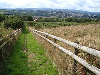
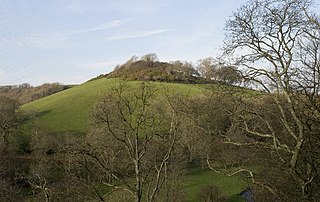
Bremridge Wood formerly part of the Domesday Book estate of Bremridge near South Molton, Devon, England, is the site of an Iron Age enclosure or hill fort. The earthwork is situated in woodland on a Hillside forming a promontory above the River Bray to the West of the Town at approx 175 Metres above Sea Level. [1] [2]

Domesday Book 11th-century survey of landholding in England as well as the surviving manuscripts of the survey

Domesday Book is a manuscript record of the "Great Survey" of much of England and parts of Wales completed in 1086 by order of King William the Conqueror. The Anglo-Saxon Chronicle states:

Then, at the midwinter [1085], was the king in Gloucester with his council .... After this had the king a large meeting, and very deep consultation with his council, about this land; how it was occupied, and by what sort of men. Then sent he his men over all England into each shire; commissioning them to find out "How many hundreds of hides were in the shire, what land the king himself had, and what stock upon the land; or, what dues he ought to have by the year from the shire."

Bremridge

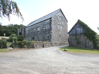
Bremridge is a historic estate within the former hundred of South Molton in Devon, England. It is now within the parish of Filleigh but was formerly in that of South Molton. It is situated 8 miles north-west of South Molton. Since the construction of the nearby A361 North Devon Link Road direct access has been cut off from Bremridge to Filleigh and South Molton. The surviving wing of the mansion house built in 1654 is a Grade II* listed building. Bremridge Wood is the site of an Iron Age enclosure or hill fort, the earthwork of which is situated on a hillside forming a promontory above the River Bray. In Bremridge Wood survives a disused tunnel of the former Great Western Railway line between South Molton and Barnstaple, much of the course of which has been used for the A361. The tunnel is 319 yards long and was identified as "Bremridge Tunnel" in the 1889 Ordnance Survey map but as "Castle Hill Tunnel" in subsequent editions.

South Molton town in Devon, England

South Molton is a small town in Devon, England. It is part of the North Devon local government district. The town is on the River Mole. According to the 2001 census the civil parish of South Molton had a population of 4,093, increasing to 5,108 at the 2011 Census. The town also has an electoral ward with the same name. The population of this ward at the same census was 4,875 We have therefore the unusual situation where the town is larger than the ward. The town was one of the boroughs reformed by the Municipal Reform Act 1835. It retained this status as a municipal borough until 1967, when it became a rural borough in the South Molton Rural District.

Related Research Articles

Hawkesdown Hill hillfort in Devon

Hawkesdown Hill is an Iron Age Hill fort close to Axmouth in Devon situated on a prominent hillside above the Axe Estuary. It is approximately 130 metres (430 ft) above sea level.

Beacon Castle is an Iron Age hill fort close to Parracombe in Devon, England. It is situated on a hilltop some 290 metres (950 ft) above sea level, overlooking the Heddon Valley.

Voley Castle is an Iron Age hill fort, situated close to Parracombe in Devon, England. The fort is situated on a promontory on the Eastern side of Heale Down, approximately 230 Metres above Sea Level.

Castle Dyke Iron Age hill fort situated between Chudleigh and Dawlish in Devon, England

Castle Dyke is an Iron Age hill fort situated between Chudleigh and Dawlish in Devon, England. The fort is situated on a Hilltop at approx 140 metres above sea level.

Berry's Wood is an Iron Age hill fort situated close to Newton Abbot in Devon, England. The fort is situated at about 75 metres above sea level on a commanding promontory above the River Lemon with views down the Teign Estuary. It lies on the hilltop above Bradley Manor.

Milber Down hillfort in Devon

Milber Down is an Iron Age hill fort on the hill above the suburb of Milber, Newton Abbot in Devon, England. The fort is situated on the north-western slope of Milber Down at about 110 metres above sea level, and is bisected by the minor ridge road that leads to Barton, Torquay. One Iron Age artefact discovered there was a figurine of a stag.

Holne Chase Castle is an Iron Age hill fort situated close to Buckland-in-the-Moor in Devon, England. The fort is situated on a promontory on the Northern slopes of Holne Chase in Chase Wood at approx 150 Metres above Sea Level overlooking the River Dart.

Brent Hill hillfort in Devon

Brent Hill is the site of an Iron Age hill fort situated close to South Brent in Devon, England. The fort occupies the top of Brent Hill at approx 311 Metres above Sea Level.

Yellowberries Copse is an Iron Age enclosure, or possibly hill fort situated South of South Brent in Devon, England. The fort is situated on the North West slope of Cutwell Hill at approx 155 Metres above Sea Level.

Halwell Camp

Halwell Camp is an Iron Age hill fort situated close to the village of Halwell in Devon, England. The fort is situated on a pass between two hilltops to the east of the village at approx 185 metres above sea level.

Capton village in United Kingdom

Capton is a village near Dartmouth in Devon, England.

Holbury is an Iron Age hill fort situated close to Holbeton in Devon, England. The fort is situated on a hilltop east of the Village approximately 95 metres above sea level overlooking the Erme Estuary.

Yarrowbury is an Iron Age hill fort situated close to Bigbury in Devon, England. The fort is situated on Hilltop to the north east of the village at approximately 80 metres above sea level, overlooking the Avon Estuary.

Smythapark is the site of an Iron Age hill fort, situated close to the village of Bratton Fleming in Devon, England. The site is on a hillside forming a promontory above a tributary of the River Yeo to the west of the village, at approximately 200 metres (660 ft) above sea level. The surrounding area is rich in small enclosures.

Kentisbury Down is the location of an Iron Age enclosure or hill fort situated close to Blackmore Gate on the edge of Exmoor in Devon, England. The enclosure—a simple 'round'—is situated on the southeast slope of the down above the ancient crossroads at approx 320 metres above sea level.

Roborough Castle

Roborough Castle is an Iron Age enclosure or hill fort situated close to Lynton in Devon, England. The fort is situated on the North East edge of a Hillside forming a promontory above a tributary to the East Lyn River known as Hoaroak Water at approx 320 Metres above Sea Level.

Cunnilear Camp is an Iron Age hill fort close to the village of Loxhore in Devon, England. It is on a hillside forming a promontory above the River Yeo to the south of the village, at approximately 110 metres (360 ft) above sea level.

Myrtlebury is an Iron Age enclosure or 'spur' hill fort situated close to Lynmouth in Devon, England. The fort is effectively the north east of a hillside forming a spur or promontory above the steep valley of the East Lyn River to the east of the village, at approximately 150 metres above sea level.

Knowle Hill Castle

Knowle Hill Castle is an Iron Age hill fort situated close to Braunton in Devon, England. The fort is situated on a hillside forming a promontory above the River Caen at approx 90 metres above sea level to the north of the town, close to the village of Knowle.

Lee Wood

Lee Wood is the location of an Iron Age enclosure or hill fort situated near to Braunton and Barnstaple in Devon, England. The enclosure is situated on a sloping Hillside forming a promontory above the Knowle Water at approx 120 Metres above Sea Level to the north east of Braunton and north west of Barnstaple.

References

  1. Sellman, R.R. (1985). "The Iron Age in Devon (ch.2)". Aspects of Devon History. Exeter: Devon Books. pp. 11 (Map of Iron Age hill forts in Devon shows location of Bremridge Wood). ISBN   0-86114-756-1.
  2. Whybrow, Charles (1970). "The Early Iron Age (ch.4)". Antiquary's Exmoor. Dulverton: Exmoor Press. pp. 23 (Mention of Bremridge Wood as example of an 'overlapping entrance' spur fortification). ISBN   978-0-9500133-4-3.