Related Research Articles
Oseberg is an offshore oil field with a gas cap in the North Sea located 140 km (87 mi) northwest of the city of Bergen on the southwestern coast of Norway. The field, which is 25 km long by 7 km wide, was discovered in 1979 and its development is known to be one of the significant milestones in emergence of Norway's independent oil and gas industry. The Oseberg field was named after Oseberg ship, one of Norway's most significant archeological discoveries. The ancient Viking ship from the early 9th century was discovered in a 1904 historical excavation of a burial mound at the Oseberg Farm, south of Oslo.

The Moine Thrust Belt or Moine Thrust Zone is a linear tectonic feature in the Scottish Highlands which runs from Loch Eriboll on the north coast 190 kilometres (120 mi) south-west to the Sleat peninsula on the Isle of Skye. The thrust belt consists of a series of thrust faults that branch off the Moine Thrust itself. Topographically, the belt marks a change from rugged, terraced mountains with steep sides sculptured from weathered igneous, sedimentary and metamorphic rocks in the west to an extensive landscape of rolling hills over a metamorphic rock base to the east. Mountains within the belt display complexly folded and faulted layers and the width of the main part of the zone varies up to 10 kilometres (6.2 mi), although it is significantly wider on Skye.

Yaverlandia is a genus of maniraptoran dinosaur. Known from a partial fossil skull found in Lower Cretaceous strata of the Wessex Formation on the Isle of Wight. it was described as the earliest known member of the pachycephalosaurid family, but research by Darren Naish shows it to have actually been a theropod, seemingly a maniraptoran. The type species is Y. bitholus.
Ornithopsis is a genus of sauropod dinosaur, from the Early Cretaceous of England. The type species, which is the only species seen as valid today, is O. hulkei, which is only known from fragmentary remains, and has been regarded by many authors as dubious.
Early Earth is loosely defined as encompassing Earth in its first one billion years, or gigayear (Ga, 109 y), from its initial formation in the young Solar System at about 4.55 Ga to some time in the Archean eon in approximately 3.5 Ga. On the geologic time scale, this comprises all of the Hadean eon, starting with the formation of the Earth about 4.6 billion years ago, and the Eoarchean, starting 4 billion years ago, and part of the Paleoarchean era, starting 3.6 billion years ago, of the Archean eon.

Dendrerpeton is a genus of an extinct group of temnospondyl amphibians. Its fossils have been found primarily in the Joggins Formation of Eastern Canada and in Ireland. It lived during the Carboniferous and is said to be around 309–316 million years of age, corresponding to more specifically the Westphalian (stage) age. Of terrestrial temnospondyl amphibians evolution, it represents the first stage. Although multiple species have been proposed, the species unanimously recognized is D. acadianum. This species name comes from “Acadia” which is a historical name for the Nova Scotia region as a French colony. It refers to the location of the coal field at which the fossil was found.

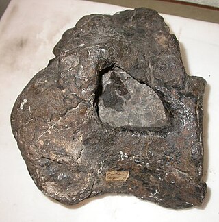
Knightoconus antarcticus is an extinct species of fossil monoplacophoran from the Cambrian Minaret Formation of Antarctica. It is thought to represent an ancestor to the cephalopods. It had a chambered conical shell, but lacked a siphuncle.

Peter Alfred Ziegler was a Swiss geologist, who made contributions to the understanding of the geological evolution of Europe and the North Atlantic borderlands, of intraplate tectonics and of plate tectonic controls on the evolution and hydrocarbon potential of sedimentary basins. Ziegler's career consists of 33 years as exploration geologist with the petroleum industry, 30 of which with Shell, and 20 years of university teaching and research.

Edmund Johnston Garwood was a British geologist and President of the Geological Society of London from 1930 to 1932.
The Moine Supergroup is a sequence of Neoproterozoic metamorphic rocks that form the dominant outcrop of the Scottish Highlands between the Moine Thrust Belt to the northwest and the Great Glen Fault to the southeast. The sequence is metasedimentary in nature and was metamorphosed and deformed in a series of tectonic events during the Late Proterozoic and Early Paleozoic. It takes its name from A' Mhòine, a peat bog in northern Sutherland.
The Armada gas field complex is a group of natural gas fields located in the Central North Sea 250 kilometres (160 mi) NE of Aberdeen, within the United Kingdom Continental Shelf. The field was operated by BG Group and is now operated by Shell. The complex consists of several fields developed via a central platform located in 88 metres (289 ft) of water. The Fleming and Hawkins fields were discovered in 1980 and the Drake and Seymour Fields in 1982. Development approval was granted in 1994 and production started in 1997. The gas is exported via the Central Area Transmission System through a link to the Everest gasfield. Oil is exported via the Forties oil field to Grangemouth. The fields had a maximum production rate of 450 million cubic feet per day and 24 thousand barrels per day.

The geology of East Sussex is defined by the Weald–Artois anticline, a 60 kilometres (37 mi) wide and 100 kilometres (62 mi) long fold within which caused the arching up of the chalk into a broad dome within the middle Miocene, which has subsequently been eroded to reveal a lower Cretaceous to Upper Jurassic stratigraphy. East Sussex is best known geologically for the identification of the first dinosaur by Gideon Mantell, near Cuckfield, to the famous hoax of the Piltdown man near Uckfield.
The Weald Basin is a major topographic feature of the area that is now southern England and northern France from the Triassic to the Late Cretaceous. Its uplift in the Late Cretaceous marked the formation of the Wealden Anticline. The rock strata contain hydrocarbon deposits which have yielded coal, oil and gas.

The Jeanne d'Arc Basin is an offshore sedimentary basin located about 340 kilometres to the basin centre, east-southeast of St. John's, Newfoundland and Labrador. This basin formed in response to the large scale plate tectonic forces that ripped apart the super-continent Pangea and also led to sea-floor spreading in the North Atlantic Ocean. This basin is one of a series of rift basins that are located on the broad, shallow promontory of continental crust known as the Grand Banks of Newfoundland off Canada's east coast. The basin was named after a purported 20 metres shoal labelled as "Ste. Jeanne d'Arc" on out-dated bathymetric charts and which was once thought to represent a local exposure of basement rocks similar to the Virgin Rocks.

The Great Estuarine Group is a sequence of Middle Jurassic sedimentary rocks deposited in the Inner Hebrides of Scotland. The sedimentary sequence was originally named the 'Great Estuarine Series' by geologist John Wesley Judd in 1878. Sedimentary outcrops occur on Skye, Raasay, Eigg and Muck. It comprises a series of shales, clays, silts, mudstones, and sandstones deposited in two drainage basins: the Inner Hebrides basin and the Sea of the Hebrides basin. The sediments are equivalent in age to the Inferior and Great Oolite Groups found in southern England.
Duncorn Hill is an English, landmark, rounded hill with a flat top close to the Fosse Way. It is located on a limestone plateau south of Bath in Somerset and summits at 585 feet (178 m) above sea level. The hill's name derives from Celtic din for fort and corn meaning horn shaped.

The Sherwood Sandstone Group is a Triassic lithostratigraphic group which is widespread in Britain, especially in the English Midlands. The name is derived from Sherwood Forest in Nottinghamshire which is underlain by rocks of this age. It has economic importance as the reservoir of the Morecambe Bay gas field, the second largest gas field in the UK.

The North Sea is part of the Atlantic Ocean in northern Europe. It is located between Norway and Denmark in the east, Scotland and England in the west, Germany, the Netherlands, Belgium and France in the south.

The North German Basin is a passive-active rift basin located in central and west Europe, lying within the southeasternmost portions of the North Sea and the southwestern Baltic Sea and across terrestrial portions of northern Germany, Netherlands, and Poland. The North German Basin is a sub-basin of the Southern Permian Basin, that accounts for a composite of intra-continental basins composed of Permian to Cenozoic sediments, which have accumulated to thicknesses around 10–12 kilometres (6–7.5 mi). The complex evolution of the basin takes place from the Permian to the Cenozoic, and is largely influenced by multiple stages of rifting, subsidence, and salt tectonic events. The North German Basin also accounts for a significant amount of Western Europe's natural gas resources, including one of the world's largest natural gas reservoir, the Groningen gas field.
The geology of Saudi Arabia includes Precambrian igneous and metamorphic basement rocks, exposed across much of the country. Thick sedimentary sequences from the Phanerozoic dominate much of the country's surface and host oil.
References
- ↑ Richards, P.C. "An introduction to the Brent Group: a literature review". In Morton, A.C.; Haszeldine, R.S.; Giles, M.R.; Brown, S. (eds.). Geology of the Brent Group. Special Publications. Vol. 61. Geological Society. pp. 15–26. doi:10.1144/GSL.SP.1992.061.01.03.
- ↑ British Geological Survey. "Brent Group". The BGS Lexicon of Named Rock Units.
- ↑ Struijk, A.P.; Green, R.T. (1991). Abbotts, I.L. (ed.). United Kingdom Oil and Gas Fields, 25 Years Commemorative Volume. Geological Society Memoir. Vol. 14. Geological Society. pp. 63–72. doi:10.1144/GSL.MEM.1991.014.01.0.