
Kennebunk is a town in York County, Maine, United States. The population was 11,536 at the 2020 census. Kennebunk is home to several beaches, the Rachel Carson National Wildlife Refuge, the 1799 Kennebunk Inn, many historic shipbuilders' homes, the Brick Store Museum and the Nature Conservancy Kennebunk Plains, with 1,500 acres (6 km2) of nature trails and blueberry fields. The municipality includes the constituent villages of Kennebunk Village (Town), the Lower Village, Kennebunk Landing, Bartlett Mills, West Kennebunk, Kennebunk Beach, Lords Point, Coopers Corner Crossing, Sea Roads Crossing, Webahennet Grove, and Vinegarhill, Cheshire Commons, Kennebunk Meadows, and various newer neighborhoods.

The Wilson Building is an historic 8-story building in the Main Street district of downtown Dallas, Texas. The building was completed in 1904 and patterned after the Palais Garnier in Paris, France. The historic structure fronts Main Street on the south, Ervay Street on the east, and Elm Street on the north. The Wilson building was the tallest structure in Dallas from 1904–1909 and was considered the premier commercial structure west of the Mississippi. The Wilson Building is situated across from the flagship Neiman Marcus Building and is adjacent to the Mercantile National Bank Building.

Yarmouth is a town in Cumberland County, Maine, United States, twelve miles north of the state's largest city, Portland. When originally settled in 1636, as North Yarmouth, it was part of Massachusetts, and remained as such for 213 years. In 1849, twenty-nine years after Maine's admittance to the Union as the twenty-third state, it was incorporated as the Town of Yarmouth.
The historical buildings and structures of Yarmouth, Maine, represent a variety of building styles and usages, largely based on its past as home to almost sixty mills over a period of roughly 250 years. These mills include that of grain, lumber, pulp and cotton. Additionally, almost three hundred vessels were launched by Yarmouth's shipyards in the century between 1790 and 1890, and the homes of master shipwrights and ship captains can still be found throughout the town.
The history of Yarmouth, Maine, is closely tied to its position on the banks of the Royal River and its proximity to Casco Bay, an inlet of the Gulf of Maine, itself a gulf of the Atlantic Ocean.

Sparhawk Mill is a former cotton mill on Bridge Street in Yarmouth, Maine, United States. Built in 1840 and made of brick, it is home today to The Garrison restaurant and several other businesses. It stands, just east of the town's Second Falls, on the site of several previous mill buildings, the earliest of which was a wooden mill dating to 1817.

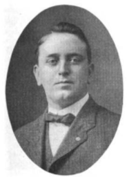
Frank Addison Knight was an arborist from Yarmouth, Maine, United States. One of his most prominent roles was as the tree warden for "Herbie", an American elm that stood in Yarmouth for over 200 years. It was a role he held for around the last fifty years of the tree's life. "Herbie" was the oldest and largest American elm in New England. The tree was cut down in 2010 after succumbing to Dutch elm disease. Knight's efforts to extend the tree's life brought him international attention. He estimated he saved the tree's life on fourteen occasions over five decades. "It's his time now, and soon it will be mine," a 101-year-old Knight said, attending the tree's removal on January 19, 2010.

William Hutchinson Rowe was an American author and historian who lived in Yarmouth, Maine. The town's elementary school, built the year he died, is now named for him. In 1937, he published Ancient North Yarmouth and Yarmouth, Maine 1636–1936: A History, covering three centuries of the town's past. As of the early 21st century, it was still in print.
Frank William Bucknam was an American pharmacist from Yarmouth, Maine. He was appointed Maine's Commissioner of Pharmacy in 1906, and was a delegate to the United States Pharmacopeial Convention in Washington, D.C., on several occasions.

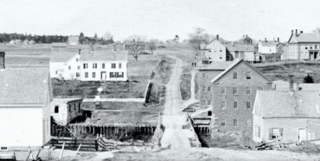
Forest Paper Company was a pulp and paper mill on the Royal River in Yarmouth, Maine, United States, which was in business between 1874 and 1923. It was the first of its kind in New England. In 1909, it was the largest such mill in the world, employing 275 people. It produced 80 tons of poplar pulp each day.

Main Street is a historic street in Yarmouth, Maine, United States. It is part of the 18-mile-long (29 km) State Route 115 (SR 115), the eastern terminus of which is in Yarmouth at the intersection of Marina Road and Lafayette Street (SR 88), at Yarmouth Harbor in the Lower Falls area. Its western end is a merging with Walnut Hill Road in North Yarmouth, at which point SR 115 continues west.
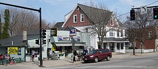
Andy's Handy Store, colloquially known as Handy Andy's, is a historic building in Yarmouth, Maine, United States. Located at 367 Main Street, at its junction with Elm Street in the town's Upper Village, part of the building dates to 1891. It has been the home to over thirty businesses. As of early 2022, Thoroughfare occupies the entire building.
Bridge Street is a historic street in Yarmouth, Maine, United States. It runs for about 0.36 miles (0.58 km) from Willow Street in the north to the town's Main Street, State Route 115, in the south. The street's elevation is around 75 feet (23 m) at each end, while its middle section, at its crossing of the Royal River, is around 13 feet (4.0 m), a drop of around 62 feet (19 m).
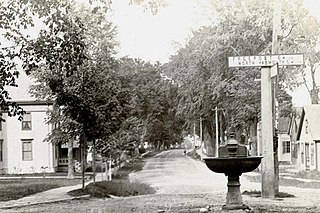
Elm Street is a prominent street in Yarmouth, Maine, United States. It runs for about 2.7 miles (4.3 km) from North Road in the north to Portland Street in the south. The street's addresses are split between "West Elm Street" and "East Elm Street", the transition occurring at Main Street in the Upper Village. Several of its buildings are homes dating to the late 18th and early 19th centuries.

Portland Street is a historic street in Yarmouth, Maine, United States. It runs for about 1.25 miles (2.01 km) from the town's Main Street, State Route 115, in the north to its merge with Middle Road in the south. It is so named because it leads to Portland, the state's largest city, after linking up with State Route 9 in Falmouth, Maine.
The First Falls are the first of four waterfalls in Yarmouth, Maine, United States. They are located on the Royal River, approximately a mile from its mouth with inner Casco Bay at Yarmouth Harbor and around 0.35 miles (0.56 km) downstream of the Second Falls. The river appealed to settlers because its 45-foot rise in close proximity to navigable water each provided potential waterpower sites. As such, each of the four falls was used to power 57 mills between 1674 and the mid-20th century.

35 East Main Street, also known as the Jeremiah Baker House, is a historic four-storey home at 35 East Main Street in the Lower Falls area of Yarmouth, Maine. Between 1780 and the turn of the 19th century, Lower Falls saw an increase in its population after early settlers gradually moved inland from the area around the Meetinghouse under the Ledge on Gilman Road. Built in 1848, possibly for William Stockbridge, before Yarmouth's secession from North Yarmouth, the home overlooks Yarmouth Marina, which was a bustling working harbor from the early to late 19th century, and the area of the harbor historically known as Grantville. It stands adjacent to the Johnathan True House.

The Fourth Falls, also known as Upper Falls or Gooch's Falls, are the fourth of four waterfalls in Yarmouth, Maine, United States. They are located on the Royal River, approximately 0.4 miles (0.64 km) upstream of the Third Falls. The river appealed to settlers because its 45-foot rise in close proximity to navigable water each provided potential waterpower sites. As such, the four falls were used to power 57 mills between 1674 and the mid-20th century.

68 East Main Street is a historic home in Yarmouth, Maine, United States. It was built in 1785, when the town was part of North Yarmouth, around seventy years after the "third, and earliest permanent, settlement" of the town.
Ammi Storer was an American merchant. He was prominent in today's Yarmouth, Maine, where a street is now named for him. He also worked in Boston, Massachusetts.


