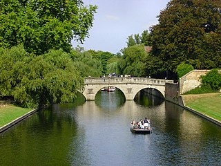
The River Cam is the main river flowing through Cambridge in eastern England. After leaving Cambridge, it flows north and east before joining the River Great Ouse to the south of Ely, at Pope's Corner. The total distance from Cambridge to the sea is about 40 mi (64 km) and is navigable for punts, small boats, and rowing craft. The Great Ouse also connects to England's canal system via the Middle Level Navigations and the River Nene. In total, the Cam runs for around 69 kilometres (43 mi) from its furthest source to its confluence with the Great Ouse.

The Leper Chapel, also known as the Leper Chapel of St Mary Magdalene, is a chapel on the east side of Cambridge, England, off Newmarket Road close to the railway crossing at Barnwell Junction. It dates from about 1125.

The Diocese of Ely is a Church of England diocese in the Province of Canterbury. It is headed by the Bishop of Ely, who sits at Ely Cathedral in Ely. There is one suffragan (subordinate) bishop, the Bishop of Huntingdon. The diocese now covers the modern ceremonial county of Cambridgeshire and western Norfolk. The diocese was created in 1109 out of part of the Diocese of Lincoln.
The Holy Sepulchre is a Norman round church in Sheep Street, Northampton, England. It is a Grade I listed building. Dating from circa 1100, it was possibly built by Simon de Senlis, Earl of Northampton.

The Church of the Holy Sepulchre, generally known as The Round Church, is an Anglican church in the city of Cambridge, England. It is located on the corner of Round Church Street and Bridge Street. Since 1950 the church has been designated a Grade I listed building, and is currently managed by Christian Heritage. It is one of the four medieval round churches still in use in England.

Candlewick is a small ward, one of the 25 ancient wards in the City of London, England.
The A607 is an A road in England that starts in Belgrave, Leicester and heads northeastwards through Leicestershire and the town of Grantham, Lincolnshire, terminating at Bracebridge Heath, a village on the outskirts of Lincoln. It is a primary route from Thurmaston to the A1 junction at Grantham.
Trumpington Street is a major historic street in central Cambridge, England. At the north end it continues as King's Parade where King's College is located. To the south it continues as Trumpington Road, an arterial route out of Cambridge, at the junction with Lensfield Road.

Downing Street is a street in central Cambridge, England. It runs between Pembroke Street and Tennis Court Road at the western end and a T-junction with St Andrew's Street at the eastern end. Corn Exchange Street and St Tibbs Row lead off to the north. Downing Place leads off to the south.

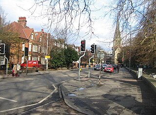
Jesus Lane is a street in central Cambridge, England. The street links with the junction of Bridge Street and Sidney Street to the west. To the east is a roundabout. To the south is King Street, running parallel with Jesus Lane and linking at the roundabout. The road continues east as Maid's Causeway and then Newmarket Road east out of Cambridge. To the north is Victoria Avenue between Jesus Green to the west and Midsummer Common to the east. Also to the north near the western end is Park Street, location of the ADC Theatre. To the south is Short Street, quickly leading into Emmanuel Road past Christ's Pieces.
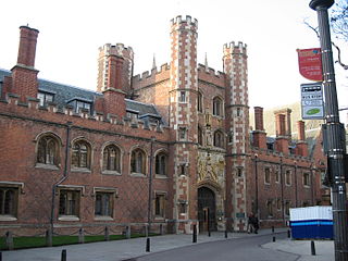
St John's Street is a historical street in central Cambridge, England. The street links with Bridge Street, Round Church Street, and Sidney Street to the north. It continues to the south as Trinity Street, then King's Parade and Trumpington Street. This thoroughfare is the main area for some of the most historic University of Cambridge colleges.
Magdalene Street is a street in the north of central Cambridge, England. It runs between Castle Street, by Castle Hill, at the junction with Northampton Street and Chesterton Lane, then Chesterton Road, to the northwest and Bridge Street at the junction with Thompson's Lane to the southeast.

Sidney Street is a major street in central Cambridge, England. It runs between Bridge Street at the junction with Jesus Lane to the northwest and St Andrew's Street at the junction with Hobson Street to the southeast.

Northampton Street is a street in the north of central Cambridge, England. It runs between Madingley Road and Queen's Road to the west and Castle Street, by Castle Hill, Chesterton Lane, and Magdalene Street to the east.

Bene't Street is a short historic street in central Cambridge, England, the name being derived from St Benedict. There is a junction with King's Parade to the north and Trumpington Street to the south at the western end of the street. Free School Lane leads off to the south. To the east, the street continues as Wheeler Street.
Hills Road is an arterial road in southeast Cambridge, England. It runs between Regent Street at the junction with Lensfield Road and Gonville Place to the northwest and a roundabout by the Cambridge Biomedical Campus, continuing as Babraham Road to the southeast.
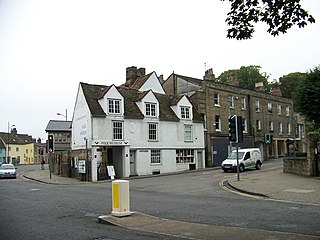
Castle Street is a street in the north of central Cambridge, England. To the southeast is a junction with Northampton Street, Magdalene Street, and Chesterton Lane. To the northwest is a junction with Mount Pleasant, Huntingdon Road, Histon Road, and Victoria Road.
Lensfield Road is a road in southeast central Cambridge, England. It runs between the junction of Trumpington Street and Trumpington Road to the west and the junction of Regent Street and Hills Road to the west. It continues as Gonville Place to the northeast past Parker's Piece, a large grassy area with footpaths.

The School of Pythagoras is the oldest building in St John's College, Cambridge, and the oldest secular building in Cambridge, England. It is a Grade I listed building. To the north is Northampton Street.
 Bridge Street on an 1886 map of St John's College.
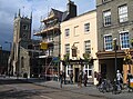 The northeast side of Bridge Street with St Clement's Church in the background. [7]
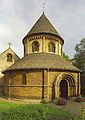 The Holy Sepulchre or "Round Church", on the corner of Bridge Street and Round Church Street.
 The Baron of Beef public house at 19 Bridge Street.


