Bridge of Don (bridge)

Last updated

Bridge of Don
The Bridge of Don - geograph.org.uk - 234494.jpg
The bridge in 2004 (fifth arch not visible)
Coordinates 57°10′32″N2°05′26″W / 57.17548°N 2.09060°W / 57.17548; -2.09060
Carries A956 road
Crosses River Don
LocaleAberdeen, Scotland
Preceded by Brig o' Balgownie
Characteristics
Material Granite
Width66 feet (20 m)
Longest span75 feet (23 m)
No. of spansFive
History
Construction start1827
Construction end1830
Listed Building – Category B
Designated12 January 1967
Reference no. LB20069
Location
Bridge of Don (bridge)

Bridge of Don is a five-arch bridge of granite, built between 1827 and 1830, crossing the River Don just above its mouth in Aberdeen, Scotland.

Contents

History

In 1605 Alexander Hay executed a Charter of Mortification for the maintenance of the 13th century Brig o' Balgownie further upstream, which later became the Bridge of Don Fund, which financed several bridges in the north-east of Scotland. [1] [2] This fund having accumulated a value of over £20,000, the patrons of the fund, the town council, sought an Act of Parliament to permit construction of a new bridge in 1825. [3]

The original design by John Gibb and John Smith was modified by Thomas Telford, and construction work started in 1827. [4] Problems with the foundations meant it had to be partly taken down and have additional piles sunk. [4] It was opened free to the public with no toll in 1830 and later gave its name to the suburb of the city on the north bank. [3] [4] [5]

It was listed as a Category B listed building in 1967. [4] [6]

Design

The two different bridges can be seen here The Bridge of Don - geograph.org.uk - 627664.jpg
The two different bridges can be seen here

The bridge has five spans of dressed granite, and rounded cutwaters that carry up to road level to form pedestrian refuges. [4] The spans are 75 feet (23 m), with a rise of 25 feet (7.6 m). [4]

It was widened in 1958-59, from 24 feet (7.3 m), to 66 feet (20 m) by the construction of a new concrete bridge adjacent to the old one. [4] [7]

It now carries four lanes of the A956 road, and is the last bridge on the River Don before it meets the North Sea. [4] [8] The bridge is just downstream from a substantial island in the river. [8] Around the area of the bridge is the Donmouth Local Nature Reserve, designated as a LNR in 1992. [9] Near to the bridge are a number of World War II era coastal defences, including a pill box. [10]

Related Research Articles

<span class="mw-page-title-main">Brig o' Balgownie</span> 13th century bridge in Aberdeen, Scotland

The Brig o' Balgownie is a 13th-century bridge spanning the River Don in Old Aberdeen, Scotland.

<span class="mw-page-title-main">Old Aberdeen</span> Human settlement in Scotland

Old Aberdeen is part of Aberdeen in Scotland. Old Aberdeen was originally a separate burgh, which was erected into a burgh of barony on 26 December 1489. It was incorporated into adjacent Aberdeen by Act of Parliament in 1891. It retains the status of a community council area.

<span class="mw-page-title-main">Union Chain Bridge</span> Bridge

The Union Chain Bridge or Union Bridge is a suspension bridge that spans the River Tweed between Horncliffe, Northumberland, England and Fishwick, Berwickshire, Scotland. It is four miles (6.4 km) upstream of Berwick-upon-Tweed. When it opened in 1820 it was the longest wrought iron suspension bridge in the world with a span of 449 feet (137 m), and the first vehicular bridge of its type in the United Kingdom. Although work started on the Menai Suspension Bridge first, the Union Bridge was completed first. The suspension bridge, which is a Category A listed building in Scotland, is now the oldest to be still carrying road traffic.

<span class="mw-page-title-main">Bridge of Don</span> Human settlement in Scotland

Bridge of Don is a suburb in the north of Aberdeen, Scotland. In 2020, the Bridge of Don electoral ward was estimated to have a population of 19,545.

<span class="mw-page-title-main">Transport in Aberdeen</span> Overview of transport in Aberdeen

The network of transportation in Aberdeen is extensive and diversified, like that of many comparably sized cities.

<span class="mw-page-title-main">Architecture of Aberdeen</span> Buildings in Aberdeen, Scotland (UK)

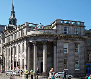
The architecture of Aberdeen, Scotland, is known for the use of granite as the principal construction material. The stone, which has been quarried in and around the city, has given Aberdeen the epithet The Granite City, or more romantically, and less commonly used, the Silver City, after the mica in the stone which sparkles in the sun.

<span class="mw-page-title-main">Bridge of Dee</span>

The Bridge of Dee or Brig o Dee is a road bridge over the River Dee in Aberdeen, Scotland. The term is also used for the surrounding area of the city. Dating from 1527, the bridge crosses at what was once the City of Aberdeen's southern boundary.

<span class="mw-page-title-main">John Smith (architect)</span> Scottish architect (1781–1852)

John Smith was a Scottish architect. His career started in 1805 and he was appointed as the official city architect of Aberdeen in 1807, the first person to hold this post. Together with Archibald Simpson, he contributed significantly to the architecture of Aberdeen, and many of the granite buildings that gave the city the nickname "The Granite City" or also "The Silver City" are attributed to them.

<span class="mw-page-title-main">Slateford Aqueduct</span> Bridge in Slateford

The Slateford Aqueduct is a navigable aqueduct that carries the Union Canal over the Water of Leith at Slateford, Edinburgh, Scotland. Completed in 1822, it has eight arches and spans a length of 500 feet (150 m).

<span class="mw-page-title-main">King Street, Aberdeen</span> Street in Aberdeen, Scotland, United Kingdom

King Street is one of the main streets in the city of Aberdeen, Scotland.

<span class="mw-page-title-main">Aberdeen Harbour</span> Port on the north east coast of Scotland

Aberdeen Harbour, rebranded as the Port of Aberdeen in 2022, is a sea port located in the city of Aberdeen on the east coast of Scotland. The port was first established in 1136 and has been continually redeveloped over the centuries to provide a base for significant fishing and ship building industries. Since the 1970s it has provided support to the offshore oil and gas industry operating in the North Sea and it is the main commercial port in the north east of Scotland.

<span class="mw-page-title-main">Yair Bridge</span> Bridge

The Yair Bridge or Fairnilee Bridge is a bridge across the River Tweed at Yair, near Galashiels in the Scottish Borders.

<span class="mw-page-title-main">River Cart Aqueduct</span> Bridge

The River Cart Aqueduct, sometimes known as the Blackhall Bridge, is a railway bridge and former navigable aqueduct in Paisley, Renfrewshire, Scotland. It opened in 1811 as an aqueduct to carry the Glasgow, Paisley and Johnstone Canal over the White Cart Water. Following the closure of the canal in 1881, it was converted to a railway bridge in 1885, and now carries the Paisley Canal Line. It is registered as a Category A listed building by Historic Environment Scotland.

<span class="mw-page-title-main">Caledonian Railway Bridge</span> Bridge

The Caledonian Railway Bridge is a bridge crossing the River Clyde at Broomielaw in Scotland. It is adjacent to Glasgow Central Station.

<span class="mw-page-title-main">Wellington Suspension Bridge</span>

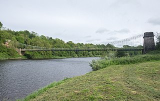
The Wellington Suspension Bridge is a suspension bridge crossing the River Dee from Ferryhill to Craiglug in Aberdeen, north east Scotland. Designed by Captain Samuel Brown and the Aberdeen City Architect John Smith, it was opened to pedestrians in November 1830 and to traffic in May 1831. The chain bridge was closed in 1984 to vehicles and then pedestrians in 2002, but was restored in 2006/07 and pedestrian use was re-instated in 2008.

<span class="mw-page-title-main">Victoria Swing Bridge</span> Bridge

The Victoria Swing Bridge is a swing bridge in Leith, Edinburgh.

<span class="mw-page-title-main">Cambus O' May bridge</span> Bridge in Aberdeenshire, Scotland, UK

The Cambus O' May bridge spans the River Dee to the east of Ballater, Aberdeenshire, Scotland. It was paid for by the estate of Alexander Gordon, who had grown up nearby. The bridge was built in 1905 and is a suspension footbridge 164 feet (50 m) long and 4 feet (1.2 m) wide. The bridge was rebuilt in 1988 for safety reasons but was badly damaged in the December 2015 Storm Frank. It was repaired and reopened in April 2021.

References

  1. "Brig o'Balgownie". engineering-timelines.com. Archived from the original on 13 September 2014. Retrieved 16 September 2014.
  2. Historic Environment Scotland. "Aberdeen, Brig o' Balgownie (20161)". Canmore . Retrieved 16 September 2014.
  3. 1 2 House of Commons Papers. H.M. Stationery Office. 1835. p.  35.
  4. 1 2 3 4 5 6 7 8 Historic Environment Scotland. "Aberdeen, Bridge of Don (20143)". Canmore . Retrieved 16 September 2014.
  5. "Bridge of Don". scottish-places.info. Retrieved 16 September 2014.
  6. Historic Environment Scotland. "Bridge of Don, King Street (Category B Listed Building) (LB20069)" . Retrieved 28 March 2019.
  7. "Major Road Projects". Parliamentary Debates (Hansard) . 13 June 1961. Retrieved 17 September 2014.
  8. 1 2 Google (16 September 2014). "Bridge of Don" (Map). Google Maps . Google. Retrieved 16 September 2014.
  9. "Donmouth Local Nature Reserve". aberdeencity.gov.uk. Archived from the original on 17 September 2014. Retrieved 16 September 2014.
  10. "Aberdeen, Bridge Of Don, Pill Box". scotlandsplaces.gov.uk. Retrieved 17 September 2014.