Related Research Articles

Porthcawl ( ) is a town and community in the Bridgend County Borough of Wales. It is on the south coast of Wales, 25 miles (40 km) west of Cardiff and 19 miles (31 km) southeast of Swansea.

The River Nith is a river in south-west Scotland. The Nith rises in the Carsphairn hills of East Ayrshire, between Prickeny Hill and Enoch Hill, 4.4 miles (7.1 km) east of Dalmellington. For the majority of its 70 miles (110 km) course it flows in a south-easterly direction through Dumfries and Galloway and then into the Solway Firth at Airds Point.

Pilsey Island is a 17.8-hectare (44-acre) Local Nature Reserve in Chichester Harbour in West Sussex. It is owned by the Ministry of Defence and managed by the Royal Society for the Protection of Birds. It is part of the Chichester Harbour Site of Special Scientific Interest and Nature Conservation Review site, Grade I*, the Chichester and Langstone Harbours Ramsar site and Special Protection Area, and the Solent Maritime Special Area of Conservation.

The Rinns of Islay is an area on the west of the island of Islay in the Inner Hebrides of Scotland.

The A847 road is one of the two principal roads of Islay in the Inner Hebrides off the west coast of mainland Scotland.
The A846 road is one of the two principal roads of Islay in the Inner Hebrides off the west coast of mainland Scotland and the only 'A' road on the neighbouring island of Jura.

The Rokel River is the largest river in the Republic of Sierra Leone in West Africa. The river basin measures 10,622 km2 (4,101 sq mi) in size, with the drainage divided by the Gbengbe and Kabala hills and the Sula Mountains. The estuary which extends over an area of 2,950 km2 (1,140 sq mi) became a Ramsar wetland site of importance in 1999.

Old Crow Flats is a 6,170 km2 (2,382 sq mi) wetland complex in northern Yukon, Canada along the Old Crow River. It is north of the Arctic Circle and south of the Beaufort Sea, and is nearly surrounded by mountains.
Kilchoman is a small settlement and large parish on the Scottish island of Islay, within the unitary council of Argyll and Bute.
Loch Gruinart is a sea loch on the northern coast of isle of Islay in Scotland. Land at the head of the loch, Gruinart Flats, is a designated nature reserve owned by the RSPB. It is an important winter roosting site for barnacle geese. Ardnave Point is a coastal promontory near the mouth of the loch on the northwest of Islay.

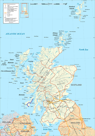
Islay is the southernmost island of the Inner Hebrides of Scotland. Known as "The Queen of the Hebrides", it lies in Argyll just south west of Jura and around 40 kilometres north of the Northern Irish coast. The island's capital is Bowmore where the distinctive round Kilarrow Parish Church and a distillery are located. Port Ellen is the main port.

Bahia Lomas is a bay in the eastern mouth of the Strait of Magellan in Southern Chile, on the north coast of the Isla Grande de Tierra del Fuego. The area is a large tidal plain, with a tidal variation up to 7 km. The wetlands of the bay are important sites for the red knot, the Hudsonian godwit and other shorebirds. The wetlands are a Ramsar site of international importance and an Important Bird Area.

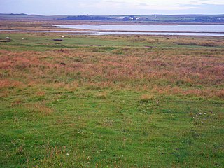
The Gruinart Flats is a low-lying landform on the western part of the isle of Islay in Scotland. The locale is an important conservation area, having been designated as an SSSI. Much of the Gruinart Flats is a marshy area operated by the Royal Society for the Protection of Birds. This vicinity is known to be an early habitation site by Mesolithic peoples.

The River Sorn is a small river on the Scottish island of Islay. Draining Loch Finlaggan and having gathered the waters of the Allt Ruadh and the Ballygrant Burn, it flows southwestwards to enter the sea at the village of Bridgend at the head of Loch Indaal.

Dun Nosebridge is an Iron Age fort southeast of Bridgend, Islay, Scotland. The fort is on the right bank of the River Laggan.
Eilean na Muice Duibhe, also known as Duich Moss, is an area of low-level blanket mire on the island of Islay, off the west coast of Scotland. Located south of the town of Bowmore and with an area of 576 hectares, the area has been protected as a Ramsar Site since 1988.

Loch of Lintrathen is a man-made loch occupying a glacial basin at the southern end of Glen Isla, approximately 13 kilometres (8.1 mi) west of town of Kirriemuir in Angus, Scotland.

The Kench, Hayling Island is a 6-hectare (15-acre) Local Nature Reserve on Hayling Island in Hampshire. It is owned by Hampshire County Council and managed by Hampshire Countryside Service. It is part of Chichester and Langstone Harbours Ramsar site and Special Protection Area, Solent Maritime Special Area of Conservation and Langstone Harbour Site of Special Scientific Interest.

Ardnahoe distillery is a Scotch whisky distillery on Islay, in Scotland.
References
- ↑ "Bridgend Flats, Islay". Ramsar Sites Information Service. Retrieved 25 January 2019.
- ↑ "Bridgend Flats, Islay". Joint Nature Conservation Committee . Retrieved 25 January 2019.
55°46′37″N6°15′49″W / 55.77687°N 6.26349°W
| | This Scottish location article is a stub. You can help Wikipedia by expanding it. |