This article includes a list of general references, but it lacks sufficient corresponding inline citations .(November 2021) |
There are seven bridges in and around Drogheda, Ireland.
This article includes a list of general references, but it lacks sufficient corresponding inline citations .(November 2021) |
There are seven bridges in and around Drogheda, Ireland.
The Mary McAleese Boyne Valley Bridge is Ireland's longest cable-stayed bridge, located 3.1 kilometres west of Drogheda.

The Boyne Viaduct is a railway bridge that crosses the River Boyne in Drogheda, carrying the main Dublin–Belfast railway line.
The Bridge of Peace is the second-furthest-west bridge in Drogheda. It was built as a part of an inner by-pass of the town in the 1970s.
Dominic's Bridge is one of the closest bridges to Drogheda's town centre. It was manufactured by Grendons of Drogheda in 1863. [1] It is now a pedestrian bridge, one of two in Drogheda, but was previously also used by motor-vehicles until its replacement by "The Bridge of Peace" in the 1970s.

The de Lacy Bridge is one of two pedestrian bridges in Drogheda. It was part of phase one of the Scotch Hall development on the south side of the river. There is a plaque on the bridge indicating it was unveiled on 10 November 2005 by Tommy Murphy, the then mayor of Drogheda. [2]
St. Mary's Bridge is the main bridge to the centre of Drogheda. It was, for hundreds of years, the site of the only bridge at Drogheda. It is at the meeting of the two major south side roads the N51 and the Marsh Road. The bridge was reconstructed in precast prestressed concrete by the Office of Public Works in 1983, replacing a masonry two-arch structure designed by John Neville, County surveyor for Co. Louth, which was built between 1863 and 1868.
This bridge is also a major bridge in Drogheda. It is flanked by a McDonald's restaurant, Xtra-vision store and a health centre on the south side. On the north side: Haymarket car park and a block of apartments. As of 2023, it received an upgrade to accommodate the new and upcoming Westgate Vision.

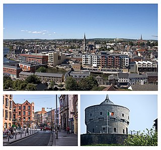
Drogheda is an industrial and port town in County Louth on the east coast of Ireland, 56 km (35 mi) north of Dublin. It is located on the Dublin–Belfast corridor on the east coast of Ireland, mostly in County Louth but with the south fringes of the town in County Meath, 49 km (30 mi) north of Dublin. Drogheda had a population of 44,135 inhabitants in 2022, making it the eleventh largest settlement by population in all of Ireland, and the largest town in the Republic of Ireland by both population and area. It is the last bridging point on the River Boyne before it enters the Irish Sea. The UNESCO World Heritage Site of Newgrange is located 8 km (5.0 mi) west of the town.

Slane is a village in County Meath, in Ireland. The village stands on a steep hillside on the left bank of the River Boyne at the intersection of the N2 and the N51. As of the 2022 census, Slane's population was 1,445. The village and surrounding area contains many historic sites dating back over 5,000 years. The village centre, as it is laid-out today, dates mainly from the 18th century.

The River Boyne is a river in Leinster, Ireland, the course of which is about 112 kilometres (70 mi) long. It rises at Trinity Well, Newberry Hall, near Carbury, County Kildare, and flows towards the Northeast through County Meath to reach the Irish Sea between Mornington, County Meath, and Baltray, County Louth.

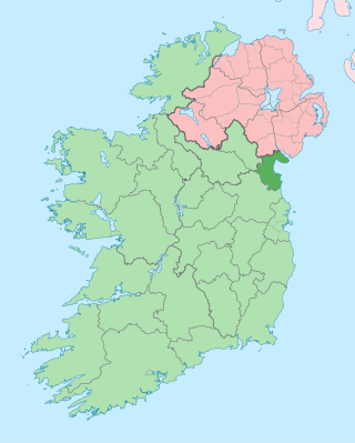
County Louth is a coastal county in the Eastern and Midland Region of Ireland, within the province of Leinster. Louth is bordered by the counties of Meath to the south, Monaghan to the west, Armagh to the north and Down to the north-east, across Carlingford Lough. It is the smallest county in Ireland by land area and the 17th most populous, with just over 139,100 residents as of 2022. The county is named after the village of Louth. Louth County Council is the local authority for the county.

Sir John Benjamin Macneill FRS was an eminent Irish civil engineer of the 19th century, closely associated with Thomas Telford. His most notable projects were railway schemes in Ireland.

The Boyne Viaduct, a 30-metre-high (98 ft) railway bridge, or viaduct, that crosses the River Boyne in Drogheda, carrying the main Dublin–Belfast railway line.

Millmount is a large fortified complex situated on a great mound on the South bank of the River Boyne located in Drogheda, County Louth, Ireland. The fort has played a crucial part in Drogheda's history and has been a dominant feature from Norman settlement, to Cromwell's invasion to the more recent Civil War in 1922, in which the famous Martello tower was shelled and all but destroyed. Today the complex houses the Millmount Museum which houses a wide variety of artifacts of local and national importance. The complex is Drogheda's most dominant feature, clearly visible from all parts of the town. The Martello tower is affectionately known as "The Cup and Saucer" by locals. The whole fort is a national monument and has been designated as Drogheda's Cultural Quarter.

The Mary McAleese Boyne Valley Bridge is a cable-stayed bridge in County Meath, and County Louth, Ireland. It spans the Boyne River 3 kilometres (1.9 mi) west of Drogheda on the county boundary between County Meath and County Louth and is part of the M1 Northern Motorway. When it opened in June 2003, it was the longest cable-stayed bridge in Ireland until 19 October 2009, when the River Suir Bridge opened on the N25.

Brú na Bóinne, also called the Boyne Valley tombs, is an ancient monument complex and ritual landscape in County Meath, Ireland, located in a bend of the River Boyne. It is one of the world's most important Neolithic landscapes, comprising at least ninety monuments including passage tombs, burial mounds, standing stones and enclosures. The site is dominated by the passage tombs of Newgrange, Knowth and Dowth, built during the 32nd century BC. Together these have the largest assemblage of megalithic art in Europe. The associated archaeological culture is called the "Boyne culture".

Laytown is a village in County Meath, Ireland, located on the R150 regional road and overlooking the Irish Sea. Historically it was called Ninch, after the townland it occupies. Together with the neighbouring villages of Mornington, Bettystown and Donacarney, it comprises the census town of Laytown–Bettystown–Mornington–Donacarney, which recorded a population of 15,642 in the 2022 census.

Drogheda MacBride railway station serves Drogheda in County Louth, Ireland.

The Boyne Navigation is a series of canals running 31 km (19 mi) roughly parallel to the River Boyne from Oldbridge to Navan in County Meath, in Ireland. The navigation was once used by horse-drawn boats travelling between Navan, Slane and the port of Drogheda; however is now derelict. The Boyne Navigation branch of the Inland Waterways Association of Ireland have an agreement with An Taisce – The National Trust for Ireland giving it a license to carry out restoration work on the navigation to return it to a usable waterway.

Dublin and Drogheda Railway (D&D) was a railway company in Ireland which publicly opened its 31¾ mile main line between Dublin and Drogheda in May 1844. It was the third railway company in Ireland to operate passenger trains and the first to use the Irish standard 5 ft 3 in gauge. It later opened branches to Howth and Oldcastle. The opening of the Dublin and Belfast Junction Railway (D&BJct) between the D&D at Drogheda and the Ulster Railway (UR) at Portadown in 1852 saw an almost continuous main line connection between Dublin and Belfast, which was resolved by the official opening of the Boyne Viaduct in April 1855. Amalgamations between these and other companies in 1875 and 1876 saw the creation of the Great Northern Railway of Ireland GNR(I).

Mornington is a coastal village on the estuary of the River Boyne in County Meath, Ireland approximately 5 km downriver from the centre of Drogheda. Together with the neighbouring villages of Laytown, Bettystown and Donacarney, it comprises the urban area of Laytown–Bettystown–Mornington–Donacarney with a combined population of 15,642 at the 2022 census.


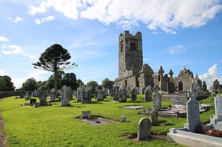
Donore, historically Dunower, is a small village in County Meath, Ireland. It lies near Drogheda on the border between County Meath and County Louth, in the Boyne Valley on the road between Drogheda and the Brú na Bóinne heritage site. During the late 17th century, the village was used as a defensive position by the Jacobite army of King James II against King William III during the Battle of the Boyne (1690). The Battle of the Boyne Visitor Centre is located in the restored 18th century Oldbridge House, which is on the battle site, approximately 3 km north of Donore.
Drogheda was a constituency represented in the Irish House of Commons to 1801.

Wolfe Tones GFC is a Gaelic Football club from Drogheda, County Louth, Ireland. It serves the residents of St Mary's Parish in south Drogheda and fields Gaelic football teams in competitions organised by Louth GAA. One of the oldest GAA clubs in Louth, Wolfe Tones play gaelic football at all age levels from nursery to adult.

Thomas Grendon and Company was an engineering company established in 1835 based in Grendons Foundry and Engineering Works, South Quay, Drogheda, Ireland.

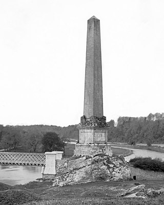
The Boyne Obelisk, also known as King William's Obelisk, was an obelisk located in Oldbridge, near Drogheda, County Louth, Ireland.