
Brighouse is a town within the metropolitan borough of Calderdale, in West Yorkshire, England. Historically within the West Riding of Yorkshire, it is situated on the River Calder, 4 miles (6.4 km) east of Halifax. It is served by Junction 25 of the M62 motorway and Brighouse railway station on the Caldervale Line and Huddersfield Line. In the town centre is a mooring basin on the Calder and Hebble Navigation. The United Kingdom Census 2001 gave the Brighouse / Rastrick subdivision of the West Yorkshire Urban Area a population of 32,360. The Brighouse ward of Calderdale Council gave a population of 11,195 at the 2011 Census. Brighouse has a HD6 postcode.

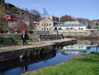
The Calder and Hebble Navigation is a broad inland waterway, with locks and bridge holes that are suitable for 14-foot-wide (4.3 m) boats, in West Yorkshire, England. Construction to improve the River Calder and the River Hebble began in 1759, and the initial scheme, which included 5.7 miles (9.2 km) of new cuts, was completed in 1770 and has remained navigable since it was opened. Significant improvements were made, including the Salterhebble branch to Halifax, opened in 1828, and ever-longer cuts to bypass river sections. Trade was assisted by the opening of the Rochdale Canal in 1804, which provided a through route from Sowerby Bridge to Manchester. There were plans to abandon the river sections completely in the 1830s, but these were modified as the needs of mill owners and other riparian landowners were recognised.

Rastrick is a village in the county of West Yorkshire, England, between Halifax, 5 miles (8 km) north-west and Huddersfield, 4 miles (7 km) south.

Sowerby Bridge is a market town in the Upper Calder Valley in Calderdale in West Yorkshire, England. The Calderdale Council ward population at the 2011 census was 11,703.

Calderdale is a metropolitan borough of West Yorkshire, England, which had a population of 211,439. It takes its name from the River Calder, and dale, a word for valley. The name Calderdale usually refers to the borough through which the upper river flows, while the actual landform is known as the Calder Valley. Several small valleys contain tributaries of the River Calder. The main towns of the borough are Brighouse, Elland, Halifax, Hebden Bridge, Sowerby Bridge and Todmorden.

The Huddersfield Broad Canal or Sir John Ramsden's Canal, is a wide-locked navigable canal in West Yorkshire in northern England. The waterway is 3.75 miles (6 km) long and has 9 wide locks. It follows the valley of the River Colne and connects the Calder and Hebble Navigation at Cooper Bridge junction with the Huddersfield Narrow Canal near Aspley Basin in Huddersfield.

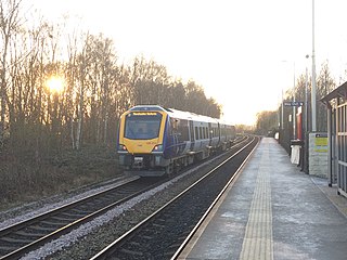
The Calder Valley line is a railway route in Northern England between the cities of Leeds and Manchester as well as the seaside resort of Blackpool. It is the slower of the two main rail routes between Leeds and Manchester, and the northernmost of the three main trans-Pennine routes.
Halifax railway station serves the town of Halifax in West Yorkshire, England. It lies on the Calder Valley line and is 17 miles (27 km) west from Leeds.
Bramley railway station serves the suburb of Bramley, Leeds, England. It lies on the Calder Valley line 4 miles (6 km) west from Leeds.
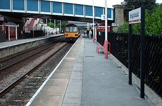
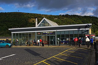
Brighouse railway station serves the town of Brighouse in West Yorkshire, England. The station lies on the Calder Valley line running west from Leeds. Opened in 1840, and closed in 1970, it reopened in 2000 and is served by Northern Trains and Grand Central services.

Mirfield railway station serves the town of Mirfield in West Yorkshire, England. It lies on the Huddersfield Line and is managed by Northern and also receives services by Grand Central and also TransPennine Express. The station is 4 miles (6 km) north east from Huddersfield.
Salterhebble is an area of Halifax, a town within the Metropolitan Borough of Calderdale, in West Yorkshire, England. The town falls within the Skircoat ward of Calderdale Council. Salterhebble is located where the Hebble Brook flows into the River Calder. It is on the main route into Halifax from Huddersfield and Brighouse. Salterhebble is the home of Calderdale Royal Hospital, a school, a fast food restaurant, a funeral parlour and one active pub, The Watermill. Some former pubs in the village included The Punch Bowl, The Falcon and The Stafford Arms.

The A643 is a main road between Leeds and Huddersfield in West Yorkshire, England. Its eastern end is at the Armley Gyratory roundabout on the western edge of Leeds City Centre. The road then goes through:

Bradley railway station served the district of Bradley, West Yorkshire, England until closure in 1950.

The Pickle Bridge line is a disused railway route in Northern England that ran between Huddersfield and Bradford.

The River Calder is a river in West Yorkshire, in Northern England.
Brighouse is a town and an unparished area in the metropolitan borough of Calderdale, West Yorkshire, England. It contains 71 listed buildings that are recorded in the National Heritage List for England. Of these, two are listed at Grade I, the highest of the three grades, six are at Grade II*, the middle grade, and the others are at Grade II, the lowest grade. This list contains the listed buildings in Brighouse Ward which, in addition to the town of Brighouse, contains the village of Clifton and the surrounding countryside, in particular to the west and the southeast of the town along the valley of the River Calder. Historically, one of the most important buildings in the area was Kirklees Priory, which has been demolished, but listed buildings associated with it remain, in particular farm buildings in Home Farm and a gatehouse. In addition to the River Calder, the Calder and Hebble Navigation runs through the area, and listed buildings associated with the two waterways include bridges, locks, lock keepers' houses, a warehouse, and a milestone. The other listed buildings include houses and associated structures, cottages, farmhouses and farm buildings, shops and offices, churches and chapels, two graves, a sundial, a former mill, a former school, civic buildings, banks, a railway bridge, road milestones, a boundary stone, a folly, and a war memorial.
This is a list of turnpike trusts that maintained roads in Yorkshire.

