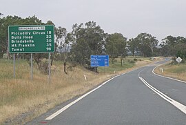
Monaro Highway is a 285-kilometre-long (177 mi) highway in Victoria, New South Wales, and the Australian Capital Territory, in Australia, linking Cann River in Victoria to Canberra in the Australian Capital Territory (ACT) via the Monaro region. From its southern terminus, it follows the nearby Cann River upstream towards the New South Wales border through heavily forested terrain. Within New South Wales (NSW), it makes its way through further forest before reaching the pastures typical of the Monaro. There are multiple towns and villages along the highway, including Bombala, Nimmitabel, and Cooma. The terrain within the Monaro is largely hilly, and there are numerous crossings. The road also parallels the former Bombala railway line in several locations. Within the ACT, the road becomes a high volume roadway and serves the southern suburbs of Canberra. The highway has more recently had a grade-separated dual carriageway extension constructed within Canberra, as part of the Eastern Parkway construction project. It is designated part of route M23, and route A23 within Canberra, and route B23 within Victoria and New South Wales, with a concurrency where it also carries route B72 between the two sections of Snowy Mountains Highway.

Snowy Mountains Highway is a 333-kilometre-long (207 mi) state highway located in New South Wales, Australia. Its two sections connect the New South Wales South Coast to the Monaro region, and the Monaro to the South West Slopes via the Snowy Mountains. The higher altitude regions of this road are subject to snow over the winter months, and the road also provides access to many parts of the Snowy Mountains Scheme. The highway bears the B72 shield along its entire length.

The 2003 Canberra bushfires caused severe damage to the suburbs and outer areas of Canberra, the capital city of Australia, during 18–22 January 2003. Almost 70% of the Australian Capital Territory's (ACT) pastures, pine plantations, and nature parks were severely damaged, and most of the Mount Stromlo Observatory was destroyed. After burning for a week around the edges of the ACT, the fires entered the suburbs of Canberra on 18 January 2003. Over the next ten hours, four people died, over 490 were injured, and 470 homes were destroyed or severely damaged, requiring a significant relief and reconstruction effort.

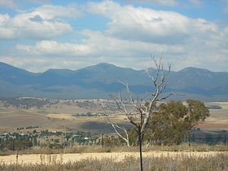
The Brindabella Range, commonly called The Brindabellas or The Brindies, is a mountain range located in Australia, on a state and territory border of New South Wales and the Australian Capital Territory (ACT). The range rises to the west of Canberra, the capital city of Australia, and includes the Namadgi National Park in the ACT and the Bimberi Nature Reserve and Brindabella National Park in New South Wales. The Brindabellas are visible to the west of Canberra and form an important part of the city's landscape.

Cabramurra was the third-highest permanently inhabited town on the Australian continent, situated at 1,488 metres (4,882 ft) in the western Snowy Mountains of the Great Dividing Range, in the state of New South Wales. It is 82 metres (269 ft) lower than Dinner Plain in Victoria, and 272 metres (892 ft) lower than Charlotte Pass Village in New South Wales. The last residents are scheduled to leave the town in January 2018 with the current workforce housed being replaced with drive-in/drive-out staff. The name Cabramurra may be derived from Wiradjuri gambirra marra.
The District of Weston Creek is one of the original eighteen districts of the Australian Capital Territory used in land administration. The district is subdivided into divisions (suburbs), sections and blocks. The district of Weston Creek lies entirely within the bounds of the city of Canberra, the capital city of Australia. The district comprises eight residential suburbs, situated to the west of the Woden Valley district and approximately 13 kilometres (8.1 mi) southwest of the Canberra City centre. Situated adjacent to the district was the large Stromlo Forest pine plantation until the forest was destroyed by bushfires in 2001 and 2003.

Tumut is a town in the Riverina region of New South Wales, Australia, situated on the banks of the Tumut River.
Michelago is a village in the Monaro region of New South Wales, Australia. The village is in the Snowy Monaro Regional Council local government area, 54 kilometres (34 mi) south of Canberra on the Monaro Highway. It was founded in the 1820s, on the main route from Sydney to the Snowy Mountains. At the 2016 census, Michelago had a population of 562.

The Cotter River, a perennial river of the Murrumbidgee catchment within the Murray–Darling basin, is located in the Australian Capital Territory, Australia. The Cotter River, together with the Queanbeyan River, is one of two rivers that provides potable water to the Canberra and Queanbeyan region.
Uriarra Village is a community in the District of Coree, Australian Capital Territory established in 1928 at the foothills of the Australian Alps. A nearby area to the north of the border in New South Wales is also called Uriarra.
The history of the Australian Capital Territory (ACT) as a separate administrative division began in 1911, when it was transferred from New South Wales to the Australian federal government. The territory contains Australia's capital city Canberra and various smaller settlements. Until 1989, it also administered the Jervis Bay Territory, a small coastal region.

Wee Jasper is a hamlet in the Goodradigbee valley at the western foot of the Brindabella Ranges, near Burrinjuck Dam in New South Wales, Australia in Yass Valley Shire. It is located about 90 km north-west of Canberra and 60 km south-west of Yass. At the 2021 census, Wee Jasper and the surrounding area had a population of 127.

The Brindabella Valley is a valley situated below the western ridge-line of the Brindabella Range, located midway along the Goodradigbee River, in the south of New South Wales, Australia.
Mount Coree is a mountain with an elevation of 1,421 metres (4,662 ft) AHD that is located within the Brindabella Range on the border between the Australian Capital Territory and New South Wales, Australia. The summit of the mountain is located in the Australian Capital Territory.

Mount Gingera is a mountain with an elevation of 1,857 metres (6,093 ft) AHD located within the Brindabella Range on the border between the Australian Capital Territory and New South Wales in Australia. The summit of the mountain is located within the ACT, and is the second highest peak in the territory.
Brindabella is a locality in south-east New South Wales, Australia, mainly in the area of Snowy Valleys Council and partly in Yass Valley Council. It is reached by the Brindabella Road from the Australian Capital Territory over the Brindabella Ranges. It is significant as the early home of Miles Franklin, who wrote a well known book called Childhood at Brindabella. It had a population of 22 at the 2016 census, who live in the Brindabella Valley. The locality also includes a large unpopulated area consisting of parts of the Brindabella National Park, the Kosciuszko National Park and the Bimberi Nature Reserve and of state forests.
Mount Franklin is a mountain with an elevation of 1,646 metres (5,400 ft) AHD in the Brindabella Ranges that is located on the border between the Australian Capital Territory and New South Wales, Australia. The summit of the mountain is located in the Australian Capital Territory.

Skiing in the Australian Capital Territory refers to snow skiing in the Australian Capital Territory (ACT). The highest mountain in the ACT is Bimberi Peak. Recreational skiing commenced with the formation of the Canberra Alpine Club in 1934. Since the 1930s, the ACT has had intermittent and limited alpine skiing facilities. Downhill ski facilities returned to the ACT at Corin Forest in 2016, after a two decade hiatus.

The ACT Rural Fire Service is a branch of the Australian Capital Territory Emergency Services Agency. It is responsible for the prevention, detection and extinguishment of all bushfires within the ACT, as well as assisting the other branches of ESA.

The Snowy Valleys Council is a local government area located in the South West Slopes region of New South Wales, Australia. This area was formed in 2016 from the merger of the Tumut Shire with the neighbouring Tumbarumba Shire.