
Cannock Chase, often referred to locally as The Chase, is a mixed area of countryside in the county of Staffordshire, England. The area has been designated as the Cannock Chase National Landscape, an Area of Outstanding Natural Beauty, and much of it is managed by Forestry England for its important ecology and for recreational use. The Chase gives its name to the Cannock Chase local government district. It is a former Royal forest.

Cannock is a town in the Cannock Chase district in the county of Staffordshire, England. It had a population of 29,018. Cannock is not far from the towns of Walsall, Burntwood, Stafford and Telford. The cities of Lichfield and Wolverhampton are also nearby.

Rugeley is a market town and civil parish in the Cannock Chase District, in Staffordshire, England. It lies on the north-eastern edge of Cannock Chase next to the River Trent; it is situated 8 miles (13 km) north of Lichfield, 10 miles (16 km) south-east of Stafford, 5 miles (8.0 km) north-east of Hednesford and 11 miles (18 km) south-west of Uttoxeter. At the 2021 Census, the population was 26,156.

Handsacre is a village in the English county of Staffordshire. Population details taken at the 2011 census can be found under Armitage with Handsacre
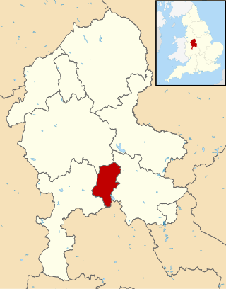
Cannock Chase is a local government district in Staffordshire, England. It is named after and covers a large part of Cannock Chase, a designated National Landscape. The council is based in the town of Cannock. The district also contains the towns of Hednesford and Rugeley, as well as a number of villages and surrounding rural areas.

Lichfield District is a local government district in Staffordshire, England. The district is named after its largest settlement, the city of Lichfield, which is where the district council is based. The district also contains the towns of Burntwood and Fazeley, along with numerous villages and surrounding rural areas, including part of Cannock Chase, a designated Area of Outstanding Natural Beauty.

Hednesford is a market town and civil parish in the Cannock Chase district of Staffordshire, England. The Cannock Chase area of natural beauty is to the north of the town. Hednesford is also 1 mile (1.6 km) to the north of Cannock and 5 miles (8.0 km) to the south of Rugeley. The population at the 2011 census was 17,343.
Pye Green is an English village on Cannock Chase in the south of Staffordshire standing nearly 800 feet above sea-level, literally overlooking Hednesford, Cannock, Walsall and much of the Black Country. Birmingham city centre can be clearly seen when the weather is good.

The Chase Line is a suburban railway line in the West Midlands region of England. It runs from its southern terminus, Birmingham International, to Walsall, and then Rugeley Trent Valley in Staffordshire, where it joins the Trent Valley line. The name of the line refers to Cannock Chase which it runs through at its northern end.

Cannock Chase is a constituency in Staffordshire represented in the House of Commons of the UK Parliament since 2024 by Josh Newbury of the Labour Party.

Brocton is a village and civil parish in the English county of Staffordshire. It is within the borough of Stafford. The village describes itself as the Gateway to Cannock Chase, an Area of Outstanding Natural Beauty and a Site of Special Scientific Interest.

Brereton is a village and former civil parish, now in the parish of Brereton and Ravenhill, in the Cannock Chase district, in the county of Staffordshire, England.
Cannock Wood is a village and civil parish in the Cannock Chase district of Staffordshire, England. The village is situated around 4 miles (6.4 km) east of Cannock, the same distance south of Rugeley, and 2 miles (3.2 km) north of Burntwood. According to the 2011 Census, the parish had a population of 1,031, a decrease from 1,052 in the 2001 Census.

Cheslyn Hay is a former mining village and civil parish in the South Staffordshire district of Staffordshire, England. It is 3 miles south of Cannock, 10 miles north of Walsall, 9 miles northeast of Wolverhampton, and 13 miles south of Stafford. The village forms a built-up area with the villages and areas of Great Wyrley, Landywood, and Churchbridge.
The A460 is a main road in the Midlands of England. It runs from Wolverhampton in the West Midlands to Rugeley in Staffordshire. It is also a primary road linking Wolverhampton and Cannock with the M54, M6 and M6 Toll.
Royal Air Force Hednesford or more simply RAF Hednesford is a former Royal Air Force station situated 7.5 miles (12.1 km) south-east of Stafford, Staffordshire, England.

Heath Hayes and Wimblebury is a civil parish in the Cannock Chase District of Staffordshire, England. It comprises the once separate villages of Heath Hayes and Wimblebury, which following recent housing development have now become joined. It is one of the most affluent areas in the borough, being home to several good schools and being popular with commuters due to the excellent transport links - with both Cannock and Hednesford train stations nearby and also being close to the M6, M6 toll and A5. It has also seen the recent development of the McArthur Glen designer outlet West Midlands and is situated directly adjacent to Cannock Chase area of outstanding natural beauty (AONB).
Valley Colliery, commonly known as Valley Pit, was a deep coal mine and training centre located in Hednesford, Staffordshire, UK.

Hazelslade is a former mining village in Staffordshire, England. It is now part of Cannock Chase District. The village is located between Hednesford and Rugeley. It has been built into the Rawnsley area of Hednesford and is now effectively a suburban village of Hednesford. The village has a post office, a freehouse and housing estates. There was also a former mineral railway which ran from Hednesford to Burntwood. It can be seen from Google Maps as rows of trees curving around the former mining village and parts of Cannock Chase District to the Chase Line. There is also a bus service which connects the village to Cannock and Burntwood. The nearest mainline railway station is Hednesford. The pub is also named the Hazelslade. The nearest churches are in Church Hill and Hednesford.
