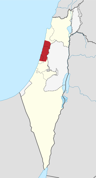
The Sharon plain is the central section of the Israeli coastal plain. The plain lies between the Mediterranean Sea to the west and the Samarian Hills, 15 km (9.3 mi) to the east. It stretches from Nahal Taninim, a stream marking the southern end of Mount Carmel in the north, to the Yarkon River in the south, at the northern limit of Tel Aviv, over a total of about 90 km (56 mi). The level of the Sharon plain is connected to the level of the Mediterranean Sea by the Sharon Escarpment.

The Central District of Israel is one of six administrative districts, including most of the Sharon region. It is further divided into 4 sub-districts: Petah Tikva, Ramla, Sharon, and Rehovot. The district's largest city is Rishon LeZion. The district's population as of 2017 was 2,115,800. According to the Israeli Central Bureau of Statistics, 88% of the population is Jewish, 8.2% is Arab, and 4% are “non-classified”, being mostly former Soviet Union immigrants of partial or nominal Jewish ethnic heritage or household members of Jews.

Ramot, also known as Ramot Alon, is an Israeli settlement in East Jerusalem. Ramot is one of Jerusalem's so-called "Ring settlements". The land was annexed by Israel 13 years after the Six-Day War. As part of Ramot was established in East Jerusalem, the international community considers it an Israeli settlement. The international community considers Israeli settlements in East Jerusalem illegal under international law, but the Israeli government disputes this.

The Victor Valley is a valley in the Mojave Desert and subregion of the Inland Empire, in San Bernardino County in Southern California.

Canada Park is an Israeli national park stretching over 7,000 dunams (7km2), and extending from No man's land into the West Bank. The park is located north of Highway 1, and is situated near the Ayalon Valley, between the Latrun Interchange and Sha'ar HaGai.

The Israel National Trail is a hiking path that was inaugurated in 1995. The trail crosses the entire country of Israel. Its northern end is at Dan, near the Lebanese border in the far north of the country, and it extends to Eilat at the southernmost tip of Israel on the Red Sea, a length of 1,015 km (631 mi).

Bloomfield Stadium is a football stadium in Tel Aviv, Israel, with a capacity of 29,400. It is the home stadium of Maccabi Tel Aviv, Hapoel Tel Aviv, and Bnei Yehuda Tel Aviv. The stadium also serves the Israel national football team for some select home matches.
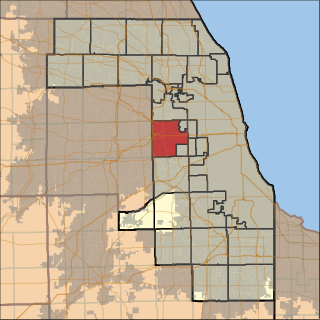
Proviso Township is one of 29 townships in Cook County, Illinois, United States. As of the 2020 census, its population was 151,209. It was organized in 1850 and originally named "Taylor", but shortly afterward its name was changed to make reference to the Wilmot Proviso, a contemporary piece of legislation intended to stop the spread of slavery.
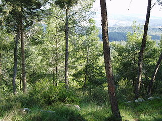
Eshtaol Forest is a forest in Israel, located north of Beit Shemesh and near Ta'oz and Neve Shalom, south of the Tel Aviv-Jerusalem Highway. The Forest of the Martyrs lies to the east. The forest is a popular recreation area and is one of the largest forests in Israel.

Highway 44 is an arterial road in central Israel. It connects Tel Aviv-Yafo and Holon to Ramla, Lod and the Shefela. It is numbered as a north–south road and follows a north-west to south-east path.

Neot Kedumim, the Biblical Landscape Reserve in Israel is a Biblical garden and nature preserve located near Modi'in, midway between Jerusalem and Tel Aviv, Israel.
Tzamarot Ayalon is a neighborhood of Tel Aviv, Israel, on the east-central side of the city. It is ranked as the wealthiest neighborhood in Israel.

The Jerusalem Forest is a municipal pine forest located in the Judean Mountains on the outskirts of Jerusalem. It is surrounded by the neighborhoods of Beit HaKerem, Yefe Nof, Ein Kerem, Har Nof and Givat Shaul, and a moshav, Beit Zeit. The forest was planted during the 1950s by the Jewish National Fund, financed by private donors.

Nahal Alexander, called NaharIskandar in Arabic, is a river in the States of Palestine and Israel that flows from the western side of the Samaria mountain belt in the West Bank to the Mediterranean Sea, north of Netanya. The length of the river is about 45 km. Several small streams flow into Nahal Alexander: Nablus, Te'enim, Ometz, Bahan, and Avihail. The river is the habitat of soft-shell turtles that can reach a size of 1.20 meters.

HaSharon Park is an Israeli national park located alongside Highway 4 with the entrance to it going through the Hadera West Railway Station.

The Australian Soldier Park, in Beersheba, Israel is dedicated to the memory of the Australian Light Horse regiments, that captured the town from the Ottoman Empire during World War I.

Nof Zion is a Jewish religious neighborhood and an Israeli settlement inside of the Palestinian Arab neighborhood of Jabel Mukaber, East Jerusalem.

Superland is an amusement park in Rishon LeZion, Israel. Superland covers an area of about 19.8 acres (8.0 ha) and has three roller coasters, three wet and dry facilities, a cablecar, and a bungee jumping "Skycoaster."

Adullam-France Park, also known as Parc de France-Adoulam, is a sprawling park of 50,000 dunams (ca. 12,350 acres) in the Central District of Israel, located south of Beit Shemesh. The park, established in 2008 for public recreation, features two major hiking and biking trails, and four major archaeological sites from the Second Temple period. It stretches between Naḥal Ha-Elah, its northernmost boundary, to Naḥal Guvrin, its southernmost boundary. To its west lies the Beit Guvrin-Beit Shemesh highway, and to its east the "green line" – now territories under joint Israeli-Palestinian Arab control – which marks its limit.

Ben Shemen Forest is the largest forest in central Israel and one of the largest in the entire country, covering an area of 22,000 dunams. In the forest there are picnic spots, hiking and bicycle routes. It is located on both sides of Route 443, between the Ben Shemen Interchange and the city of Modi'in-Maccabim-Re'ut. The first trees were planted by the Jewish National Fund in 1908.
