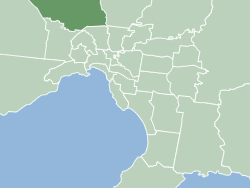
The City of Hume is a local government area located within the metropolitan area of Melbourne, Victoria, Australia. It includes the outer north-western suburbs and a number of rural localities between 13 and 40 kilometres from the Melbourne city centre.

Broadmeadows is a suburb in Melbourne, Victoria, Australia, 15 km (9.3 mi) north of Melbourne's Central Business District and the council seat of the City of Hume local government area. Broadmeadows recorded a population of 12,524 at the 2021 census.

Campbellfield is a suburb in Melbourne, Victoria, Australia, 13 km (8.1 mi) north of Melbourne's Central Business District, located within the City of Hume local government area. Campbellfield recorded a population of 4,977 at the 2021 census.
Craigieburn is a suburb in Melbourne, Victoria, Australia, 25 km (16 mi) north of Melbourne's Central Business District, located within the City of Hume local government area. Craigieburn recorded a population of 66,146 at the 2021 census.

Coolaroo is a suburb in Melbourne, Victoria, Australia, 18 km (11 mi) north of Melbourne's Central Business District, located within the City of Hume local government area. Coolaroo recorded a population of 3,193 at the 2021 census.

Greenvale is a suburb in Melbourne, Victoria, Australia, 20 km (12 mi) north of Melbourne's Central Business District, located within the City of Hume local government area. Greenvale recorded a population of 21,274 at the 2021 census.
Meadow Heights is a suburb in Melbourne, Victoria, Australia, 18 km (11 mi) north of Melbourne's Central Business District, located within the City of Hume local government area. Meadow Heights recorded a population of 14,890 at the 2021 census.

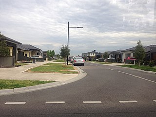
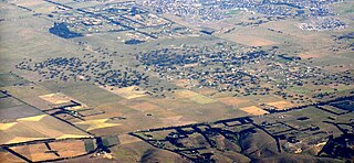
Mickleham is a suburb of Melbourne, Victoria, Australia, 29 km (18 mi) north of Melbourne's central business district, located within the City of Hume local government area and beyond the Urban Growth Boundary. Mickleham recorded a population of 17,452 at the 2021 census, compared to 3,142 at the 2016 census. In 2018, it was covered by the Australian Broadcasting Corporation as Australia's fastest-growing suburb.

Roxburgh Park is a suburb in Melbourne, Victoria, Australia, 21 km (13 mi) north of Melbourne's Central Business District, located within the City of Hume local government area. Roxburgh Park recorded a population of 24,129 at the 2021 census.

Westmeadows is a suburb in Melbourne, Victoria, Australia, 16 km (9.9 mi) north-west of Melbourne's Central Business District, located within the City of Hume local government area. Westmeadows recorded a population of 6,502 at the 2021 census.

Fawkner is a suburb in Melbourne, Victoria, Australia, 12 km (7.5 mi) north of Melbourne's Central Business District, located within the Cities of Hume and Merri-bek local government areas. Fawkner recorded a population of 14,274 at the 2021 census.
Dallas is a suburb in Melbourne, Victoria, Australia, 17 km (11 mi) north of Melbourne's Central Business District, located within the City of Hume local government area. Dallas recorded a population of 6,762 at the 2021 census.

Erinbank Secondary College was a Victorian Government secondary college that closed in 2008. The college was located in Westmeadows a north-western suburb of Melbourne, Australia. Erinbank provided a comprehensive education from years 7 through to 12 offering both VCE and VCAL qualifications at Year 11 and 12 levels.
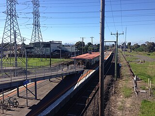
Jacana is a suburb in Melbourne, Victoria, Australia, 14 km (8.7 mi) north of Melbourne's Central Business District, located within the City of Hume local government area. Jacana recorded a population of 2,187 at the 2021 census.
Gladstone Park is a suburb in Melbourne, Victoria, Australia, 15 km (9.3 mi) north-west of Melbourne's Central Business District, located within the City of Hume local government area. Gladstone Park recorded a population of 8,213 at the 2021 census.
Mickleham Road is a secondary road located in Victoria, Australia, north of Melbourne.

Hume Central Secondary College is a co-educational public school located in Broadmeadows, Victoria, Australia. Hume Central was founded in the mid 2000s by the merger of underperforming Erinbank, Broadmeadows and Hillcrest Secondary Colleges.

The Victorian Socialists (VS) are a political party based in the Australian state of Victoria.

Hillcrest Secondary College was a Victorian Government secondary college. The college was located in Broadmeadows a largely working class suburb of Melbourne, Australia. Hillcrest provided a comprehensive education from years 7 through to 12 offering both VCE and VCAL qualifications at Year 11 and 12 levels.

