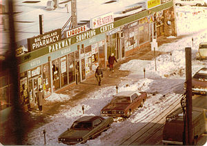
Wakefield is a working-class and middle-class section of the northern borough of the Bronx in New York City. It bounded by the city's border with Westchester County to the north, 222nd Street to the south, and the Bronx River, Bronx River Parkway, and Metro-North Railroad tracks to the west. Wakefield is the northernmost neighborhood in New York City. The neighborhood is part of Bronx Community District 12. The neighborhood's primary ZIP Code is 10466, but certain areas around East 241st Street and White Plains Road are part of 10470.
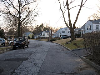
Crestwood is a neighborhood in Yonkers, New York. Located in northeastern Yonkers, Crestwood is separated by the Bronx River from the village of Tuckahoe. Because the majority of Crestwood is served by the Tuckahoe post office, many residents identify their location as Tuckahoe or Crestwood, rather than Yonkers.
Allerton is a working-class neighborhood geographically located in the East Bronx section of the Bronx, New York City. It is named in honor of Daniel Allerton, an early Bronx settler who purchased and farmed this area with his wife Hustace. It consists of both the Bronxwood and Laconia neighborhoods. The neighborhood is part of Bronx Community Board 11. Its boundaries, starting from the north and moving clockwise, are: East Gun Hill Road to the north, IRT Dyre Avenue Line to the east, Waring Avenue south, and Bronx River Parkway to the west. White Plains Road is the primary thoroughfare through Allerton. The local subway is the IRT White Plains Road Line. ZIP codes include 10467. The area is patrolled by the NYPD's 49th Precinct located at 2121 Eastchester Road in the Morris Park section of the Bronx.

Soundview is a working-class neighborhood geographically located in the Clason Point section of the borough of the Bronx in New York City. The neighborhood is part of Bronx Community Board 9. Its boundaries, starting from the North and moving clockwise are the Cross-Bronx Expressway to the North, White Plains Road to the East, Lacombe Avenue to the South, and the Bronx River to the West. The Bruckner Expressway bisects the neighborhood horizontally along the center and the Bronx River Parkway runs north to south. Soundview Avenue is the primary thoroughfare through Soundview.
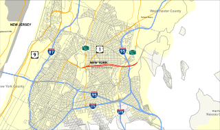
The North Bronx is the northern section of the Bronx, one of the five boroughs of New York city. It is bordered by Westchester County to the North, the South Bronx to the south, the Hudson River to the west and the Atlantic Ocean to the east. The western part is more urbanized and hilly than its eastern counterpart, just like the rest of the borough. Despite being recognized as different from the South Bronx, the actual borders of the North Bronx is undefined. One commonly set border is Fordham Road/Pelham Parkway, the upper limit for widespread poverty and arson during the 1970's and 1980's.
North Riverdale is the northernmost part of the Riverdale neighborhood of the borough of the Bronx in New York City, particularly above 254th Street. It is a residential sub-neighborhood, and shares its northern border with Yonkers, New York in Westchester County.

Bedford Park is a residential neighborhood in the northwest Bronx, New York City, between the New York Botanical Garden and Lehman College. Its boundaries, starting from the north and moving clockwise are: Mosholu Parkway to the north, Webster Avenue to the east, East 196th Street to the south, and the Jerome Reservoir and Goulden Avenue to the west.
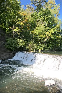
Bronx Park, laid out on 718 acres (2.91 km2) along the Bronx River in the Bronx, New York City, is the home of the New York Botanical Garden and the Bronx Zoo. Bicycle paths go northwest, north, and east, along Mosholu Parkway, Bronx River Parkway, and Pelham Parkway respectively. The east end of Fordham Road is inside the park, at an interchange with the Pelham and Bronx River Parkways, and divides the park roughly in half, with the Botanical Garden occupying most of the north half and the Zoo most of the south. The Bronx River Parkway runs north / south near the eastern edge. The park is operated by the New York City Department of Parks and Recreation. The East Coast Greenway travels through Bronx Park.
The Bronx and Pelham Parkway, also known formally as the Bronx–Pelham Parkway but called Pelham Parkway in everyday use, is a 2.25-mile-long (3.62 km) parkway in the borough of the Bronx in New York City. Despite the parkway moniker, Pelham Parkway is partially limited access and partially a local street, with two main roadways, and two service roads during the local street section. Like other parkways in New York City, commercial traffic is not permitted, and is redirected to the service roads.

Pelham Parkway is a working- and middle-class residential neighborhood geographically located in the center of the Bronx, a borough of New York City in the United States. The neighborhood is part of Bronx Community Board 11. Its boundaries, starting from the north and moving clockwise are: Waring Avenue to the north, the IRT Dyre Avenue Line tracks to the east, Neill Avenue to the South, and Bronx River Parkway to the west. White Plains Road is the primary commercial thoroughfare through Bronx Park East.
Fordham Road is a major throughfare in the Bronx borough of New York City that runs east-west from the Harlem River to Bronx Park. Fordham Road houses the borough's largest and most diverse shopping district. It geographically separates the North Bronx from the South Bronx.
The West Bronx is a region in the New York City borough of the Bronx. The region lies west of the Bronx River and roughly corresponds to the western half of the borough.

The East Bronx is that part of the New York City borough of the Bronx which lies east of the Bronx River; this roughly corresponds to the eastern half of the borough. Neighborhoods include: Harding Park, Soundview, Castle Hill, Parkchester, Westchester Square, Edgewater Park, Van Nest, Pelham Parkway, Morris Park, Throggs Neck, Country Club, City Island, Pelham Bay, Williamsbridge, Eastchester, Baychester, Edenwald, Wakefield, and Co-op City.
Jerome Avenue is one of the longest thoroughfares in the New York City borough of the Bronx, New York, United States. The road is 5.6 miles (9.0 km) long and stretches from Highbridge general area to Woodlawn. Both of these termini are with the Major Deegan Expressway which runs parallel to the west. Most of the elevated IRT Jerome Avenue Line runs along Jerome Avenue. The Cross Bronx Expressway interchanges with Jerome and the Deegan. Though it runs through what is now the West Bronx neighborhood, Jerome Avenue is the dividing avenue between nominal and some named "West" and "East" streets in the Bronx; Fifth Avenue, and to a lesser extent, Broadway, also splits Manhattan into nominal "West" and "East" streets.

White Plains Road is a major north-south thoroughfare which runs the length of the Bronx borough of New York City. It runs from Castle Hill and Clason Point in the south to Wakefield in the north, where it crosses the city line and becomes West 1st Street of Mount Vernon, New York. The Bronx River Parkway lies to its west and parallels much of its route. Between Magenta Street & 217th Street, White Plains Road is very wide due to the presence of the Gun Hill Road station house in the road's median.
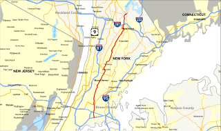
New York State Route 164 (NY 164) was a state highway in the New York City Metropolitan Area. It extended for 5 miles (8 km) from U.S. Route 9 (US 9) and NY 9A in Yonkers to US 1 in the New York City borough of the Bronx. The route ran mostly along the New York City line and indirectly met both the Saw Mill River Parkway and the New York State Thruway in Yonkers. NY 164 followed McLean Avenue in Yonkers and Nereid and Baychester Avenues in the Bronx.

Sedgwick Avenue is a major street in the Bronx, New York City. It runs roughly parallel to Jerome Avenue, the Major Deegan Expressway, and University Avenue. Sedgwick Avenue is one of the longest streets in the western part of the Bronx, running from Mosholu Parkway at the north to Macombs Dam Bridge at its southern end, about 800 feet west of Yankee Stadium.