
Brough Castle is a ruined castle near Brough, Caithness. It is believed to date from the 12th to 14th centuries.
Brough Castle is a ruined castle near Brough, Caithness. It is believed to date from the 12th to 14th centuries.
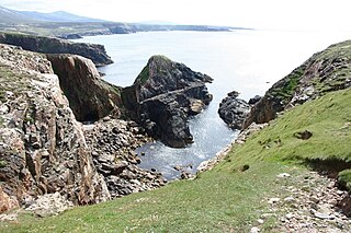
The foundations of the castle are on the landward end of a long rocky promontory about 1⁄4 mile (400 m) north of the east end of the hamlet of Brough. A trench some 40 feet (12 m) wide and 10 to 12 feet (3 to 4 m) deep has been dug across the neck and on either side of the rock; in rear of it has been a range of buildings separated by a narrow courtyard or passage. The keep is not recognisable. The promontory tails away seawards to a shelf of rock. There appears to be no history of this castle. [1]

A broch is an Iron Age drystone hollow-walled structure found in Scotland. Brochs belong to the classification "complex Atlantic roundhouse" devised by Scottish archaeologists in the 1980s. Their origin is a matter of some controversy.

The Castle of Mey is located in Caithness, on the north coast of Scotland, about 6 miles (10 km) west of John o' Groats. In fine weather there are views from the castle north to the Orkney Islands.
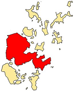
The Mainland, also known as Hrossey and Pomona, is the main island of Orkney, Scotland. Both of Orkney's burghs, Kirkwall and Stromness, lie on the island, which is also the heart of Orkney's ferry and air connections.

Dunbeath Castle is located on the east coast of Caithness, 2 kilometres (1.2 mi) south of Dunbeath, in northern Scotland. Although a castle has stood here since the 15th century, the present building is of mainly 17th-century origin, with 19th-century extensions. The castle is a Category A listed building and the grounds are included in the Inventory of Gardens and Designed Landscapes in Scotland.
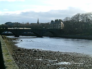
Wick is a town and royal burgh in Caithness, in the far north of Scotland. The town straddles the River Wick and extends along both sides of Wick Bay. "Wick Locality" had a population of 6,954 at the time of the 2011 census, a decrease of 3.8% from 2001.
Dunnet is a village in Caithness, in the Highland area of Scotland. It is within the Parish of Dunnet.

Courthouse and Jail Rocks are two rock formations located near Bridgeport in the Nebraska Panhandle.
Holborn Head is a headland on the north-facing Atlantic coast of Caithness, in the Highland area of Scotland. The point of Holborn Head is at 58°37′23″N03°32′06″W. It has a lighthouse at its south end and the remains of an old fort at its tip.

Candleston Castle is a 14th-century fortified manor house, in ruins since the 19th century. It is .75 miles (1.21 km) southwest of Merthyr Mawr, former Glamorgan, Wales, now Bridgend county borough and just .75 miles (1.21 km) northwest of Ogmore Castle, separated by the River Ogmore. Candleston's original long and narrow rectangular structure lay across the western end of a low narrow promontory, suggesting a defensive position. The castle is believed to be named after the Norman family of Cantilupe, thought to be its first feudal tenants.
The Royal Commission on the Ancient and Historical Monuments of Scotland (RCAHMS) was an executive non-departmental public body of the Scottish Government that was "sponsored" [financed and with oversight] through Historic Scotland, an executive agency of the Scottish Government.

Braal Castle is located by the River Thurso north of the village of Halkirk, in Caithness, northern Scotland. The ruined castle, which dates back to the mid-14th century, was originally known as the Castle of Brathwell.

Roslin Castle is a partially ruined castle near the village of Roslin in Midlothian, Scotland. It is located around 9 miles south of Edinburgh, on the north bank of the North Esk, only a few hundred metres from the famous Rosslyn Chapel.

Clett is a name used for many uninhabited Scottish islets and one to the south, though also in the area inhabited by Vikings. They include -
Ravenscraig Castle is a ruined castle located in Kirkcaldy which dates from around 1460. The castle is an early example of artillery defence in Scotland.
Stac Dhòmnuill Chaim, or Stac Dhòmhnaill Chaim, or Stac Domhnuill Chaim, is a fortified promontory located near Mangursta on the Isle of Lewis in the Outer Hebrides of Scotland. The stack and its surrounding site is listed and protected as a scheduled monument. The site of the stack is located at grid reference NB00223152. The site is named after Donald Cam Macaulay, the early 17th century hero of the Macaulays of Uig. The site was documented in the late 19th century, but today it is considered inaccessible. In 2003 and 2006, an archaeological team of rock climbers scaled the promontory and documented the site; finding in 2006 a piece of possibly Neolithic pottery.
Kirkwall Castle, also known as King's Castle, was located in Kirkwall, the main settlement in the Orkney Islands of Scotland. Built in the 14th century, it was deliberately destroyed in 1614. The last ruins were cleared in the 19th century. The castle was located around the corner of Broad Street and Castle Street in the centre of Kirkwall.

Keiss Castle is a partially ruined castle in Scotland, which stands on sheer cliffs overlooking Sinclair's Bay less than one mile north of Keiss village centre, Caithness, Highland, Scotland. It is protected as a scheduled monument. The old castle was replaced by Keiss House around 1755.

Thurso Castle is a ruined 19th-century castle, located in Thurso, Caithness, in the Scottish Highlands. Situated in Thurso East, off Castletown Road, east of the River Thurso, the site can be seen from across the river. The current castle ruins date to 1872; A large part was demolished in 1952, although there has been a fortress here since the 12th century. Part of the castle is still habitable and remains a home of the Viscounts Thurso.
Broch of Inshlampie is an Iron Age broch in Scotland.
Dounreay Castle is a ruined 16th-century L-plan castle, about 8 miles (13 km) west of Thurso, Highland, Scotland, within the grounds of Dounreay Nuclear Power Development Establishment. It is also known as Dounreay House. The castle and its associated structures are a Scheduled Ancient Monument.
![]() This article incorporates text from this source, which is in the public domain :Third Report and Inventory of Monuments and Constructions in the County of Caithness, 1911
This article incorporates text from this source, which is in the public domain :Third Report and Inventory of Monuments and Constructions in the County of Caithness, 1911