Related Research Articles

Melton is a local government district with borough status in north-eastern Leicestershire, England. It is named after its only town, Melton Mowbray. The borough also includes numerous villages and surrounding rural areas. The north of the district includes part of the Vale of Belvoir. Melton is the least populous district of its type and the fourth least populous district in England overall.

Old Dalby is a village and former civil parish, now in the parish of Broughton and Old Dalby, in the Melton district of Leicestershire, England. It is located to the north-west of Melton Mowbray. It was originally known as "Wold Dalby" or "Dalby on the Wolds". In 1931 the parish had a population of 315. On 1 April 1936 the parish was abolished to form "Broughton and Old Dalby".

Woodhouse, often known to locals as Old Woodhouse, is a small village and civil parish in the heart of Charnwood, England. The population of the civil parish at the 2011 census was 2,319, including around 300 term-time boarders at the Defence College. The parish includes the larger village of Woodhouse Eaves. The parish of Woodhouse was formed in 1844. The village is located between the larger Woodhouse Eaves and Quorn villages, the village contains a mixture of small cottages and large modern houses. It is a commuter village for both Leicester and Loughborough, as well as further afield.

The Vale of Belvoir covers adjacent areas of Leicestershire, Nottinghamshire and Lincolnshire, England. The name derives from the Norman-French for "beautiful view" and dates back to Norman times.

Ab Kettleby is a village and civil parish in the Melton district of Leicestershire, England, located 3 miles (4.8 km) north of Melton Mowbray, on the A606 road. It had a population of 501 in 2001; at the 2011 census this had increased to 529.
Melton and Belvoir Rural District was a rural district of Leicestershire, England, from 1935 to 1974.

Broughton is a village and civil parish in the Huntingdonshire district of Cambridgeshire, England, around six miles north of Huntingdon. Broughton is situated within Huntingdonshire which is a non-metropolitan district of Cambridgeshire as well as being a historic county of England. According to the UK census of 2001 it had a population of 241, reducing to 237 at the 2011 census.

Bulcote is a village and civil parish in the Newark and Sherwood district of Nottinghamshire, England. According to the 2001 census it had a population of 330, reducing to 309 at the 2011 census, and 272 at the 2021 census. The village is on the fringe of the Greater Nottingham area, and is about 7 miles north-east of Nottingham city centre. Nearby places are Burton Joyce and Lowdham.
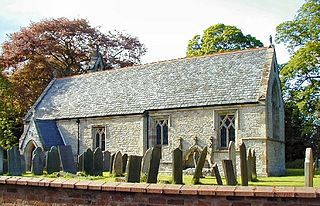
Burton and Dalby is a civil parish in the Melton district of Leicestershire, England, to the south of Melton Mowbray. It covers the villages of Burton Lazars, Great Dalby and Little Dalby and according to the 2001 census had a population of 895, Increasing to 985 at the 2011 census.

Heworth Without is a civil parish and a ward in the City of York district, in the ceremonial county of North Yorkshire, England. Its boundary has changed over time. The ward is not coterminous with Heworth Without parish. While it consists today largely of those parts of Heworth that lay beyond the (pre-1996) city boundary, some areas such as Straylands Grove are within Heworth Without ward, but were also within the old city boundaries.

Elslack is a village and civil parish in the former Craven District of North Yorkshire, England, close to the border with Lancashire and 4.5 miles (7.2 km) west of Skipton. Thornton in Craven is nearby. The Tempest Arms is a large pub in the village, sited by the A56, which is popular with locals from the surrounding area. Elslack Moor, above the village, is crossed by the Pennine Way, though this does not visit the village itself. In 2015 it had a population of 100.
Costock is a village and civil parish in the Rushcliffe district of Nottinghamshire, England. The population of the civil parish was estimated at 664 in 1998, and reported at the 2011 census as 621. There were 645 residents counted at the 2021 census. Although in Nottinghamshire, Costock's closest town is Loughborough in Leicestershire.

The A606 is an A road in England that starts in West Bridgford, on the outskirts of Nottingham, and heads southeastwards through Leicestershire and the towns of Melton Mowbray and Oakham, terminating at Stamford, Lincolnshire on the former Great North Road.

Langwith is a close group of six villages crossing the Derbyshire-Nottinghamshire border, on the River Poulter about 2 miles (3.2 km) from Warsop, and about 4 miles (6.4 km) from Bolsover on the A632 road, south of Whaley Thorns. The population is listed under the Derbyshire civil parish of Langwith and the Nottinghamshire civil parish of Nether Langwith.

Widmerpool was a railway station serving Widmerpool in the English county of Nottinghamshire. It was situated on the Nottingham direct line of the Midland Railway between London and Nottingham via Corby.

Upper Broughton was a railway station serving Upper Broughton in the English county of Nottinghamshire. It was opened on the Nottingham direct line of the Midland Railway between London and Nottingham, avoiding Leicester. The line still exists today as the Old Dalby Test Track.
Nether Broughton is a village and former civil parish, now in the parish of Broughton and Old Dalby, in the Melton district of Leicestershire, England. Broughton and Old Dalby's parish council is based in Nether Broughton. The village lies on the main A606 road between Melton Mowbray and Nottingham. The neighbouring village of Upper Broughton is on the same road, but within Nottinghamshire. In 1931 the parish had a population of 345. On 1 April 1936 the parish was abolished to form "Broughton and Old Dalby".

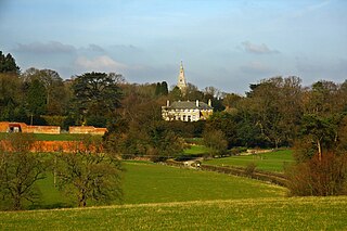
Saxelbye is a small village and former civil parish, now in the parish of Grimston, in the district of Melton in Leicestershire, England. The village lies about three miles to the north-west of Melton Mowbray and is situated on the southern slope of the ridge that makes up the southern boundary of the Vale of Belvoir. In 1931 the parish had a population of 75. On 1 April 1936 the parish of Saxelby was abolished and merged with Grimston.

Upper Broughton or Broughton-Sulney or Over-Broughton is a village and civil parish about seven miles north west of Melton Mowbray, in the Rushcliffe district of the county of Nottinghamshire, England. In 2011 the built-up area had a population of 327, the same as the parish. The parish count increased to 346 at the 2021 census. The parish touches Wymeswold, Hickling, Widmerpool, Broughton and Old Dalby and Willoughby on the Wolds. Upper Broughton is a conservation area that was designated in 1973 and is 16 hectares. The settlement is near the boundary with Leicestershire, and Nether Broughton is across the county boundary.

Stanton-on-the-Wolds is a small village and a civil parish in Nottinghamshire, England. It is situated about 6 miles (10 km) south-east of Nottingham, just off the A606 Nottingham to Melton Mowbray road. It is bordered by several other villages, namely, Clipston-on-the-Wolds, Normanton-on-the-Wolds, Keyworth and Widmerpool. 413 residents within the parish were reported at the 2021 census.
References
- ↑ Ordnance Survey: Landranger map sheet 129 Nottingham & Loughborough (Melton Mowbray) (Map). Ordnance Survey. 2014. ISBN 9780319231623.
- ↑ M. of H. Order No. 84988. The County of Leicester (Melton and Belvoir RD) (Union of Parishes) Confirmation Order, 1936
- ↑ The East Midland Counties Order, 1965
52°49′05″N0°59′17″W / 52.818°N 0.988°W
| | This Leicestershire location article is a stub. You can help Wikipedia by expanding it. |