
The Smith River flows from the Klamath Mountains to the Pacific Ocean in Del Norte County in extreme northwestern California, on the West Coast of the United States. The river, about 25.1 miles (40.4 km) long, all within Del Norte County, flows through the Rogue River – Siskiyou National Forest, Six Rivers National Forest, and Jedediah Smith Redwoods State Park.
A cantilever bridge is a bridge built using structures that project horizontally into space, supported on only one end. For small footbridges, the cantilevers may be simple beams; however, large cantilever bridges designed to handle road or rail traffic use trusses built from structural steel, or box girders built from prestressed concrete.

A truss bridge is a bridge whose load-bearing superstructure is composed of a truss, a structure of connected elements, usually forming triangular units. The connected elements, typically straight, may be stressed from tension, compression, or sometimes both in response to dynamic loads. There are several types of truss bridges, including some with simple designs that were among the first bridges designed in the 19th and early 20th centuries. A truss bridge is economical to construct primarily because it uses materials efficiently.

The Jamestown Bridge was a cantilever truss bridge that connected Conanicut Island to mainland North Kingstown, Rhode Island, spanning the West passage of Narragansett Bay. The bridge first opened to traffic in 1940, replacing ferry service as the primary connection for the town of Jamestown, situated on Conanicut Island. It was constructed for just over $3 million 1940 USD, which was paid for by tolls until June 28, 1969. With a total length of 6,892 feet, the Jamestown Bridge was the third longest in Rhode Island at the time of its destruction, ranking behind its replacement, the adjacent 7,350-foot Jamestown Verrazzano Bridge, and the 11,248-foot Claiborne Pell Newport Bridge connecting Conanicut Island to Aquidneck Island and Newport. The Jamestown Bridge was closed to vehicular traffic on October 8, 1992, and its main span was destroyed through a controlled demolition on April 18, 2006.

The Talmadge Memorial Bridge is a bridge in the United States spanning the Savannah River between downtown Savannah, Georgia, and Hutchinson Island. It carries US 17/SR 404 Spur. The original cantilever bridge was built in 1953; a replacement bridge was completed in 1991, and named the Talmadge Memorial Bridge.

The Brown Covered Bridge is a wooden covered bridge in Shrewsbury, Vermont. Located in the northwestern part of the town, it carries Upper Cold River Road over the Cold River. It was closed to vehicular traffic in 2011 due to damage from Hurricane Irene and reopened on July 5, 2016. Built in 1880 by noted Vermont bridgewright Nichols M. Powers, it was designated a National Historic Landmark in 2014, cited as one of the finest and least-altered examples of a Town lattice truss covered bridge in the United States.
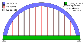
A tied-arch bridge is an arch bridge in which the outward-directed horizontal forces of the arch(es) are borne as tension by a chord tying the arch ends rather than by the ground or the bridge foundations. This strengthened chord may be the deck structure itself or consist of separate, independent tie-rods.

A continuous truss bridge is a truss bridge that extends without hinges or joints across three or more supports. A continuous truss bridge may use less material than a series of simple trusses because a continuous truss distributes live loads across all the spans; in a series of simple trusses, each truss must be capable of supporting the entire load.

The Miami Bridge, also known as the McDaniel Memorial Bridge, is a new concrete girder bridge that was built to replace a cantilever through truss bridge over the Missouri River at Miami, Missouri between Saline County, Missouri and Carroll County, Missouri. The Miami Bridge carries Route 41. The Miami Bridge was built in 1939, and its deck was replaced in 1983 as part of a rehabilitation project. The old bridge's main cantilever span was 474.7 feet, while the two anchor spans were each 415 feet in length, resulting in a total cantilever truss length of 1304.7 feet. There were 11 approach spans, including four Warren deck truss spans, three on the northern approach and one on the southern approach. All remaining approach spans were steel stringer (multi-beam/girder) spans. Total bridge length including approach spans is 2,071.9 feet. The bridge's deck width is 23.0 feet and it has vertical clearance of 16.5 feet.

The Bryan Bridge was constructed to carry U.S. Route 20 over the Niobrara River in Cherry County, Nebraska, near Valentine. It was built in 1932 and is a pin-connected arch bridge that is designated "Most Beautiful Steel Bridge" in its year, out of bridges costing less than $250,000, by the American Institute of Steel Construction. It is named after then-sitting Nebraska governor Charles W. Bryan.

Sadliers Crossing Railway Bridge is a heritage-listed railway bridge at over Bremer River between Tallon Street, Sadliers Crossing and Dixon Street, Wulkuraka, Queensland, Australia on the Main Line (this section is now the Ipswich and Rosewood railway line. It was added to the Queensland Heritage Register on 13 November 2008.

The South Street Bridge is a historic Pratt truss bridge, carrying Vermont Route 31 across the Poultney River just south of the village center of Poultney, Vermont. Built in 1923, it is one of a small number of surviving Pratt through trusses in the state, and one of just three that survives from the period before the state's devastating 1927 floods. It was listed on the National Register of Historic Places in 2009 as Bridge 4.

The Winooski Street Bridge is a historic bridge carrying Winooski Street across the Winooski River between Duxbury and Waterbury, Vermont. Built in 1928, it is a Parker through truss, one of only two of this type on the Winooski River and an increasingly rare bridge type in the state. It was listed on the National Register of Historic Places in 2006 as Bridge 31.

The Straight Street Bridge is a vehicular bridge over the Passaic River in Paterson, New Jersey, that is listed on the National Register of Historic Places.

The Winooski River Bridge, also known locally as the Checkered House Bridge, is a historic Pennsylvania through truss bridge, carrying U.S. Route 2 (US 2) across the Winooski River in Richmond, Vermont. Built in 1929, it is one of only five Pennsylvania trusses in the state, and was the longest bridge built in the state's bridge-building program that followed massive flooding in 1927. The bridge was listed on the National Register of Historic Places in 1990.

The Macquarie River railway bridge is a heritage-listed disused railway bridge across the Macquarie River that was previously located on the Main Western line in Bathurst in the Bathurst Region local government area of New South Wales, Australia. It was built in 1876. It is also known as Bathurst Rail Bridge over Macquarie River and Bathurst – Kelso Railway Bridge. The property is owned by Transport Asset Holding Entity, an agency of the Government of New South Wales. The bridge was added to the New South Wales State Heritage Register on 2 April 1999 and was added to the Register of the National Estate on 18 April 1989.
The Murrumbidgee River bridge, Carrathool is a heritage-listed road bridge that, until its closure in 2019, carried Carrathool Road across the Murrumbidgee River in Carrathool, New South Wales, Australia. The bridge is owned by Transport for NSW. The bridge is also called the Carrathool Bridge over Murrumbidgee River and provides a key connection between the Sturt Highway and the Murrumbidgee Road. It was added to the New South Wales State Heritage Register on 20 June 2000.

The Murrumbidgee River railway bridge is a heritage-listed railway bridge across the Murrumbidgee River located on the Tumut railway line at Gundagai in the Cootamundra-Gundagai Regional Council local government area of New South Wales, Australia. It was built in 1903. It is also known as the Gundagai Rail Bridge over Murrumbidgee River and the Murrumbidgee River Railway Bridge. The property was added to the New South Wales State Heritage Register on 2 April 1999.
The Wollombi Brook bridge is a heritage-listed road bridge that carries Putty Road across the Wollombi Brook at Bulga, New South Wales, Australia. The bridge was designed by Harvey Dare and built in 1912. The bridge is owned by Transport for NSW. The bridge was added to the New South Wales State Heritage Register on 20 June 2000.
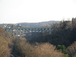
The Charles Anderson Memorial Bridge is a steel deck truss bridge located in Pittsburgh, Pennsylvania, United States. The bridge carries the four-lane roadway of Boulevard of the Allies across a ravine known as Junction Hollow, connecting the neighborhoods of Central Oakland and South Oakland with Schenley Park. The bridge also spans the Junction Hollow Trail and P&W Subdivision railroad tracks which run along the bottom of the valley.
