
Westford is a town in Chittenden County, Vermont, United States. The population was 2,062 at the 2020 census.

Vermont Route 103 is a 42.036-mile-long (67.650 km) north–south state highway in southern Vermont, United States. It runs from U.S. Route 5 in Rockingham in the east to US 7 in Clarendon near Rutland in the west. The Vermont Country Store's second branch is one attraction along the route, as well as the Okemo Ski Resort in Ludlow.

The Brown Covered Bridge is a wooden covered bridge in Shrewsbury, Vermont. Located in the northwestern part of the town, it carries Upper Cold River Road over the Cold River. It was closed to vehicular traffic in 2011 due to damage from Hurricane Irene and reopened on July 5, 2016. Built in 1880 by noted Vermont bridgewright Nichols M. Powers, it was designated a National Historic Landmark in 2014, cited as one of the finest and least-altered examples of a Town lattice truss covered bridge in the United States.

The Bedell Bridge was a Burr truss covered bridge that spanned the Connecticut River between Newbury, Vermont and Haverhill, New Hampshire. Until its most recent destruction in 1979, it was, with a total length of 382 feet (116 m), the second-longest covered bridge in the United States. The bridge was divided into two spans of roughly equal length, and rested on a central pier and shore abutments constructed from mortared rough stone. The eastern abutment has been shored up by the addition of a concrete footing. The bridge was 23 feet (7.0 m) wide, with a roadway width of 18.5 feet (5.6 m). Because the state line is the western low-water mark of the Connecticut River, most of the bridge was in New Hampshire; only the western abutment is in Vermont.

Shushan Bridge is a covered bridge over the Batten Kill in the hamlet of Shushan in Washington County, New York, near Vermont. It is one of 29 surviving historic covered bridges in New York State and one of 4 surviving in Washington County.

Vermont Route 128 (VT 128) is a 11.616-mile-long (18.694 km) north–south state highway in northwestern Vermont, United States. The southern terminus of the route is at VT 15 in Essex, Chittenden County. Its northern terminus is at VT 104 in Fairfax, Franklin County.

The Blair Bridge is a wooden covered bridge built in 1870 that crosses the Pemigewasset River near Campton, New Hampshire, United States. It connects New Hampshire Route 175 to the east and U.S. Route 3 and Interstate 93 to the west.

The East Fairfield Covered Bridge is a covered bridge that carries Bridge Street across Black Creek in the East Fairfield village of Fairfield, Vermont. Built about 1865, it is the town's only surviving 19th century covered bridge. It was listed on the National Register of Historic Places in 1974.
The Holmes Creek Covered Bridge, also called the Lakeshore Covered Bridge, is a one-lane wooden covered bridge that crosses Holmes Creek in Charlotte, Vermont on Lake Road, adjacent to Charlotte Beach. It was listed on the National Register of Historic Places in 1974.

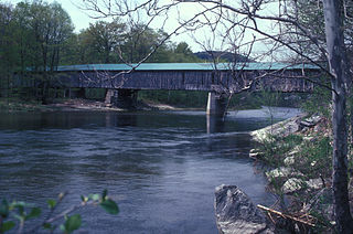
The Great Eddy Covered Bridge, also called the Big Eddy Covered Bridge or Waitsfield Covered Bridge, is a wooden covered bridge that crosses the Mad River in Waitsfield, Vermont on Bridge Street. Built in 1833, it is one of Vermont's oldest covered bridges. It was listed on the National Register of Historic Places in 1974.

The Warren Covered Bridge is a wooden covered bridge that crosses the Mad River in Warren, Vermont on Covered Bridge Road. It was listed on the National Register of Historic Places in 1974.

The Longley Covered Bridge, also known as the Harnois Covered Bridge, is a wooden covered bridge that crosses the Trout River in Montgomery, Vermont on Longley Bridge Road. Built in 1863, this Town lattice truss bridge is the oldest of a group of area bridges built by brothers Sheldon & Savannah Jewett. It was listed on the National Register of Historic Places in 1974. The bridge is closed to traffic, and has been bypassed by an adjacent temporary bridge.

The Dingleton Hill Covered Bridge, also known as the Cornish Mills Bridge, is a historic wooden covered bridge, carrying Root Hill Road over Mill Brook in Cornish Mills, New Hampshire. Built in 1882, it is one of the state's few surviving 19th-century covered bridges. It was listed on the National Register of Historic Places in 1978. It carries one lane of traffic, with a posted weight limit.

The Fisher Covered Railroad Bridge is a covered bridge in Wolcott, Vermont. Built in 1908, it originally carried the St. Johnsbury and Lamoille County Railroad line over the Lamoille River. Now closed, it was the last covered bridge in Vermont to carry railroad traffic, and is a rare surviving example in the state of a double Town lattice truss. It was listed on the National Register of Historic Places in 1974.

The Hall Covered Bridge, located in southern Rockingham, Vermont, carries Hall Bridge Road across the Saxtons River, just north of its junction with Vermont Route 121. It is a Town lattice truss bridge, built in 1982 as a replica of a circa-1867 bridge that was destroyed by an overweight truck in 1980. The bridge was listed on the National Register of Historic Places in 1973.
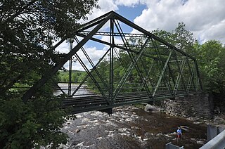
The Medburyville Bridge is a historic bridge in Wilmington, Vermont. It is a steel Warren through bridge, built in 1896 across the Deerfield River, just south of Vermont Route 9 roughly midway between the centers of Wilmington and Searsburg. It stands just upstream of the Woods Road bridge, which functionally replaced it in 1985. The bridge was listed on the National Register of Historic Places in 1990; as it has no decking, it is closed to all forms of traffic.
Scott Covered Bridge is a covered bridge spanning the West River in Townshend, Vermont. Built in 1870, it is at 277 feet (84 m) one of the longest covered bridges in the state, exhibiting three different forms of support: a Town lattice truss, kingpost trusses, and laminated arches. The bridge was listed on the National Register of Historic Places in 1973. It is closed to all traffic.
The Baltimore Covered Bridge is a wooden covered bridge in Springfield, Vermont, United States.
Westford is the primary village and a census-designated place (CDP) in the town of Westford, Chittenden County, Vermont, United States. It was first listed as a CDP prior to the 2020 census.

