The Rio Grande is one of the principal rivers in the southwest United States and northern Mexico. The Rio Grande begins in south-central Colorado in the United States and flows to the Gulf of Mexico. After passing through the length of New Mexico along the way, it forms part of the Mexico–United States border. According to the International Boundary and Water Commission, its total length was 1,896 miles (3,051 km) in the late 1980s, though course shifts occasionally result in length changes. Depending on how it is measured, the Rio Grande is either the fourth- or fifth-longest river system in North America.

Brownsville is a city in Cameron County in the U.S. state of Texas. It is located on the western Gulf Coast in South Texas, adjacent to the border with Matamoros, Mexico. The city covers 81.528 square miles (211.157 km2) and has a population of 182,781 as of 2019. It is the 131st-largest city in the United States and 16th-largest in Texas. It is part of the Brownsville–Matamoros conurbation. The city is known for its year-round subtropical climate, deep-water, seaport and Hispanic culture.

Matamoros, officially known as Heroica Matamoros, is a city in the northeastern Mexican state of Tamaulipas. It is located on the southern bank of the Rio Grande, directly across the border from Brownsville, Texas, in the United States. Matamoros is the second largest city in the state of Tamaulipas. As of 2016, Matamoros had a population of 520,367. In addition, the Matamoros–Brownsville Metropolitan Area has a population of 1,387,985, making it the 4th largest metropolitan area on the Mexico–US border. Matamoros is the 39th largest city in Mexico and anchors the second largest metropolitan area in Tamaulipas.
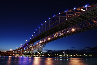
The Blue Water Bridge is a twin-span international bridge across the St. Clair River that links Port Huron, Michigan, United States, and Sarnia, Ontario, Canada. The Blue Water Bridge connects Highway 402 in Ontario with both Interstate 69 (I-69) and Interstate 94 (I-94) in Michigan.
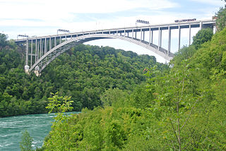
The Lewiston–Queenston Bridge, also known as the Queenston–Lewiston Bridge, is an arch bridge that crosses the Niagara River gorge just south of the Niagara Escarpment. The bridge was officially opened on November 1, 1962. It is an international bridge between the United States and Canada. It connects Interstate 190 in the town of Lewiston, New York to Highway 405 in the community of Queenston, Ontario. The Lewiston–Queenston Bridge is a twin of the Rainbow Bridge at Niagara Falls and designed by Richard Lee.
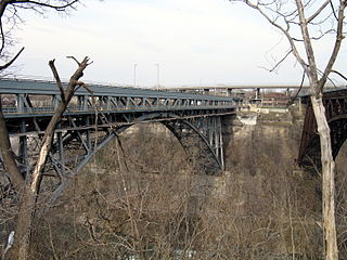
The Whirlpool Rapids Bridge, commonly known as the Whirlpool Bridge or the Lower Steel Arch Bridge, is a spandrel braced, riveted, two-hinged arch bridge. It crosses the international border between Canada and the United States, connecting the commercial downtown districts of Niagara Falls, Ontario and Niagara Falls, New York. This bridge is located approximately 1.5 kilometres (0.9 mi) north of the Rainbow Bridge and about 2 kilometres (1.2 mi) from the Falls. It was acquired by the Niagara Falls Bridge Commission in January 1959. Immediately up stream is the out-of-service Michigan Central Railway Bridge.

The Niagara Falls International Rainbow Bridge, commonly known as the Rainbow Bridge, is an arch bridge across the Niagara River gorge. It connects the cities of Niagara Falls, New York, United States, and Niagara Falls, Ontario, Canada (west).

South Texas is a region of the U.S. state of Texas that lies roughly south of—and including—San Antonio. The southern and western boundary is the Rio Grande, and to the east it is the Gulf of Mexico. The population of this region is about 4.96 million according to the 2017 census estimates. The southern portion of this region is often referred to as the Rio Grande Valley. The eastern portion along the Gulf of Mexico is also referred to as the Coastal Bend.

The Silver Jubilee Bridge crosses the River Mersey and the Manchester Ship Canal at Runcorn Gap between Runcorn and Widnes in Halton, England. It is a through arch bridge with a main arch span of 361 yards. It was opened in 1961 as a replacement for the Widnes-Runcorn Transporter Bridge. In 1975–77 the carriageway was widened, after which the bridge was given its official name in honour of the Queen's Silver Jubilee. It carries the A533 road and a cantilevered footway. The bridge is recorded in the National Heritage List for England as a designated Grade II listed building. The bridge closed for repairs and alterations upon the opening of the new Mersey Gateway Bridge and is due to reopen in 2020.
Gateway Bridge may refer to:
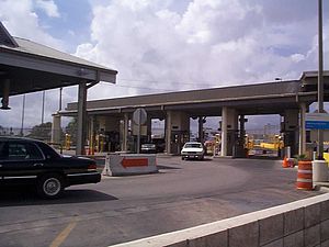
Gateway International Bridge is one of three international bridges that cross the U.S.-Mexico border between the cities of Brownsville, Texas, and Matamoros, Tamaulipas. It is owned and operated by Cameron County. Over the past century, it has developed the nickname of "The New Bridge" when the bridge was remodeled back in the 20th century. Despite the fact that the Veteran's International Bridge is newer than Gateway, it still retains its nickname.

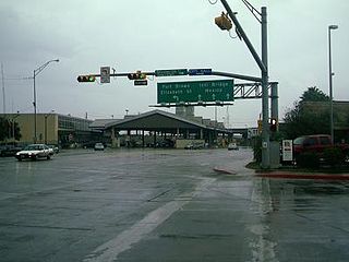
The Brownsville & Matamoros International Bridge, also known as B&M International Bridge, Brownsville-Matamoros International Bridge and Express Bridge, is one of three international bridges that cross the U.S.-Mexico border between the cities of Brownsville, Texas, and Matamoros, Tamaulipas. This international bridge unites the Matamoros–Brownsville Metropolitan Area, which counts with a population of 1,136,995, making it the 4th largest metropolitan area in the Mexico-US border.
The Veterans International Bridge at Los Tomates is one of three international bridges that span the Mexico–United States border between the cities of Brownsville, Texas, and Matamoros, Tamaulipas. It is also known as simply as the Veterans Bridge, the Los Tomates Bridge, or on the Mexico side as the Puente Internacional Ignacio Zaragoza. The bridge is owned and operated by Cameron County.

The Secure Electronic Network for Travelers Rapid Inspection (SENTRI) provides expedited U.S. Customs and Border Protection (CBP) processing, at the U.S.-Mexico border, of pre-approved travelers considered low-risk. Voluntarily applicants must undergo a thorough background check against criminal, customs, immigration, law enforcement, and terrorist databases; a 10-fingerprint law enforcement check; and a personal interview with a CBP Officer. The total enrollment fee is $122.25, and SENTRI status is valid for 5 years.

The Gateway to the Americas International Bridge is one of four vehicular international bridges located in the cities of Laredo, Texas, and Nuevo Laredo, Tamaulipas, that connect the United States and Mexico over the Rio Grande. It is owned and operated by the City of Laredo and the Secretaría de Comunicaciones y Transportes. It is also known as Laredo International Bridge 1.
Federal Highway 180 is a Mexican Federal Highway that follows Mexico's Gulf and Caribbean Coast from the Mexico-U.S. border at Brownsville, Texas, into Matamoros, Tamaulipas, to the resort city of Cancún, Quintana Roo, in the Yucatán Peninsula. Although the highway is numbered as a west-east route, it initially follows a north-south alignment through Tamaulipas and Veracruz.

La Linda International Bridge is an international bridge which crosses the Rio Grande on the United States–Mexico border in the Big Bend region of Texas. The southern terminus of Ranch to Market Road 2627 in Heath Canyon, it connects Brewster County with the village of La Linda in Acuña Municipality, Coahuila.

The Brownsville B&M Port of Entry opened in 1909 with the completion of the Brownsville & Matamoros International Bridge. The bridge was built to carry trains, horses, wagons and pedestrians. The original bridge could swing open to allow river traffic to pass; however it was a function that was almost never used due to the shallowness of the Rio Grande. The bridge was substantially renovated in 1953, and a second 4-lane bridge dedicated to northbound traffic was built adjacent to it in 1997. Since 1999, all truck traffic has been diverted to the Veterans and Los Indios crossings.
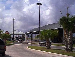
The Brownsville Veterans Port of Entry opened in 1999 with the completion of the Veterans International Bridge at Los Tomates. The bridge was built primarily to divert commercial freight traffic away from the busy downtown bridges, but about a third of the passenger vehicles also cross at this point. The Veterans Port of Entry is the easternmost US-Mexico border crossing, and is by far the newest of the three crossings between Brownsville and Matamoros.