Solna Municipality, is a municipality in central Stockholm County, Sweden, located just north of Stockholm City Centre. Its seat is located in the town of Solna, which is a part of the Stockholm urban area. Solna is one of the richest municipalities in Sweden.

Sundbyberg Municipality is a municipality in Stockholm County in east central Sweden, just north of the capital Stockholm. Sundbyberg is wholly within the Stockholm urban area and has a 100% urban population.

Pirkkala is a municipality in Finland, located in the Pirkanmaa region. It lies to the southwest of the regional capital, Tampere. The population of Pirkkala is approximately 21,000, while the metropolitan area has a population of approximately 423,000. It is the 48th most populous municipality in Finland.

Kungsholmen is an island in Lake Mälaren in Sweden, part of central Stockholm, Sweden. It is situated north of Riddarfjärden and considered part of the historical province Uppland. Its area is 3.9 km2 (1.5 sq mi) with a perimeter of 8.9 km (5.5 mi). The highest point is at Stadshagsplan at 47 metres (154 ft). The total population is 71,542.
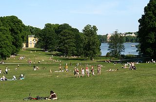
Hagaparken, or simply Haga in Solna Municipality just north of Stockholm, Sweden, is a vast and popular nature area, with large lawns, woods and gardens.

Bergshamra is a suburb within the Stockholm urban area in Sweden. Administratively it is in Solna Municipality of Stockholm County. The suburb is surrounded on three sides by water, with the Stocksundet sea strait to the north-east, the Ålkistan channel to the south-east, and the Brunnsviken to the south-west.

Solna strand is a subway station on the Stockholm metro blue line. It was opened on 18 August 1985 as part of the extension between Västra skogen and Rinkeby and is located in the Huvudsta region of the Solna Municipality. The platform is located in bedrock, 28 m (92 ft) below ground level under Vretenvägen. The entrance is in the north end at Korta gatan. The station's theme is defined by artwork created by the Japanese-Swedish sculptor Takashi Naraha in 1985 called Himmelen av kub.

Solna centrum is a metro station in Solna Municipality, approximately 5 km (3.1 mi) from central Stockholm, Sweden.

Nationalarenan, known as Strawberry Arena since 2024 for sponsorship reasons, is a retractable roof multi-purpose stadium in Stockholm, Sweden. Located next to the lake Råstasjön in Solna, just north of the City Centre, it is the largest stadium in Scandinavia. Since its opening, the venue has served as Sweden's national stadium for men's football, hence the name Nationalarenan.

Stallmästaregården is a historic inn adjacent to the park around the Royal Pavilion at Haga in Solna, just north of the city limits of Stockholm, Sweden. Today, Stallmästaregården is a restaurant with hotel operation.
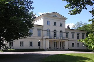
Haga Palace, formerly known as the Queen's Pavilion, is located in the Haga Park, Solna Municipality in Metropolitan Stockholm, Sweden. The palace, built between 1802 – 1805, was modelled after ballet-master Louis Gallodier's Italian villa in Drottningholm by architect Carl Christoffer Gjörwell on appointment by King Gustav IV Adolf for the royal children. It has been the home or summerhouse for several members of the Swedish royal family – most notably it was the birthplace of the present King – until 1966 when King Gustaf VI Adolf transferred its disposal to the government and it was turned into a guesthouse for distinguished foreign official visitors. In 2009, it was announced by Prime Minister Fredrik Reinfeldt that the rights of disposal to the palace would be transferred back to the royal court to be used by Victoria, Crown Princess of Sweden and her husband, Prince Daniel, Duke of Västergötland, as a wedding gift in 2010. They moved into Haga Palace after their wedding on 19 June that year.
Nedre Roasten is a lake in Femundsmarka National Park on the border of Innlandet and Trøndelag counties in Norway. The 2.29-square-kilometre (0.88 sq mi) lake sits on the border of Engerdal Municipality in Innlandet county and Røros Municipality in Trøndelag county. Nedre Roasten is about 50 kilometres (31 mi) southeast of the town of Røros and just under 9 kilometres (5.6 mi) from the border with Sweden. The lake lies about 5 kilometres (3.1 mi) east of the lake Femunden and about 8 kilometres (5.0 mi) west of the lake Rogen which sits along the Swedish border.

Igelbäcken is a small stream in northern Stockholm, Sweden. The drainage area, part of the Royal National City Park and divided into several nature reserves, is shared by the municipalities of Järfälla, Sollentuna, Solna, Stockholm, and Sundbyberg.

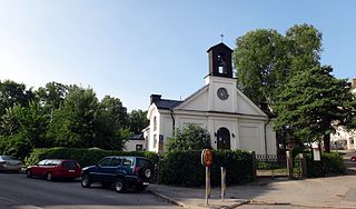
Solna Church is a so-called round church in Solna Municipality near Stockholm, Sweden. It is part of Solna Parish in the Diocese of Stockholm. The church is located on the headland between Brunnsviken and Ulvsundasjön, at the southern end of the cemetery Norra begravningsplatsen. The oldest parts of the church are from the later 12th century, a Romanesque fortress church built in stone.

Edsviken is an elongated, narrow inlet of the Baltic Sea running through the Swedish municipalities of Danderyd, Solna and Sollentuna in Stockholm County. Edsviken ranges from Stocksund and Bergshamra, Solna in the south to Edsberg in the north. The inlet is about 7.7 km (4.8 mi) long with an area of approximately 3.6 km2 (1.4 sq mi); its maximum depth is around 20 m. Edsviken joins the Stocksundet at Bergshamra and eventually flows into the Lilla Värtan.

The SAS Frösundavik Office Building is an office building in Frösundavik, Solna Municipality, Sweden, north of Stockholm. It serves as the head office of Scandinavian Airlines (SAS) and the SAS Group. The SAS head office was for a brief period located in a different building on the property of Stockholm Arlanda Airport in Sigtuna Municipality.
Lilla Alby is a district in the southern corner of Sundbyberg Municipality, Sweden. It lies southwest of the railway Mälaren Line. It is separated from Bromma by bay Bällstaviken to the southwest, and borders Solna Municipality to the south and east, and Centrala Sundbyberg to the north. Lilla Alby has 4,235 citizens.

The Larder River is a river in Timiskaming District, in Northeastern Ontario, Canada. It is in the Saint Lawrence River drainage basin, and flows from its source at Larder Lake in geographic McFadden Township to its mouth as a left tributary of the Blanche River in the municipal township of Evanturel.

The Stegeholm is a Swedish sightseeing motor launch that was built in 1950 as the Queen Mary, and has also been known as the Stella-Fors, Forsman 9, Bellman 4 and Wasaholm 2. Given her current name in 1988, she now operates sightseeing trips for the Strömma Kanalbolaget. Built in mahogany, she is one of the last open wooden sightseeing boats operating in Stockholm, and is a listed historic ship of Sweden.

