Pokrzywnik is a village in the administrative district of Gmina Lubomierz, within Lwówek Śląski County, Lower Silesian Voivodeship, in south-western Poland. Prior to 1945 it was in Germany. It lies approximately 10 kilometres (6 mi) south-east of Lubomierz, 18 km (11 mi) south of Lwówek Śląski, and 100 km (62 mi) west of the regional capital Wrocław.
Siekluki is a village in the administrative district of Gmina Boćki, within Bielsk County, Podlaskie Voivodeship, in north-eastern Poland. It lies approximately 5 kilometres (3 mi) west of Boćki, 22 km (14 mi) south-west of Bielsk Podlaski, and 56 km (35 mi) south of the regional capital Białystok.
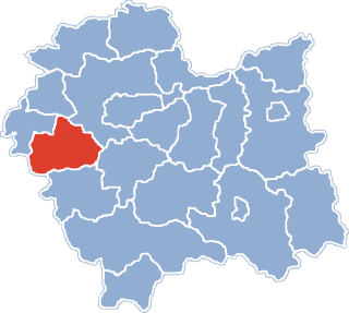
Bagno is a village in the administrative district of Gmina Zwierzyniec, within Zamość County, Lublin Voivodeship, in eastern Poland. It lies approximately 2 kilometres (1 mi) north of Zwierzyniec, 23 km (14 mi) south-west of Zamość, and 74 km (46 mi) south of the regional capital Lublin.
Jaroszowice is a village in the administrative district of Gmina Wadowice, within Wadowice County, Lesser Poland Voivodeship, in southern Poland. It lies approximately 4 kilometres (2 mi) south-east of Wadowice and 37 km (23 mi) south-west of the regional capital Kraków.
Brzezinka is a village in the administrative district of Gmina Brzeźnica, within Wadowice County, Lesser Poland Voivodeship, in southern Poland. It lies approximately 13 kilometres (8 mi) north-east of Wadowice and 26 km (16 mi) south-west of the regional capital Kraków.
Chrząstowice is a village in the administrative district of Gmina Brzeźnica, within Wadowice County, Lesser Poland Voivodeship, in southern Poland. It lies approximately 3 kilometres (2 mi) west of Brzeźnica, 12 km (7 mi) north-east of Wadowice, and 27 km (17 mi) south-west of the regional capital Kraków.
Kopytówka is a village in the administrative district of Gmina Brzeźnica, within Wadowice County, Lesser Poland Voivodeship, in southern Poland. It lies approximately 4 kilometres (2 mi) south of Brzeźnica, 12 km (7 mi) north-east of Wadowice, and 27 km (17 mi) south-west of the regional capital Kraków.
Kossowa is a village in the administrative district of Gmina Brzeźnica, within Wadowice County, Lesser Poland Voivodeship, in southern Poland. It lies approximately 11 kilometres (7 mi) north-east of Wadowice and 28 km (17 mi) south-west of the regional capital Kraków.
Łączany is a village in the administrative district of Gmina Brzeźnica, within Wadowice County, Lesser Poland Voivodeship, in southern Poland. It lies approximately 6 kilometres (4 mi) west of Brzeźnica, 13 km (8 mi) north-east of Wadowice, and 28 km (17 mi) west of the regional capital Kraków.
Marcyporęba is a village in the administrative district of Gmina Brzeźnica, within Wadowice County, Lesser Poland Voivodeship, in southern Poland. It lies approximately 3 kilometres (2 mi) south-west of Brzeźnica, 12 km (7 mi) north-east of Wadowice, and 27 km (17 mi) south-west of the regional capital Kraków.
Nowe Dwory is a village in the administrative district of Gmina Brzeźnica, within Wadowice County, Lesser Poland Voivodeship, in southern Poland. It lies approximately 11 kilometres (7 mi) north-east of Wadowice and 28 km (17 mi) south-west of the regional capital Kraków.
Paszkówka is a village in the administrative district of Gmina Brzeźnica, within Wadowice County, Lesser Poland Voivodeship, in southern Poland. It lies approximately 16 kilometres (10 mi) north-east of Wadowice and 23 km (14 mi) south-west of the regional capital Kraków.
Sosnowice is a village in the administrative district of Gmina Brzeźnica, within Wadowice County, Lesser Poland Voivodeship, in southern Poland. It lies approximately 7 kilometres (4 mi) east of Brzeźnica, 18 km (11 mi) north-east of Wadowice, and 21 km (13 mi) south-west of the regional capital Kraków.
Tłuczań is a village in the administrative district of Gmina Brzeźnica, within Wadowice County, Lesser Poland Voivodeship, in southern Poland. It lies approximately 10 kilometres (6 mi) north-east of Wadowice and 29 km (18 mi) south-west of the regional capital Kraków.
Wyźrał is a village in the administrative district of Gmina Brzeźnica, within Wadowice County, Lesser Poland Voivodeship, in southern Poland. It lies approximately 23 kilometres (14 mi) north-east of Wadowice and 16 km (10 mi) west of the regional capital Kraków.
Półwieś is a village in the administrative district of Gmina Spytkowice, within Wadowice County, Lesser Poland Voivodeship, southern Poland. It lies approximately 11 kilometres (7 mi) north-east of Wadowice and 29 km (18 mi) west of the regional capital Kraków, on the national road No. 44 Kraków - Gliwice. The village has a population of 525.
Grzegorzewice is a village in the administrative district of Gmina Żabia Wola, within Grodzisk Mazowiecki County, Masovian Voivodeship, in east-central Poland. It lies approximately 9 kilometres (6 mi) south-west of Żabia Wola, 16 km (10 mi) south of Grodzisk Mazowiecki, and 38 km (24 mi) south-west of Warsaw.
Domosław is a village in the administrative district of Gmina Winnica, within Pułtusk County, Masovian Voivodeship, in east-central Poland. It lies approximately 3 kilometres (2 mi) south-east of Winnica, 11 km (7 mi) south-west of Pułtusk, and 47 km (29 mi) north of Warsaw.
Niemarzyn is a village in the administrative district of Gmina Miejska Górka, within Rawicz County, Greater Poland Voivodeship, in west-central Poland. It lies approximately 3 kilometres (2 mi) south of Miejska Górka, 9 km (6 mi) east of Rawicz, and 86 km (53 mi) south of the regional capital Poznań.
Książkowice is a village in the administrative district of Gmina Lubsza, within Brzeg County, Opole Voivodeship, in south-western Poland. It lies approximately 10 kilometres (6 mi) north-east of Lubsza, 16 km (10 mi) north-east of Brzeg, and 40 km (25 mi) north-west of the regional capital Opole.