The Struve Geodetic Arc is a chain of survey triangulations stretching from Hammerfest in Norway to the Black Sea, through ten countries and over 2,820 km, which yielded the first accurate measurement of a meridian.

Mill Gate is an old entrance to the city of Stargard, in Poland, which functioned also as a watergate on Ina river. In medieval times the watch lowered a portcullis into the river for the night, which secured Stargard harbour, situated behind the fortification, from intruders. Both towers have the so-called Stargard blend motive. Today the Mill Gate is the seat of Stargard's Society of Fine Art Lovers.
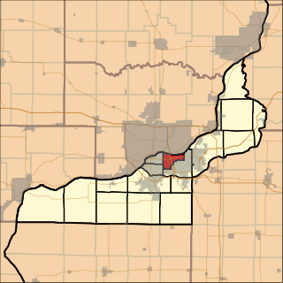
Moline Township is located in Rock Island County, Illinois, USA. At the 2010 census, its population was 23,529 and it contained 10,314 housing units.

Ditak is a village in the Ararat Province of Armenia.
Jrahovit is a town in the Ararat Province of Armenia.

Grupa-Osiedle is a village in the administrative district of Gmina Dragacz, within Świecie County, Kuyavian-Pomeranian Voivodeship, in north-central Poland. It lies approximately 6 kilometres (4 mi) west of Dragacz, 17 km (11 mi) north-east of Świecie, 53 km (33 mi) north of Toruń, and 61 km (38 mi) north-east of Bydgoszcz.
Falków is a village in the administrative district of Gmina Rachanie, within Tomaszów Lubelski County, Lublin Voivodeship, in eastern Poland.
Borówki is a village in the administrative district of Gmina Szamocin, within Chodzież County, Greater Poland Voivodeship, in west-central Poland. It lies approximately 4 kilometres (2 mi) north-east of Szamocin, 20 km (12 mi) east of Chodzież, and 74 km (46 mi) north of the regional capital Poznań.
Łany Średnie is a village in the administrative district of Gmina Żarnowiec, within Zawiercie County, Silesian Voivodeship, in southern Poland. It lies approximately 34 kilometres (21 mi) east of Zawiercie and 70 km (43 mi) north-east of the regional capital Katowice.
Cięgardło is a settlement in the administrative district of Gmina Stara Kiszewa, within Kościerzyna County, Pomeranian Voivodeship, in northern Poland. It lies approximately 9 kilometres (6 mi) west of Stara Kiszewa, 15 km (9 mi) south of Kościerzyna, and 57 km (35 mi) south-west of the regional capital Gdańsk.

Nowaczyzna (, is a village in the administrative district of Gmina Łukta, within Ostróda County, Warmian-Masurian Voivodeship, in northern Poland. It lies approximately 6 kilometres north-west of Łukta, 18 km north of Ostróda, and 31 km west of the regional capital Olsztyn.
Przeczno is a village in the administrative district of Gmina Bierzwnik, within Choszczno County, West Pomeranian Voivodeship, in north-western Poland. It lies approximately 4 kilometres (2 mi) north-east of Bierzwnik, 25 km (16 mi) south-east of Choszczno, and 86 km (53 mi) south-east of the regional capital Szczecin.
Lubczyna is a village in the administrative district of Gmina Goleniów, within Goleniów County, West Pomeranian Voivodeship, in north-western Poland. It lies approximately 9 kilometres (6 mi) south-west of Goleniów and 13 km (8 mi) north-east of the regional capital Szczecin.
Kania, formerly German Kannenberg, is a village in the administrative district of Gmina Chociwel, within Stargard County, West Pomeranian Voivodeship, in north-western Poland. It lies approximately 8 kilometres (5 mi) north-west of Chociwel, 24 km (15 mi) north-east of Stargard, and 45 km (28 mi) east of the regional capital Szczecin.
Svojšice is a village and municipality in Příbram District in the Central Bohemian Region of the Czech Republic.
Huashan is a district of the city of Ma'anshan, Anhui Province, China.

Gunjetina is a village in the municipality of Vlasotince, Serbia. According to the 2002 census, the village has a population of 97 people.
Lutsu is a village in Põlva Parish, Põlva County in southeastern Estonia.
Barelić is a village in the municipality of Vranje, Serbia. According to the 2002 census, the village has a population of 161 people.
Třebonice was founded in the thirteenth century, and became part of Prague in 1968. It is now part of the Prague 5 administrative district, and the local government districts of Prague 13 and Prague 17. Třebonice is part of Zličín and Řeporyje.