Agou is a prefecture in the Plateaux Region of Togo. The seat town is Agou-Gadjepe.
Batnorov is a sum (district) of Khentii Province in eastern Mongolia. Berkh town is 35 km SW from Batnorov sum center.

Highway 46 is a short highway in central Israel. The road, just 4 km long, was created in order to bypass the portion of Highway 40 that crosses the aviation industrial zone near Ben Gurion International Airport, a section of road that suffers from heavy traffic.
Singeyer Pass is a mountain pass on southern Baffin Island, Nunavut, Canada.

Gródek is a village in the administrative district of Gmina Drzycim, within Świecie County, Kuyavian-Pomeranian Voivodeship, in north-central Poland. It lies approximately 4 kilometres (2 mi) south-east of Drzycim, 11 km (7 mi) north-west of Świecie, 49 km (30 mi) north-east of Bydgoszcz, and 55 km (34 mi) north of Toruń.
Nowe Dolistowo is a village in the administrative district of Gmina Jaświły, within Mońki County, Podlaskie Voivodeship, in north-eastern Poland.
Zaścianki is a village in the administrative district of Gmina Sokółka, within Sokółka County, Podlaskie Voivodeship, in north-eastern Poland, close to the border with Belarus.
Podtrzcianka is a settlement in the administrative district of Gmina Janów, within Sokółka County, Podlaskie Voivodeship, in north-eastern Poland.
Kniaziówka is a village in the administrative district of Gmina Sidra, within Sokółka County, Podlaskie Voivodeship, in north-eastern Poland.

Aşağı Qaragüvəndli is a village in the Imishli Rayon of Azerbaijan.
Deşdahat is a village in the Qubadli Rayon of Azerbaijan. Deşdahat is the Azeri and Kurdish village in Qubadli
Valilar is a village in the Yevlakh Rayon of Azerbaijan.

Chlebowo is a village in the administrative district of Gmina Wierzbinek, within Konin County, Greater Poland Voivodeship, in west-central Poland. It lies approximately 2 kilometres (1 mi) south-west of Wierzbinek, 28 km (17 mi) north-east of Konin, and 108 km (67 mi) east of the regional capital Poznań.
Gartki is a village in the administrative district of Gmina Czersk, within Chojnice County, Pomeranian Voivodeship, in northern Poland.
Lipiec is a village in the administrative district of Gmina Stary Dzierzgoń, within Sztum County, Pomeranian Voivodeship, in northern Poland. It lies approximately 9 kilometres (6 mi) north of Stary Dzierzgoń, 26 km (16 mi) east of Sztum, and 73 km (45 mi) south-east of the regional capital Gdańsk.
Podwiejki is a settlement in the administrative district of Gmina Stary Dzierzgoń, within Sztum County, Pomeranian Voivodeship, in northern Poland. It lies approximately 12 kilometres (7 mi) north-east of Stary Dzierzgoń, 33 km (21 mi) east of Sztum, and 77 km (48 mi) south-east of the regional capital Gdańsk.
Jicheon Station is a railway station on the Gyeongbu Line.
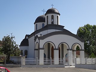
Beli Potok is a village in the municipality of Leskovac, Serbia. According to the 2002 census, the village has a population of 629 people.
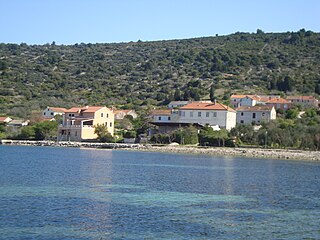
Zaglav is a port village in Croatia. It is connected by the D125 highway and by ferry.
Oud-Mathenesse is a neighborhood of Rotterdam, Netherlands.