Buca Bay

Last updated

Buca Bay is an isolated area on the Fijian island of Vanua Levu. The four villages within this bay are Vunikura, Loa, Buca and Tukavesi. It serves as a terminus for ferries that cross between Vanua Levu and Taveuni.

Fiji country in Oceania

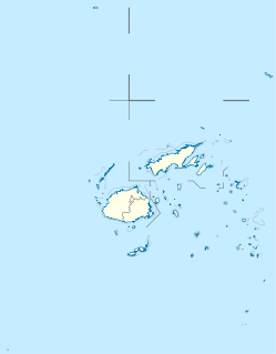
Fiji, officially the Republic of Fiji, is an island country in Melanesia, part of Oceania in the South Pacific Ocean about 1,100 nautical miles northeast of New Zealand's North Island. Its closest neighbours are Vanuatu to the west, New Caledonia to the southwest, New Zealand's Kermadec Islands to the southeast, Tonga to the east, the Samoas and France's Wallis and Futuna to the northeast, and Tuvalu to the north. Fiji consists of an archipelago of more than 330 islands—of which 110 are permanently inhabited—and more than 500 islets, amounting to a total land area of about 18,300 square kilometres (7,100 sq mi). The most outlying island is Ono-i-Lau. The two major islands, Viti Levu and Vanua Levu, account for 87% of the total population of 898,760. The capital, Suva, on Viti Levu, serves as the country's principal cruise-ship port. About three-quarters of Fijians live on Viti Levu's coasts, either in Suva or in smaller urban centres such as Nadi—where tourism is the major local industry—or Lautoka, where the sugar-cane industry is paramount. Due to its terrain, the interior of Viti Levu is sparsely inhabited.

Vanua Levu second largest island in Fiji

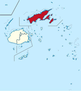
Vanua Levu, formerly known as Sandalwood Island, is the second largest island of Fiji. Located 64 kilometres to the north of the larger Viti Levu, the island has an area of 5,587.1 square kilometres (2,157.2 sq mi) and a population of 135,961 as of 2007.

Taveuni island in Fiji

Taveuni is the third-largest island in Fiji, after Viti Levu and Vanua Levu, with a total land area of 434 square kilometres. The cigar-shaped island, a massive shield volcano which rises from the floor of the Pacific Ocean, is situated 6.5 kilometres to the east of Vanua Levu, across the Somosomo Strait. It belongs to the Vanua Levu Group of islands and is part of Fiji's Cakaudrove Province within the Northern Division.

Electricity is an uncertain factor in Buca Bay, with different villages opting for different source of power including village generator, individual private generator, solar power and Hydro.

Hydroelectricity electricity generated by hydropower

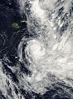
Hydroelectricity is electricity produced from hydropower. In 2015, hydropower generated 16.6% of the world's total electricity and 70% of all renewable electricity, and was expected to increase about 3.1% each year for the next 25 years.

Most inhabitants are small farmers, or try to make a living working in other cities or villages in Vanua Levu. Buca Bay is accessible by bus from Savusavu, about 65 kilometres (40 mi) away via the Hibiscus Highway. Upgrading of the rural road was announced in 2011. [1]

Savusavu town in Fiji

Savusavu is a town in the Fijian Province of Cakaudrove. The town is located on the south coast of Vanua Levu Island and had a population of 3,372 in the 2007 census.

Opposite the bay is the island of Kioa, inhabited by Tuvaluans relocated due to overcrowding and lack of adequate food supplies on their home island. The island of Rabi is also visible from Buca Bay.

Kioa Island in Vanua Levu Group, Fiji

Kioa is an island in Fiji, an outlier to Vanua Levu, one of Fiji's two main islands. Situated opposite Buca Bay, Kioa was purchased by settlers from Vaitupu atoll in Tuvalu, who came between 1947 and 1983.

Tuvalu country in Oceania

Tuvalu, formerly known as the Ellice Islands, is a Polynesian island country located in the Pacific Ocean, situated in Oceania, about midway between Hawaii and Australia. It lies east-northeast of the Santa Cruz Islands, southeast of Nauru, south of Kiribati, west of Tokelau, northwest of Samoa and Wallis and Futuna and north of Fiji. It comprises three reef islands and six true atolls spread out between the latitude of 5° to 10° south and longitude of 176° to 180°, west of the International Date Line. Tuvalu has a population of 10,640. The total land area of the islands of Tuvalu is 26 square kilometres (10 sq mi).

Rabi Island island

Rabi is a volcanic island in northern Fiji. It is an outlier to Taveuni, in the Vanua Levu Group. It covers an area of 66.3 square kilometers, reaching a maximum altitude of 463 meters and has a shoreline of 46.2 kilometers. With a population of around 5,000, Rabi is home to the Banabans who are the indigenous landowners of Banaba Island; the indigenous Fijian community that formerly lived on Rabi was moved to Taveuni after the island was purchased by the Banabans. The original inhabitants still maintain their links to the island, and still use the Rabi name in national competitions.

Natuvu is the site of a new clinic (The Mission at Natuvu Creek), specializing in eye, dental and non-invasive medical treatment. The clinic was scheduled to be operational in February 2008 with water and fuel service at the jetty for yachts and boats. Permanent moorings for short term stays were also planned.

Related Research Articles

Geography of Fiji

Fiji is a group of volcanic islands in the South Pacific, lying about 4,450 kilometres (2,765 mi) southwest of Honolulu and 1,770 km (1,100 mi) north of New Zealand. Of the 332 islands and 522 smaller islets making up the archipelago, about 106 are permanently inhabited. Viti Levu, the largest island, covers about 57% of the nation's land area, hosts the two official cities and most other major towns, such as Nausori, Vaileka, Ba, Tavua, Kororvou, Nasinu, and Nadi, and contains some 69% of the population. Vanua Levu, 64 km (40 mi) to the north of Viti Levu, covers just over 30% of the land area though is home to only some 15% of the population. Its main towns are Labasa and Savusavu. In the northeast it features Natewa Bay, carving out the Loa peninsula.

Labasa town in Fiji

Labasa is a town in Fiji with a population of 27,949 at the most recent census held in 2007.

Northern Division, Fiji division of Fiji

The Northern Division is one of four Divisions into which Fiji's fourteen Provinces are grouped for local government purposes. The administrative centre of the Division, where main governmental departments are located, is Labasa.

Namena Lala is a volcanic islet in Fiji, an outlier to the northern island of Vanua Levu, 24 kilometres (15 mi) away. Situated at 17.11° South and 179.10° East, it covers an area of 4 square kilometres. Its maximum altitude is 105 metres (340 ft). The island is the site of the 0.44 square kilometres Moody's Namenalala Island resort and nature reserve.

The Ringgold Isles are an archipelago in Fiji, forming an outlier group to Vanua Levu. The Budd, Nukusemanu, and Heemskercq Reefs form part of the group. The group is mostly uninhabited, but Qelelevu has a small village. In 2008 Pacific Rats were eradicated from seven islands of the group in an endeavour facilitated by BirdLife International's Fiji Programme.

Qelelevu Island in Ringgold Isles, Fiji

Qelelevu is a coral islet in Fiji, a member of the Ringgold Isles archipelago, which forms an outlier to the northern island of Vanua Levu. Apart from two nearby coral islets, Tai Ni Beka and Tauraria due west on the same atoll rim, it is 30 kilometres (19 mi) from the nearest island, which is Vetauua, to the West. Qelelevu covers an area of 1.5 square kilometers. Its maximum elevation is 12 metres (39 ft).

Taininbeka is an atoll in Fiji, a member of the Ringgold Isles archipelago, which forms an outlier group to the northern island of Vanua Levu. This uninhabited islet is situated at 16.04° South and 179.09° East, and has a total land area of 144.34ha.

Cakaudrove is one of fourteen provinces of Fiji, and one of three based principally on the northern island of Vanua Levu, occupying the south-eastern third of the island and including the nearby islands of Taveuni, Rabi, Kioa, and numerous other islands in the Vanua Levu Group. It has a total land area of 2,816 square kilometers, with a population of 50,469 at the most recent census in 2017, making it the seventh most populous province. The only major town is Savusavu, with a population of 3,372 in 2007.

Macuata is one of Fiji's fourteen Provinces, and one of three based principally on the northern island of Vanua Levu, occupying the north-eastern 40 percent of the island. It has a land area of 2004 square kilometers.

Subrail Park is a stadium in Labasa on the island of Vanua Levu in Fiji. The stadium owned and managed by Labasa Town Council. The stadium has a capacity of 10,000 people at any event. It is the home for Labasa FC and Dreketi. It also hosts rugby union matches, such as the Colonial Cup and the Digicel Cup.

Rail transport in Fiji moves cut sugar cane to crushing mills. Also, there used to be two horse-drawn street tramway systems, some other passenger systems, an underground mine system, and some tramways on construction projects. There are multiple other modes of transport in Fiji.

Mount Nasorolevu is the highest mountain on the island of Vanua Levu in Fiji. Its height is 3,385 feet or 1,032 meters, making it the fourth highest peak of Fiji, Elevation: 3386. It is located at Latitude: -16.6167 and Longitude: 179.4.

Vorovoro is an island in the province of Macuata in the Vanua Levu Group of northern Fiji, 40 minutes away from the town of Labasa by boat.

Cyclone Cliff Category 2 South Pacific cyclone in 2007

Tropical Cyclone Cliff was first noted as a weak tropical disturbance on April 1, 2007, within a trough of low pressure about 210 km (130 mi) to the southwest of Rotuma. Over the next couple of days the system drifted towards the southeast and Fiji, in an area of strong wind shear. During April 3, the system slightly accelerated, as it moved towards the south-southeast before the westerly wind shear around the system relaxed sufficiently to allow the depression to consolidate while it was located near Vanua Levu.

Buca River is a river of Vanua Levu, Fiji.

Labasa River is a river of Vanua Levu, Fiji.

Labasa Mill Tramway

The Labasa Mill Tramway was a 26-mile-long (42 km) narrow gauge railway with a gauge of 2 feet (610 mm) in the northeast of Vanua Levu, the second largest island of Fiji.

References

Coordinates: 16°39′36″S179°51′25″E / 16.660°S 179.857°E / -16.660; 179.857

Geographic coordinate system Coordinate system

A geographic coordinate system is a coordinate system that enables every location on Earth to be specified by a set of numbers, letters or symbols. The coordinates are often chosen such that one of the numbers represents a vertical position and two or three of the numbers represent a horizontal position; alternatively, a geographic position may be expressed in a combined three-dimensional Cartesian vector. A common choice of coordinates is latitude, longitude and elevation. To specify a location on a plane requires a map projection.