
Allamakee County is the northeastern-most county in the U.S. state of Iowa. As of the 2010 census, the population was 14,330. Its county seat is Waukon.
The Maquoketa River is a tributary of the Mississippi River, approximately 150 miles (240 km) long, in northeastern Iowa in the United States. Its watershed covers 1,694 square miles (4,387 km2) within a rural region of rolling hills and farmland southwest of Dubuque. It is not to be confused with the Little Maquoketa River, another distinct direct tributary of the Upper Mississippi River meeting the Big River north of Dubuque. The river and its tributaries mark the border of the Driftless Area of Iowa, with the areas east of it not having been covered by ice during the last ice age. Its name derives from Maquaw-Autaw, which means "Bear River" in Meskwaki.

Caesar Creek State Park is located in southwestern Ohio, five miles (8 km) east of Waynesville, in Warren, Clinton, and Greene counties. The park is leased by the State from the U.S. Army Corps of Engineers, who in the 1970s erected a dam on Caesar Creek to impound a 2,830-acre (1,150 ha) lake. The total park area, including the lake, is 7,941-acre (3,214 ha). The park has 43 miles (69 km) of hiking trails and 31 miles (50 km) of bridle trails.

Allatoona is an unincorporated community in Bartow County, in the U.S. state of Georgia. The community is located along Allatoona Creek, 6 miles (9.7 km) southeast of Cartersville. It was once a small mining community until a dam was erected at the base of the Etowah river, completely flooding the town of Allatoona.

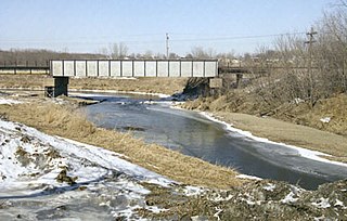
Paint Creek is a direct tributary of the Upper Mississippi River, rising in central Allamakee County, Iowa, in and about the city of Waukon. The catchment measures approximately 85.5 square miles (221 km2). It has some still-rural stretches past 9th Street Southwest in Waukon, but most of the actual Waukon portions have been culverted. It joins the Mississippi approximately 6 miles (9.7 km) above Marquette, Iowa in Pool 10, near river mile 641.

Wilson Lake is a reservoir in the U.S. state of Kansas, on the border of Russell County and Lincoln County. Built and managed by the U.S. Army Corps of Engineers for flood control, it is also used for wildlife management and recreation. Several parks are located along its shoreline, including Wilson State Park.

Perry Lake is a US Army Corps of Engineers operated reservoir in northeast Kansas. Its primary purposes are flood control, water reserve for nearby areas and regional recreation. The lake is approximately 11,150 acres (45 km²) in size, with over 160 miles (260 km) of shoreline. Perry Lake's full multi-purpose pool elevation is 891.5 feet (271.7 m) above sea level. Perry Lake is located about 40 miles (64 km) west of Kansas City, just northwest of Lawrence, Kansas. Its close proximity to Kansas City, Lawrence, and the state capitol, Topeka, make it a very popular destination, with the nickname "Paradise on the Plains".

El Dorado Lake is a reservoir on the Walnut River 0.5 miles (0.80 km) northeast of El Dorado in the Flint Hills region of Kansas. Built and managed by the U.S. Army Corps of Engineers, it is used for flood control, recreation, and water supply. El Dorado State Park is located on its shore.

Sny Magill Creek is a minor tributary of the Upper Mississippi River, rising in central Clayton County, Iowa and flowing to the Upper Mississippi River approximately 2 miles north of Clayton, Iowa. It has a drainage of 22,780 acres (92.2 km2). It is regarded as one of the best trout streams in Iowa. The majority of this forested basin is incorporated into the Sny Magill-North Cedar Creek Wildlife Management Area.
Bluebell Creek is a very minor tributary of the Upper Mississippi River, confined mainly to Millville Township in Clayton County, Iowa, but rising in Liberty Township in Dubuque County. It enters the Mississippi just south of where the Turkey River meets the Big River.

Lake Red Rock, also referred to as Red Rock Reservoir is a reservoir formed by Red Rock Dam on the Des Moines River, about 41 miles southeast of the city of Des Moines, Iowa, U.S.. The dam was completed in 1969 as a Flood control project by the United States Army Corps of Engineers, creating the largest lake in Iowa. The lake is essentially confined to Marion County. The damface is a few miles west and south of Pella, and similarly, a few miles northeast of Knoxville.

Lost Creek Lake is a reservoir located on the Rogue River in Jackson County, Oregon, United States. The lake is impounded by William L. Jess Dam which was constructed by the U.S. Army Corps of Engineers in 1977 for flood control and fisheries enhancement. The lake and dam were the first completed elements of the multi-purpose Rogue River Basin Project, consisting of Lost Creek Lake, Applegate Lake and the Elk Creek project. The lake is located approximately 27 miles (43 km) northeast of Medford.
Roberts Creek State Preserve is located in rural Clayton County, Iowa, in Wagner Township, near St. Olaf, Iowa, and a few miles north of Elkader, Iowa. Roberts Creek is a tributary of the Turkey River.
Buck Creek State Park is a 4,016-acre (1,625 ha) Ohio state park in Clark County, Ohio in the United States, around part of Buck Creek. The park is leased by the state of Ohio from the U.S. Army Corps of Engineers. It includes C. J. Brown Reservoir and Dam, a flood control dam and reservoir built by the USACE as part of a flood control system in the Ohio River drainage basin. Buck Creek State Park is open for year-round recreation including camping, boating, hunting, fishing, swimming, picnicking and hiking.

Fairfield Township is one of twenty townships in Fayette County, Iowa, USA. As of the 2010 census, its population was 652.

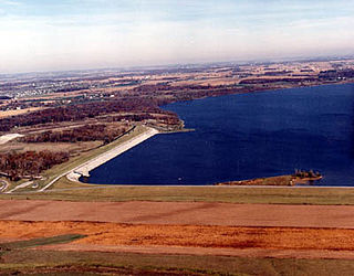
Rathbun Lake was constructed and is operated by the U.S. Army Corps of Engineers. Located at Chariton River mile marker 142, approximately 7 miles north of Centerville, Iowa, in Appanoose County, it is one of the largest lakes in Iowa. The lake was constructed to control flooding, provide recreation opportunities, abate stream pollution, fish and wildlife enhancement, and maintain minimum stream flow on the Chariton, Missouri, and Mississippi Rivers. The Chariton and South Fork of the Chariton River are the major sources of water flowing into Rathbun Lake.

Kanopolis Lake is a reservoir in Ellsworth County in the Smoky Hills of central Kansas, about 31 miles southwest of Salina and a few miles southeast of the town of Kanopolis. The lake is formed by Kanopolis Dam. Completed in 1948 as a flood control and water conservation project of the United States Army Corps of Engineers, the dam impounds the Smoky Hill River.

Council Grove Lake is a reservoir on the Neosho River in east-central Kansas. Built and managed by the U.S. Army Corps of Engineers, it is used for flood control, recreation, and water supply.

Honey Creek State Park is located in Appanoose County, Iowa. The park has a hunting unit, a resort, and a fish hatchery.
Elk Creek is a stream in Clayton County, Iowa and Delaware County, Iowa, in the United States. It is a tributary of the Turkey River.
