Gmina Budzów is a rural gmina in Sucha County, Lesser Poland Voivodeship, in southern Poland. Its seat is the village of Budzów, which lies approximately 8 kilometres (5 mi) north-east of Sucha Beskidzka and 37 km (23 mi) south-west of the regional capital Kraków.
Gmina Maków Podhalański is an urban-rural gmina in Sucha County, Lesser Poland Voivodeship, in southern Poland. Its seat is the town of Maków Podhalański, which lies approximately 7 kilometres (4 mi) east of Sucha Beskidzka and 42 km (26 mi) south-west of the regional capital Kraków.
Gmina Zembrzyce is a rural gmina in Sucha County, Lesser Poland Voivodeship, in southern Poland. Its seat is the village of Zembrzyce, which lies approximately 5 kilometres (3 mi) north of Sucha Beskidzka and 40 km (25 mi) south-west of the regional capital Kraków.

Zakrzewo is a village in the administrative district of Gmina Waganiec, within Aleksandrów County, Kuyavian-Pomeranian Voivodeship, in north-central Poland. It lies 5 kilometres (3 mi) south-west of Waganiec, 13 km (8 mi) south-east of Aleksandrów Kujawski, and 32 km (20 mi) south-east of Toruń.
Teodorów is a village in the administrative district of Gmina Brzeziny, within Brzeziny County, Łódź Voivodeship, in central Poland. It lies approximately 6 kilometres (4 mi) west of Brzeziny and 15 km (9 mi) east of the regional capital Łódź.
Paulinów is a village in the administrative district of Gmina Czerniewice, within Tomaszów Mazowiecki County, Łódź Voivodeship, in central Poland. It lies approximately 3 kilometres (2 mi) north of Czerniewice, 20 km (12 mi) north-east of Tomaszów Mazowiecki, and 49 km (30 mi) east of the regional capital Łódź.
Winiary is a village in the administrative district of Gmina Dwikozy, within Sandomierz County, Świętokrzyskie Voivodeship, in south-central Poland. It lies approximately 6 kilometres (4 mi) north-east of Dwikozy, 12 km (7 mi) north-east of Sandomierz, and 86 km (53 mi) east of the regional capital Kielce.
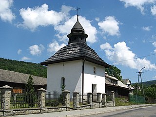
Baczyn is a village in the administrative district of Gmina Budzów, within Sucha County, Lesser Poland Voivodeship, in southern Poland. It lies approximately 12 kilometres (7 mi) north-east of Sucha Beskidzka and 34 km (21 mi) south-west of the regional capital Kraków.
Bieńkówka is a village in the administrative district of Gmina Budzów, within Sucha County, Lesser Poland Voivodeship, in southern Poland. It lies approximately 14 kilometres (9 mi) east of Sucha Beskidzka and 34 km (21 mi) south of the regional capital Kraków.
Jachówka is a village in the administrative district of Gmina Budzów, within Sucha County, Lesser Poland Voivodeship, in southern Poland. It lies approximately 3 kilometres (2 mi) south-east of Budzów, 9 km (6 mi) east of Sucha Beskidzka, and 37 km (23 mi) south-west of the regional capital Kraków.

Palcza is a village in the administrative district of Gmina Budzów, within Sucha County, Lesser Poland Voivodeship, in southern Poland. It lies approximately 14 kilometres (9 mi) north-east of Sucha Beskidzka and 31 km (19 mi) south-west of the regional capital Kraków.
Zachełmna is a village in the administrative district of Gmina Budzów, within Sucha County, Lesser Poland Voivodeship, in southern Poland. It lies approximately 10 kilometres (6 mi) north-east of Sucha Beskidzka and 35 km (22 mi) south-west of the regional capital Kraków.
Bystra is a village in Sucha County, Lesser Poland Voivodeship, in southern Poland. It is the seat of the gmina called Gmina Bystra-Sidzina. It lies approximately 18 kilometres (11 mi) south-east of Sucha Beskidzka and 50 km (31 mi) south of the regional capital Kraków.

Skawica is a village in the administrative district of Gmina Zawoja, within Sucha County, Lesser Poland Voivodeship, in southern Poland, close to the border with Slovakia. It lies approximately 5 kilometres (3 mi) east of Zawoja, 8 km (5 mi) south of Sucha Beskidzka, and 49 km (30 mi) south-west of the regional capital Kraków.
Osielec is a village in the administrative district of Gmina Jordanów, within Sucha County, Lesser Poland Voivodeship, in southern Poland. It lies approximately 6 kilometres (4 mi) west of Jordanów, 15 km (9 mi) south-east of Sucha Beskidzka, and 65 km (40 mi) south of the regional capital Kraków.

Białka is a village in the administrative district of Gmina Maków Podhalański, within Sucha County, Lesser Poland Voivodeship, in southern Poland. It lies approximately 5 kilometres (3 mi) south of Maków Podhalański, 8 km (5 mi) south-east of Sucha Beskidzka, and 46 km (29 mi) south-west of the regional capital Kraków.
Juszczyn is a village in the administrative district of Gmina Maków Podhalański, within Sucha County, Lesser Poland Voivodeship, in southern Poland. It lies approximately 5 kilometres (3 mi) south of Maków Podhalański, 10 km (6 mi) south-east of Sucha Beskidzka, and 45 km (28 mi) south-west of the regional capital Kraków.
Kojszówka is a village in the administrative district of Gmina Maków Podhalański, within Sucha County, Lesser Poland Voivodeship, in southern Poland. It lies approximately 5 kilometres (3 mi) east of Maków Podhalański, 11 km (7 mi) east of Sucha Beskidzka, and 41 km (25 mi) south of the regional capital Kraków.
Żarnówka is a village in the administrative district of Gmina Maków Podhalański, within Sucha County, Lesser Poland Voivodeship, in southern Poland. It lies approximately 4 kilometres (2 mi) east of Maków Podhalański, 11 km (7 mi) east of Sucha Beskidzka, and 40 km (25 mi) south of the regional capital Kraków.
Hucisko is a village in the administrative district of Gmina Stryszawa, within Sucha County, Lesser Poland Voivodeship, in southern Poland. It lies approximately 8 kilometres (5 mi) south-west of Stryszawa, 15 km (9 mi) south-west of Sucha Beskidzka, and 57 km (35 mi) south-west of the regional capital Kraków.


