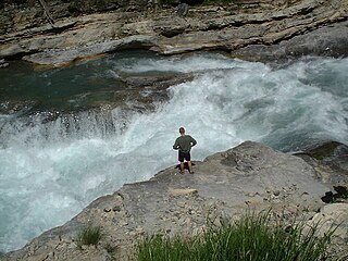
Bull Sluice is a prominent rapid on the Chattooga River on the Georgia and South Carolina border in the United States which was featured in the film Deliverance. Its convenient location off of the US76 bridge makes it a popular destination for whitewater rafters and kayakers. The short hike to the rapid also makes it attractive to spectators. The Bull Sluice area is also a popular swimming hole, and is visited by dozens of swimmers on summer weekends. Swimmers can jump into the rapid, battle the current, or simply relax in the slower water on the S.C. side. Even small children regularly visit to play in the calm water at the edges. There is also a sandy beach a few hundred feet below the rapid. A sandy beach also appears just below Bull Sluice during low water.
Bull Sluice is a benchmark Class IV+ rapid as rated by American Whitewater during normal flow of 1.8 to 2.4 feet.[1] It becomes easier at lower water and significantly more difficult at higher water. Bull Sluice is the largest and final named rapid of Section 3 of the Chattooga River. Since it is one of the more accessible rapids on the river, many boaters who run the narrower and more dangerous Section 4 will first run Bull Sluice before continuing downstream, making the rapid the de facto start of the final section of the river.
A small cave exists under the main flow of the water. Swimmers will often enter the cave during warmer weather to watch boaters run the rapid above them.
Rapids are sections of a river where the river bed has a relatively steep gradient, causing an increase in water velocity and turbulence. Flow, gradient, constriction, and obstacles are four factors that are needed for a rapid to be created.
Whitewater forms in a rapid context, in particular, when a river's gradient changes enough to generate so much turbulence that air is trapped within the water. This forms an unstable current that froths, making the water appear opaque and white.
The Dolores River is a tributary of the Colorado River, approximately 241 miles (388 km) long, in the U.S. states of Colorado and Utah. The river drains a rugged and arid region of the Colorado Plateau west of the San Juan Mountains. Its name derives from the Spanish El Rio de Nuestra Señora de Dolores, River of Our Lady of Sorrows. The river was explored and possibly named by Juan Maria Antonio Rivera during a 1765 expedition from Santa Fe.
The San Miguel River is a tributary of the Dolores River, approximately 81 miles (130 km) long, in southwestern Colorado in the United States. It rises in the San Juan Mountains southeast of Telluride and flows northwest, along the southern slope of the Uncompahgre Plateau, past the towns of Placerville and Nucla and joins the Dolores in western Montrose County approximately 15 miles (24 km) east of the state line with Utah.
The Sandy River is a 56-mile (90 km) tributary of the Columbia River in northwestern Oregon in the United States. The Sandy joins the Columbia about 14 miles (23 km) upstream of Portland.
The Illinois River is a tributary, about 56 miles (90 km) long, of the Rogue River in the U.S. state of Oregon. It drains part of the Klamath Mountains in northern California and southwestern Oregon. The river's main stem begins at the confluence of its east and west forks near Cave Junction in southern Josephine County. Its drainage basin includes Sucker Creek, which rises in the Red Buttes Wilderness, near Whiskey Peak on the California state line. The main stem flows generally northwest in a winding course past Kerby and through the Siskiyou National Forest and Kalmiopsis Wilderness. It joins the Rogue River from the south at Agness on the Curry–Josephine county line, 27 miles (43 km) from the Pacific Ocean.
The Nestucca River flows for about 57 miles (92 km) through forests near the Pacific coast of northwest Oregon in the United States. It drains a timber-producing area of the Northern Oregon Coast Range west of Portland.
Canoe freestyle is a discipline of whitewater kayaking or canoeing where people perform various technical moves in one place, as opposed to downriver whitewater canoeing or kayaking where the objective is to travel the length of a section of river. Specialised canoes or kayaks (boats) known as playboats are often used, but any boat can be used for playing. The moves and tricks are often similar to those performed by snowboarders, surfers or skaters, where the athlete completes spins, flips, turns, etc. With modern playboats it is possible to get the kayak and the paddler completely airborne while performing tricks. The competitive side of playboating is known as freestyle kayaking.
The Chattooga River is the main tributary of the Tugaloo River.
The Narrows of the Green is a 2.9-mile (4.7 km) section of the Green River in Henderson County and Polk County, between the Big Hungry Creek confluence and the Fishtop access area, in western North Carolina, United States. It is roughly 35 miles (56 km) south of downtown Asheville.
The Green River is a dam-release river that flows through the mountains of North Carolina, south of Asheville. The Green has numerous tributaries, but much of its water flows from a confluence with Big Hungry Creek. The Green River is itself a tributary of the Broad River. The river is dammed to form Lake Summit, in Tuxedo, North Carolina, and Lake Adger near Mill Spring, NC. The Green River is named for its deep green color but runs brown after heavy rains.
The Bull Run River is a 21.9-mile (35.2 km) tributary of the Sandy River in the U.S. state of Oregon. Beginning at the lower end of Bull Run Lake in the Cascade Range, it flows generally west through the Bull Run Watershed Management Unit (BRWMU), a restricted area meant to protect the river and its tributaries from contamination. The river, impounded by two artificial storage reservoirs as well as the lake, is the primary source of drinking water for the city of Portland, Oregon.
The Jarbidge River is a 51.8-mile-long (83.4 km), high elevation river in Elko County, Nevada and Owyhee County, Idaho in the United States. The Jarbidge originates as two main forks in the Jarbidge Mountains of northeastern Nevada and then flows through basalt and rhyolite canyons on the high plateau of the Owyhee Desert before joining the Bruneau River.
The Rio Chama, a major tributary river of the Rio Grande, is located in the U.S. states of Colorado and New Mexico. The river is about 130 miles (210 km) long altogether. From its source to El Vado Dam its length is about 50 miles (80 km), from El Vado Dam to Abiquiu Dam is about 51 miles (82 km), and from Abiquiu Dam to its confluence with the Rio Grande is about 34 miles (55 km).
Creeking is a branch of canoeing and kayaking that involves descending very steep low-volume whitewater. It is usually performed in specialized canoes and kayaks specifically designed to withstand the extreme whitewater environment in which the activity occurs. In addition, the canoes and kayaks give the paddler improved performance and maneuverability needed to avoid river obstacles.
The Foothills Trail is a 76-mile (122 km) National Recreation Trail in South and North Carolina, United States, for recreational hiking and backpacking. It extends from Table Rock State Park to Oconee State Park. It passes through the Andrew Pickens Ranger District of the Sumter National Forest, Ellicott Rock Wilderness, Whitewater Falls, and Lake Jocassee.
Upper Dart is a section of the River Dart, Dartmoor. It is perhaps the second most popular section of whitewater for kayakers and canoeists in England, particularly for experienced paddlers. This section is followed on by the Dart Loop.
The Ocoee Whitewater Center, near Ducktown, Tennessee, United States, was the canoe slalom venue for the 1996 Summer Olympics in Atlanta, and is the only in-river course to be used for Olympic slalom competition. A 1,640 foot stretch of the Upper Ocoee River was narrowed by two-thirds to create the drops and eddies needed for a slalom course. Today, the course is watered only on summer weekends, 34 days a year, for use by guided rafts and private boaters. When the river has water, 24 commercial rafting companies take more than 750 raft passengers through the course each day.
This page is based on this Wikipedia article Text is available under the CC BY-SA 4.0 license; additional terms may apply. Images, videos and audio are available under their respective licenses.