Related Research Articles

Olav V Land is a peninsula in eastern Spitsbergen Island, Svalbard named after Olav V of Norway. It is covered by the Olav V Icefield, measuring about 4,150 square kilometres (1,600 sq mi).
Oscar II Land is the land area between Isfjorden and Kongsfjorden on Spitsbergen, Svalbard. The 30 km (19 mi) long glacier Sveabreen divides Oscar II Land from James I Land.
Sabine Land is a land area on the east coast of Spitsbergen, Svalbard. It is named after explorer General Sir Edward Sabine. Among the glaciers in the area is the 250-square-kilometer (97 sq mi) Nordmannsfonna glacier.
James I Land is a land area on the northwestern part of Spitsbergen, Svalbard. It is named after King James I of England and Scotland. The 30 kilometer long glacier Sveabreen divides James I Land from Oscar II Land.
Barentsjøkulen is a glacier on Barentsøya, Svalbard. The glacier covers an area of about 571 km2 (220 sq mi). It is named after the Barents Island, which again is named after Dutch explorer Willem Barentsz. Barents Island is on the Barents Sea.
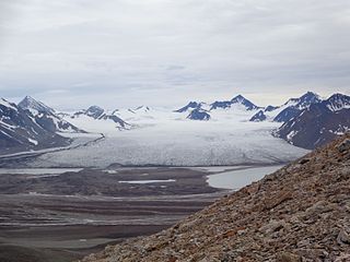
St. Jonsfjorden is a fjord in Oscar II Land at Spitsbergen, Svalbard. It has a length of 21 kilometer, and opens westwards into the strait of Forlandsundet. Several glaciers debouche into the fjord, including Gaffelbreen and Konowbreen from the north, a merge of Osbornebreen, Devikbreen, Vintervegen, Paulbreen and Bukkebreen at the bottom, and Vegardbreen, Charlesbreen and Bullbreen from the south.
Konowbreen is a glacier in Oscar II Land at Spitsbergen, Svalbard. It is located between Carlsfjella and Konowryggen, and debouches into St. Jonsfjorden. The length of the glacier is 12 kilometers. The glacier is named after Wollert Konow.
Vintervegen is a glacier in Oscar II Land at Spitsbergen, Svalbard. It has a length of about 7.5 kilometers (4.7 mi). The glacier borders to the mountain of Klampen, merges with Osbornebreen and other glaciers, and the merged glacier stream debouches into the head of St. Jonsfjorden.
Rabotbreen is a glacier in Sabine Land at Spitsbergen, Svalbard. The glacier is a tributary glacier to Fimbulisen, and is located in the upper part of Sassendalen. Nearby mountains are Bairdfjellet and Moskusryggen.
Uvêrsbreen is a glacier in Oscar II Land at Spitsbergen, Svalbard. It has a length of about 25 kilometers. The glacier debouches into Engelskbukta, after merging with Comfortlessbreen.
Comfortlessbreen is a glacier in Oscar II Land at Spitsbergen, Svalbard. It has a length of about fourteen kilometers, and a maximum width of three kilometers. The glacier debouches into Engelskbukta, after a merge with Uvêrsbreen. Comfortlessbreen is separated from Uvêrsbreen by the mountain range of Trondheimfjella.
Aavatsmarkbreen is a glacier in Oscar II Land at Spitsbergen, Svalbard. It is named after politician and military officer Ivar Aavatsmark. The glacier debouches into Forlandsundet, in the bay of Hornbækbukta. At the southern side of the glacier, between Aavatsmarkbreen and Kaffiøyra, is the mountain range of Prins Heinrichfjella.
Dahlbreen is a glacier in Oscar II Land at Spitsbergen, Svalbard. It is named after whaler Thor Dahl. The glacier has a length of about fifteen kilometers, extending from Løvenskioldfonna to Forlandsundet. Among its tributary glaciers are Ujamnbreen, Bærumbreen and Fjelgbreen. Retreatment of the glacier has formed the bay of Dahlbrebukta.
Eidembreen is a glacier in Oscar II Land at Spitsbergen, Svalbard. It has a length of about eighteen kilometers, and debouches into Eidembukta in Forlandsundet, between St. Jonsfjorden and Isfjorden. The glacier is named after Norwegian politician and naval officer Ole Thorenius Eidem. Eidembreen belongs to the mountain and glacier complex of Trollheimen. Further north are Austgötabreen and Huldrebreen, and to the south are Stallobreen and Heksebreen.
Holmesletfjella is a mountain range in Oscar II Land at Spitsbergen, Svalbard. The range extends about seven kilometers, and comprises several peaks and the four kilometer long ridge of Skipperryggen. Holmesletfjella are located south of St. Jonsfjorden, between Løvliebreen and Bullbreen. They are named after captain and ship owner Hans Holmeslet.
Løvliebreen is a glacier in Oscar II Land at Spitsbergen, Svalbard. It has a length of about five kilometers, and is located between the mountain ranges of Gunnar Knudsenfjella and Holmesletfjella. The glacier debouches northwards towards St. Jonsfjorden. It is named after Norwegian businessperson Andreas Løvlie along with the nearby mountain of Løvliefjellet.
Hydrografbreen is a glacier in Oscar II Land at Spitsbergen, Svalbard. The glacier has a length about eight kilometers, and extends from the mountain range of Holmesletfjella to Jørgenfjellet.
Vestgötabreen is a glacier in Oscar II Land at Spitsbergen, Svalbard. It has a length of about seven kilometers, and is located between Løvliefjellet and the mountain ranges of Holmesletfjella and Motalafjella. The glacier is named from the Swedish province of Västergötland.
Hayesbreen is a glacier in Sabine Land at Spitsbergen, Svalbard. It is named after American politician and Arctic explorer Isaac Israel Hayes. The glacier has a length of about eighteen kilometers, and debouches into the bay of Mohnbukta. Surrounding mountains are Aagaardfjellet to the north, Jebensfjellet to the south, and Panofskyfjellet where Hayesbreen joins the glacier of Königsbergbreen.
Mathiesenfjella is a mountain group in Oscar II Land at Spitsbergen, Svalbard. The group is named after Norwegian businessman Haaken L. Mathiesen.
References
- ↑ "Bullbreen (Svalbard)". Norwegian Polar Institute . Retrieved 18 November 2013.
Coordinates: 78°28′30″N12°39′07″E / 78.475°N 12.652°E
| | This article about a glacier in Spitsbergen is a stub. You can help Wikipedia by expanding it. |