
Reedham is a village and civil parish in the English county of Norfolk and within The Broads. It is on the north bank of the River Yare, some 12 miles (19 km) east of the city of Norwich, 7.5 mi (12.1 km) south-west of the town of Great Yarmouth and the same distance north-west of the Suffolk town of Lowestoft.

Woodhouse, often known to locals as Old Woodhouse, is a small village and civil parish in the heart of Charnwood, England. The population of the civil parish at the 2011 census was 2,319, including around 300 term-time boarders at the Defence College. The parish includes the larger village of Woodhouse Eaves. The parish of Woodhouse was formed in 1844. The village is located between the larger Woodhouse Eaves and Quorn villages, the village contains a mixture of small cottages and large modern houses. It is a commuter village for both Leicester and Loughborough, as well as further afield.
South Killingholme is a village and civil parish in North Lincolnshire, England. The population of the civil parish at the 2011 census was 1,108.

Dalton is a village and civil parish in North Yorkshire in England. Dalton is situated about six miles north-west of Richmond and about five miles south-east of Barnard Castle within the council district of Richmondshire and close to the A66 trans-Pennine trunk road. It was listed in the Domesday book. The Dalton parish boundary includes the village itself as well the houses at Dalton Heights plus numerous surrounding farms. The population of the parish was 147 according to the 2001 census, increasing to 181 at the 2011 Census.

Broomhall is a civil parish in the unitary authority of Cheshire East and the ceremonial county of Cheshire, England. The main line of the Shropshire Union Canal runs through the parish and the River Weaver forms part of its boundary. The main settlement is the hamlet of Broomhall Green, which lies on the A530 about 3.5 miles (5.6 km) south-west of Nantwich. The civil parish has an area of 539 hectares, and also includes part of the small settlement of Sandford, with a total population of around 200 in 2011. Nearby villages include Aston, Sound, Wrenbury and Audlem. Broomhall appears in the Domesday survey and the name was also historically spelled Bromhall.
Bures Hamlet is a civil parish in the Braintree district of Essex, England. At the 2011 census, it had a population of 749.

Wortwell is a village and civil parish in the English county of Norfolk and adjoining the county of Suffolk. It is located on both the River Waveney and the A143 road, some 20 km east of Diss and 30 km west of Lowestoft. The city of Norwich lies approximately 30 km to the north.

Wimbish is a village and civil parish within Uttlesford, in Essex, England. The first recorded mention of the village was in 1042, when it was referred to as Winebisc. It was subsequently referred to as Wimbeis in the Domesday Book. The village has its own non-denominational primary school and a church. The church tower was partly destroyed by lightning in 1756, and was rebuilt in brick but was later taken down again in 1883.

Holtby is a small village and civil parish in the unitary authority of the City of York in North Yorkshire, England. The population at the 2011 Census was 166. It lies close to the A166 about 5 miles (8 km) east of York.

Burrough Green is a village and parish in Cambridgeshire, England. The population of the village at the 2011 census was 378. The soil is various; subsoil, clay and chalk. The chief crops are wheat, barley and roots. The area of the parish is 2,272 acres (919 ha); the population in 1921 was 334."
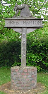
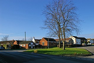
Great Barton is a large village and civil parish in the West Suffolk district of Suffolk, England, about 3 miles (5 km) East of Bury St Edmunds on the A143. At the 2011 census the village had a population of 2,191 rising to 2,236 at the 2018 mid year estimate.

Brent Eleigh is a village and civil parish in the Babergh district of Suffolk, England. Located between Hadleigh and Lavenham, in 2005 it had a population of 180 reducing to 174 at the 2011 Census.

Hunsdon is a village and civil parish in Hertfordshire, England. It is around 5.5 miles (9 km) east of Ware and 5 miles (8 km) north-west of Harlow. The population of the village taken at the 2011 Census was 1,080.

Ballingdon is a suburb of the town of Sudbury in Suffolk, England. Once a separate village in the county of Essex, today it is part of Sudbury civil parish though it was formerly a separate parish. It is the only part of the town to the south of the River Stour. In 1951 the parish had a population of 458.

Great Whelnetham is a village and civil parish in the West Suffolk district of Suffolk in eastern England. Located around two miles south of Bury St Edmunds, in 2005 its population was 820.

Little Whelnetham (well-NEE-thum) is a village and civil parish in the West Suffolk district of Suffolk in eastern England. Located around two miles south of Bury St Edmunds, in 2005 its population was 180.

Ousden is a village and civil parish in the West Suffolk district of Suffolk in eastern England. It is located around six miles west of Bury St Edmunds and 72 miles north of London, and as of 2011, its population is 266. The village has an Anglican church of St Peter's and a chapel in the cemetery dedicated to St Barnabas.

Naughton is a village and former civil parish, now in the civil parish of Nedging-with-Naughton, in the Babergh district, in the county of Suffolk, England. It is 10 miles (16 km) north-west of Ipswich and 7 miles (11 km) south-west of Stowmarket. It was historically within the Cosford Hundred of Suffolk. The civil parish was merged with Nedging in 1935 to create Nedging-with-Naughton. In 1931 the civil parish had a population of 98.

Ropsley and Humby is a civil parish in the South Kesteven district of Lincolnshire, England. According to the 2001 Census it had a population of 808, increasing to 816 at the 2011 census. The parish consists of the small villages of Ropsley and Great Humby and the larger Little Humby, and the Deserted Medieval Villages of Overton Green and Ogarth.
Lenton, Keisby and Osgodby is a civil parish in South Kesteven, Lincolnshire, England. The population of the civil parish at the 2011 census was 187. It is located along the river and in the valleys of the East Glen at its headwaters near Ingoldsby, where several minor streams join together.

