Related Research Articles

Hyde County is a county located in the U.S. state of North Carolina. As of the 2010 Census, the population was 5,810, making it the second-least populous county in North Carolina. Its county seat is Swan Quarter. The county was created in 1705 as Wickham Precinct. It was renamed Hyde Precinct in 1712 and gained county status in 1739.

Carteret County is located in the U.S. state of North Carolina. As of the 2010 census, the population was 66,469. Its county seat is Beaufort. The county was created in 1722 as Carteret Precinct and gained county status in 1739. It was named for Sir George Carteret, one of the 17th century English Lords Proprietor, or for his descendant and heir John Carteret, 2nd Earl Granville.

Brunswick County is the southernmost county in the U.S. state of North Carolina. As of the 2010 census, the population was 107,431. Its population was only 73,143 in 2000, making it one of the fastest growing counties in the state. With a nominal growth rate of about 47% in ten years, much of the growth is centered in the eastern section of the county in the suburbs of Wilmington such as Leland, Belville and Southport. A 2019 estimated population of 142,820 makes Brunswick the 4th-fastest-growing county in the country. The county seat is Bolivia, which at a population of around 150 people is among the least populous county seats in the state.

Newport is a town in Carteret County, North Carolina, United States. The population was 4,510 at the 2010 census.

Pine Knoll Shores is a town in Carteret County, North Carolina, United States. The population was 1,339 at the 2010 census. One of North Carolina's state aquariums is located here.
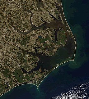
Cape Lookout is the southern point of the Core Banks, one of the natural barrier islands on the Atlantic coast of North Carolina. It delimits Onslow Bay to the west from Raleigh Bay to the east. Core Banks and Shackleford Banks have been designated as parts of the Cape Lookout National Seashore.
Shackleford Banks is a barrier island system on the coast of Carteret County, North Carolina. It contains a herd of feral horses, scallop, crabs and various sea animals, including summer nesting by loggerhead turtles. It is a tourist and beach camping site.
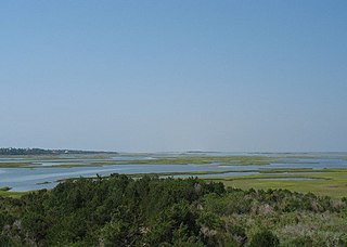
The Core Sound is a lagoon in eastern North Carolina located between the mainland of Carteret County and Core Banks, part of the Outer Banks of North Carolina. It lies between the large Pamlico Sound to the northeast and the smaller Back Sound to the west. Several shifting inlets connect the sound to the Atlantic Ocean.

In North Carolina, the Crystal Coast is an 85-mile stretch of coastline that extends from the Cape Lookout National Seashore, which includes 56 miles of protected beaches, southwestward to the New River. The Crystal Coast is a popular area with tourists and second-home owners in the summer.
Bogue Banks form a 21-mile (34 km) barrier island off the mainland of North Carolina in Carteret County. The island, separated from the mainland by Bogue Sound, runs east to west, with the ocean beaches facing due south. Bogue Banks is the only island on the Carteret County shore that has been developed with housing: numerous communities are located on the island and can be accessed by one of two bridges across Bogue Sound, either from Morehead City to Atlantic Beach, which is the more heavily traveled bridge, or from Cape Carteret to Emerald Isle. The communities of Bogue Banks are the most prominent of the Crystal Coast. NC 58 traverses a majority of the island's length. There are several hotels that dot the island, but most of the land contains private houses, some of which are rented out during the summer, or maritime forest. Stores and other commercial properties are limited to the five main communities.
Bogue Sound is a lagoon in the state of North Carolina separating the Bogue Banks, a 21-mile-long (34 km) barrier island, from the mainland. The sound is part of North Carolina's "Crystal Coast", a tourism marketing term that is also used interchangeably with the term "Southern Outer Banks." It is the southwestern most sound among the interconnected series of sounds along the Outer Banks that starts in the northeast at Currituck Sound.
The Gales Creek area of Carteret County, North Carolina is part of the greater Newport, North Carolina area.
Barden Inlet is the southernmost of the Outer Banks water inlets. Located just northwest of Cape Lookout in the U.S. state of North Carolina, the inlet connects Onslow Bay of the Atlantic Ocean with Core Sound. It separates the Shackleford Banks from the Core Banks.
Drum Inlet and Ophelia Inlet are inlets of the Outer Banks in the U.S. state of North Carolina. They connect the Core Sound with the Atlantic Ocean and separate North Core Banks from South Core Banks. The exact inlet locations and names have changed with time, as new inlets open, merge, or close. Conversationally, the inlet or inlets between mile 19 and 23, as measured from Ocracoke Inlet, are typically called Drum Inlet even when, geologically, they have other names.
Diamond City was a settlement on the eastern end of Shackleford Banks, in Carteret County, North Carolina. Due to the San Ciriaco hurricane that struck in August 1899, the approximately 500 residents of the settlement and island decided to move. The last of the residents had left by 1902, and even relocated houses to nearby places such as Harkers Island, Salter Path and Morehead City.
The Back Sound is a lagoon in eastern North Carolina. Running on an east–west axis, the sound separates Shackleford Banks to the south from the mainland and Harkers Island to the north. At the sound's eastern end lies Cape Lookout and Core Sound, while on the west end lies the Crystal Coast community of Beaufort and Bogue Sound. Barden Inlet at the eastern end, and Beaufort Inlet on the western end connect the sound to Onslow Bay. Much of the islands in the sound are protected as part of the Rachel Carson Estuarine Reserve, set aside for the protection of Banker horses.
HMT Bedfordshire (FY141) was an armed naval trawler in the service of the Royal Naval Patrol Service during World War II. Transferred to the East Coast of the United States to assist the United States Navy with anti-submarine patrols, she was staffed by a British and Canadian crew. Bedfordshire was sunk by the German submarine U-558 on 11 May 1942 off the coast of Ocracoke Island in the Outer Banks of North Carolina, with the loss of all hands.
In North Carolina, Down East refers to two areas of Eastern North Carolina. The first is the historical group of coastal communities east of Beaufort in Carteret County. The second is anywhere east of I-95 in North Carolina in the coastal plain region.

The Core Banks are barrier islands in North Carolina, part of the Outer Banks and Cape Lookout National Seashore. Named after the Coree tribe, they extend from Ocracoke Inlet to Cape Lookout, and consist of two low-relief narrow islands, North Core Banks and South Core Banks, and, since September 2011, two smaller islands. New Drum Inlet, Old Drum Inlet and Ophelia Inlet now separate the islands. The Core Banks are now uninhabited. However, Portsmouth, at the north end of the North Core Banks, was once a substantial port, and Cape Lookout Village, about one and half miles south of the Cape Lookout Lighthouse, contains the historic Lookout Life-Saving Station, a U.S. Coast Guard Station, and several island homes.
Otway in an unincorporated community located in the Straits Township in Carteret County, North Carolina, United States. It is the hub of the Down East region of North Carolina, with a number of businesses including a general store, a hardware store, tire company, services stations, boat supplier, clinic, gym, and library. The community is located near Gillikin Road just west of the intersection of US 70 and Harkers Island Road.
References
- ↑ U.S. Geological Survey Geographic Names Information System: Bunch of Hair
- ↑ Simpson, Bland (1 September 2007). The Inner Islands: A Carolinian's Sound Country Chronicle. Univ of North Carolina Press. p. 11. ISBN 978-0-8078-7674-9.
Coordinates: 34°39′29″N76°33′12″W / 34.658177°N 76.553259°W