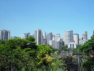
Malanje is the capital city of Malanje Province in Angola with a population of approximately 222,000. It is located 380 kilometres (240 mi) east of Angola's capital Luanda. Near it are the spectacular Calandula waterfalls, the rock formations of Pungo Andongo, and the Capanda Dam. The climate is mainly humid, with average temperatures between 20 and 24 °C and rainfall 900 to 130 millimetres in the rainy season.
Viana is a town and one of the seven municipalities that make up the province of Luanda, as per the new administrative division of the province. Viana lies 15 to 30 kilometers east as a suburb of the capital Luanda and is home to 68.000 inhabitants including about 6,000 long-term refugees, primarily from Katanga Province in the Democratic Republic of the Congo. Viana is about a 90-minute drive from downtown Luanda.

Rail transport in Angola consists of three separate Cape gauge lines that do not connect: the northern Luanda Railway, the central Benguela Railway, and the southern Moçâmedes Railway (southern). The lines each connect the Atlantic coast to the interior of the country. A fourth system once linked Gunza and Gabala but is no longer operational.

Cacuaco is one of the seven municipalities that make up the province of Luanda, as per the new administrative division of the province. It is a suburb of the capital, Luanda. It has a population of 600,000.
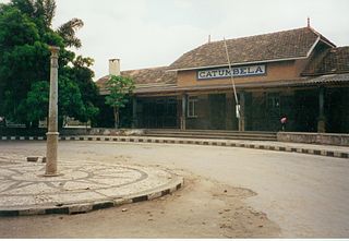
Catumbela is a city and a municipality of the Benguela province in Angola. It has a population of 16,977 as of 2012.

The Luanda Railway is a 424 km single-track Cape gauge railway line from the Angolan capital of Luanda to Malanje. A branch line departs the railway at Zenza do Itombe for Dondo. The line is operated by the state owned company Caminho de Ferro de Luanda E.P., short CFL EP.
Cazenga is the most densely populated of the seven municipalities that make up the province of Luanda, as per the new administrative division of the province. It has a population of 880,369 inhabitants in 2014 Census, with an estimated 1,011,397 in 2018, covering an area of 37 km2.
Musseques are informal settlements in Angola, mostly associated with the sprawling slums around the capital, Luanda
Railway stations in Angola include:
Baia is a small town in Bengo, Angola. It is located on the outskirts of the Angolan capital Luanda.
Funda is a commune/town in the Municipality of Cacuaco of Luanda Province, Angola.

Catete is a town and commune in the municipality of Ícolo e Bengo, province of Luanda, Angola.
Cacuso is a town in Malanje Province, Angola.
Cabiri is a town and commune in the municipality of Ícolo e Bengo, Luanda Province, Angola.

The Estádio 11 de Novembro is a multi-use stadium in Luanda, Angola. Completed in 2010 ahead of the 2010 Africa Cup of Nations, it hosted nine matches during the tournament, including five Group A matches, one group b match, one quarter final, one semi-final, and the final.
Rangel is one of the six urban districts that make up the municipality of Luanda, in the province of Luanda, the capital of Angola.

Angola–India relations refers to the bilateral ties between the India and the Angola. Both nations are part of the Non-Aligned Movement. Being a member of the African Union, Angola supports India's candidature for a permanent seat in a reformed Security Council. India has an embassy in Luanda, Angola. Angola has an embassy in New Delhi, India.

Atlético Petróleos de Luanda is an Angolan multisports club based in Luanda. The club's men's basketball team competes at the local level, at the Luanda Provincial Basketball Championship and at the Angola National Basketball Championship a.k.a. BIC Basket as well as at continental level, at the annual African Basketball Club Champions League competitions.