The Goulburn River National Park is a national park located in New South Wales, Australia, 213 kilometres (132 mi) northwest of Sydney and it is 35 kilometres (22 mi) south-west of Merriwa. The Goulburn River National Park is located in the Hunter Valley region and covers approximately 90 kilometres (56 mi) of the Goulburn River. It is near the towns of Sandy Hollow, Denman, Merriwa, and Mudgee.

The Kanangra-Boyd National Park is a protected national park that is located in the Central Tablelands region, west of the Southern Highlands and Macarthur regions, in New South Wales, in eastern Australia. The 68,660-hectare (169,700-acre) national park is situated approximately 180 kilometres (110 mi) south-west of Sydney and is contiguous with the Blue Mountains National Park and the Nattai National Park. The park was established in 1969.

The Oxley Wild Rivers National Park is a protected national park that is located in the Northern Tablelands region of New South Wales, Australia in the Port Macquarie-Hastings City Council and Walcha Shire councils. The 145,223-hectare (358,850-acre) park is situated 445 kilometres (277 mi) north of Sydney and is named in memory of the Australian explorer John Oxley, who passed through the area in 1818 and is one of the largest national parks in New South Wales.

Onkaparinga River National Park is a protected area in the Australian state of South Australia located about 32 kilometres (20 mi) south of Adelaide city centre. It extends over the floodplain of the Onkaparinga River east of Main South Road.

The Lamington National Park is a national park, lying on the Lamington Plateau of the McPherson Range on the Queensland/New South Wales border in Australia. From Southport on the Gold Coast the park is 85 kilometres (53 mi) to the southwest and Brisbane is 110 kilometres (68 mi) north. The 20,600 hectares Lamington National Park is known for its natural environment, rainforests, birdlife, ancient trees, waterfalls, walking tracks and mountain views. The park protects parts of the Eastern Australian temperate forests.

The Hume Highway, inclusive of the sections now known as the Hume Freeway and Hume Motorway, is one of Australia's major inter-city national highways, running for 840 kilometres (520 mi) between Melbourne in the southwest and Sydney in the northeast. Upgrading of the route from Sydney's outskirts to Melbourne's outskirts to dual carriageway was completed on 7 August 2013.
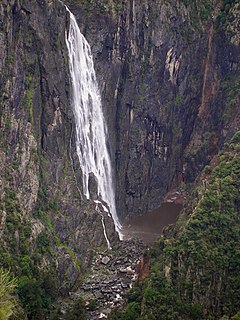
The Wollomombi Falls is a plunge waterfall on the Wollomombi River in the New England region of New South Wales, Australia.
Bungonia Caves are a series of caves near the city of Goulburn, New South Wales, Australia.

The Grose Valley is a rugged valley in the Blue Mountains, New South Wales, Australia. It has been formed by the Grose River, the headwaters of which are in the Mount Victoria area. The valley is located between the Great Western Highway and Bells Line of Road, the two major routes across the Blue Mountains. The majority of the valley falls within the Blue Mountains National Park.
Marulan is the traditional lands of the Gundungurra people. It is a small town in the Southern Tablelands of New South Wales, Australia in the Goulburn Mulwaree Council local government area. It is located south-west of Sydney on the Hume Highway, although it bypasses the town proper. Marulan lies on the 150th meridian east. It has a railway station on the Main Southern railway line. Marulan was previously known as Mooroowoolen.

The Palerang Council was a local government area located in the Southern Tablelands region of New South Wales, Australia. On 12 May 2016 the Minister for Local Government announced dissolution of the Palerang Council with immediate effect. Together with Queanbeyan City the combined council areas were merged to establish the Queanbeyan-Palerang Regional Council. Both councils had opposed the amalgamation. Elections for the new Council area were held in September 2017. The former mayor of Queanbeyan City Council was appointed by the NSW Government as administrator until that date.
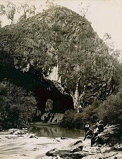
The Abercrombie Caves, contained within the Abercrombie Karst Conservation Reserve, are a series of limestone arch caves that are located in the Central West region of New South Wales, Australia. The caves are renowned for their karst qualities, namely the formation that has been eroded by water action that has developed from a sinkhole to become a blind valley. Several good examples of crayback formations exist in both entrances.

The Wombeyan Caves Road is a New South Wales country road linking Mittagong near the Hume Highway in the east to the Goulburn-Oberon Road at the locality of Richlands in the west. The road is designated as Main Road 258.

Bungonia is a small town in the Southern Tablelands in New South Wales, Australia in Goulburn Mulwaree. At the 2016 census, Bungonia had a population of 367. The name of the town derives from an Aboriginal word meaning 'sandy creek'.

Horsnell Gully Conservation Park is a protected area in the Australian state of South Australia in the locality of Horsnell Gully located about 9 kilometres (5.6 mi) east of the state capital of Adelaide and about 2.3 kilometres (1.4 mi) southwest of Norton Summit.

The Grose River, a perennial river that is part of the Hawkesbury-Nepean catchment, is located in the Blue Mountains region of New South Wales, Australia.

Fossiliferous limestone is any type of limestone, made mostly of calcium carbonate (CaCO3) in the form of the minerals calcite or aragonite, that contains an abundance of fossils or fossil traces. The fossils in these rocks may be of macroscopic or microscopic size. The sort of macroscopic fossils often include crinoid stems, brachiopods, gastropods, and other hard shelled mollusk remains.

Goulburn Mulwaree Council is a local government area located in the Southern Tablelands region of New South Wales, Australia. The area is located adjacent to the Hume Highway and the Southern Highlands railway line. The estimated resident population of the area stood at 29,609 on 2016 census.
Christ Church Anglican Church is a heritage-listed Anglican church at King Street, Bungonia, Goulburn Mulwaree Council, New South Wales, Australia. The current church was designed by William Kemp and built from 1877. The church is administered by St Nicholas Anglican Church, North Goulburn. It was added to the New South Wales State Heritage Register on 1 October 1999.
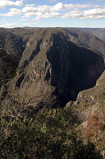
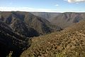
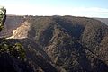
Bungonia National Park is a protected national park that is located in the Australian state of New South Wales, roughly 40 kilometres (25 mi) east of the city of Goulburn and 122 km (76 mi) south-west of Sydney. The approximately 15 square kilometres (5.8 sq mi) park borders the Bungonia State Conservation Area to the South, Morton National Park to the East, and Bungonia Creek to the North. Only a relatively recent addition to the national parks registry, Bungonia was originally protected as a water reserve to prevent contamination of the Shoalhaven River in the mid-late 19th century.