
Loch Lomond is a freshwater Scottish loch which crosses the Highland Boundary Fault, often considered the boundary between the lowlands of Central Scotland and the Highlands. Traditionally forming part of the boundary between the counties of Stirlingshire and Dunbartonshire, Loch Lomond is split between the council areas of Stirling, Argyll and Bute and West Dunbartonshire. Its southern shores are about 23 kilometres (14 mi) northwest of the centre of Glasgow, Scotland's largest city. The Loch forms part of the Loch Lomond and The Trossachs National Park which was established in 2002.

The Merrick, or simply Merrick, is a hill in the Range of the Awful Hand, a sub-range of the Galloway Hills range, part of the Southern Uplands of Scotland. The highest mountain in the Southern Uplands and southern Scotland, the line of sight from Merrick to Snowdon is theoretically the longest in the British Isles.

Carboniferous Limestone is a collective term for the succession of limestones occurring widely throughout Great Britain and Ireland that were deposited during the Dinantian Epoch of the Carboniferous Period. These rocks formed between 363 and 325 million years ago. Within England and Wales, the entire limestone succession, which includes subordinate mudstones and some thin sandstones, is known as the Carboniferous Limestone Supergroup.

Tullibody is a town set in the Central Lowlands of Scotland. It lies north of the River Forth near to the foot of the Ochil Hills within the Forth Valley. The town is 1.8 miles (2.9 km) south-west of Alva, 1.8 miles (2.9 km) north-west of Alloa and 4.0 miles (6.4 km) east-northeast of Stirling. The town is part of the Clackmannanshire council area.
There are many large stones of Scotland of cultural and historical interest, notably the distinctive Pictish stones, but also the other types discussed below.
Chapeltoun is an estate on the banks of the Annick Water in East Ayrshire, Scotland. This is a rural area famous for its milk and cheese production and the Ayrshire or Dunlop breed of cattle.

Dunlop is a village and parish in East Ayrshire, Scotland. It lies on the A735, north-east of Stewarton, seven miles from Kilmarnock. The road runs on to Lugton and the B706 enters the village from Beith and Burnhouse.

The Lomond Hills, also known outwith the locality as the Paps of Fife, are a range of hills in central Scotland. They lie in western central Fife and Perth and Kinross, Scotland. At 522 metres (1,713 ft) West Lomond is the highest point in the county of Fife.

West Lomond is the highest point in the county of Fife, Scotland and the highest peak in the Lomond Hills. Its cone-shaped summit, which is the remains of a volcanic plug, rises above an escarpment of Carboniferous sandstone and limestone layers, capped with a quartz-microgabbro sill. The conspicuous peaks of West Lomond, and its neighbour East Lomond, are visible for many miles around, which explains one suggested origin of their name, the 'Lomond' or 'beacon' hills. On the summit are the remains of an Iron Age hill fort.

A mounting block, horse block, carriage stone, or in Scots a loupin'-on stane is an assistance for mounting and dismounting a horse or cart, especially for women, the young, the elderly or the infirm.
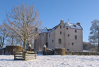
Hatton Castle stands on the lower part of Hatton Hill, the most easterly of the Sidlaw Hills, to the south of Newtyle in Angus, Scotland. The castle overlooks the wooded Den of Newtyle, and its views extend across Strathmore and include Ben Lawers and Schiehallion as well as the Angus and Glenshee hills. The 16th-century castle was originally built in a typical Scottish "Z plan" tower house design, as a fortified country house or château. There was an earlier castle called Balcraig Castle which stood less than half a mile from the present building, also on Hatton Hill.
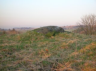
Carlin Stone or Carlin Stane is the name given to a number of prehistoric standing stones and natural stone or landscape features in Scotland. The significance of the name is unclear, other than its association with old hags, witches, and the legends of the Cailleach.

Portmoak is a parish in Kinross-shire, Scotland. It consists of a group of settlements running north to south they are Glenlomond, Wester Balgedie, Easter Balgedie, Kinnesswood, Kilmagadwood and Scotlandwell.
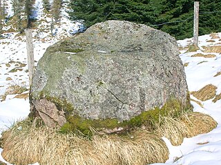
The name gowk stane has been applied to certain standing stones and glacial erratics in Scotland, often found in prominent geographical situations. Other spelling variants, such as gowke, gouk, gouke, goilk, goik, gok, goke, gook are found.

The North Carr Reef is a sandstone reef northeast of Edinburgh, on the headland between the Firth of Forth and St Andrews Bay. There have been many ships wrecked on the reef, which lies on the busy shipping lanes into the Forth ports and the River Tay.

The Caves of Caiplie, Caplawchy or Caiplie Coves, known locally as The Coves are a cave system on the Fife Coastal path between Anstruther and Crail in Scotland. The caves were the site of early Christian worship. After this they were used by farmers to house livestock and as a doocot, around 170 CE. The caves are thought to have been abandoned since 180 CE.
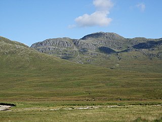
Bidein a' Choire Sheasgaich is a remote 945-metre (3,100 ft) mountain, a Munro, in the Northwest Highlands of Scotland at the western end of an east–west range of hills comprising a Munro Top Meall Mor, the Munro at the highest point of the ridge Lurg Mhòr, and Bidein a' Choire Sheasgaich itself.

Hoy and West Mainland is a national scenic area (NSA) covering parts of the islands of Hoy and Mainland in the Orkney Islands of Scotland, as well as parts of the surrounding sea. It is one of 40 such areas in Scotland, which are defined so as to identify areas of exceptional scenery and to ensure its protection by restricting certain forms of development. The Hoy and West Mainland NSA covers 24,407 ha in total, consisting of 16,479 ha of land with a further 7928 ha being marine.

The Cat Stones of Scotland are natural prominent rock features or standing stones around Scotland that are often linked to battles or burials. The English term cat applied to such stones derives from the Gaelic cath. Clach a'Chait would be the Gaelic for "Stone of the Cat".
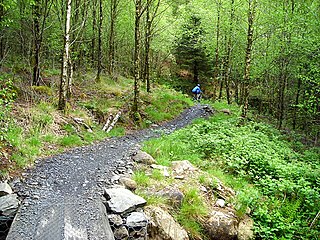
Kirroughtree Forest is located near Newton Stewart in Dumfries and Galloway, southwest Scotland and overlooks the Irish Sea. It is managed by Forestry and Land Scotland and is part of the Galloway Forest Park. It has been developed as a centre for mountain biking trails.
