Bunyala | |
|---|---|
 Bunyala Location of Bunyala | |
| Coordinates: 0°06′N33°58′E / 0.1°N 33.97°E Coordinates: 0°06′N33°58′E / 0.1°N 33.97°E | |
| Country | Kenya |
| County | Busia County |
| Time zone | UTC+3 (EAT) |
Bunyala is a settlement in Kenya's Busia County. [1]
Bunyala | |
|---|---|
| Bunyala Location of Bunyala | |
| Coordinates: 0°06′N33°58′E / 0.1°N 33.97°E Coordinates: 0°06′N33°58′E / 0.1°N 33.97°E | |
| Country | Kenya |
| County | Busia County |
| Time zone | UTC+3 (EAT) |
Bunyala is a settlement in Kenya's Busia County. [1]
The climate is mainly tropical, with variations due to altitude. Kakamega district is mainly hot and wet most of the year, while Bungoma district is colder but just as wet. Busia district is the warmest, while the hilly Vihiga District is the coldest. The entire province experiences very heavy rainfall all year round, with the long rains in the earlier months of the year.

After the 2013 general election, and the coming into effect of the new constitution, provinces became defunct and the country was now divided into 47 counties. Each county has its own government and therefore there is no central regional capital. Western Province became the Western region, comprising four counties: Kakamega, Bungoma, Vihiga, and Busia.
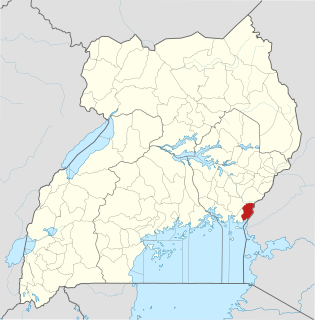
Busia District is a district in the Eastern region of Uganda.

The Iteso are a Nilotic ethnic group in eastern Uganda and western Kenya. Teso refers to the traditional homeland of the Iteso, and Ateso is their language.

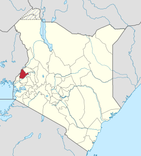
Busia is a county in the former Western Province of Kenya. It borders Kakamega County to the east, Bungoma County to the north, Lake Victoria and Siaya County to the south and Busia District, Uganda to the west. The county has about 893,000 people and spans about 1,700 square kilometers making it one of the smallest counties in Kenya. Busia is inhabited by the Luhya tribe of Kenya and the Teso of Kenya, and small groups of the Luo. The Luhya communities include the Abakhayo, Marachi, Samia and Abanyala communities.

Busia is a town in Kenya. It is the capital and largest town of Busia County.
Bungoma County is a county in the former Western Province of Kenya. Its capital is Bungoma town. It has a population of 1,670,570 of which 812,146 are males 858,389 females as per the 2019 census and an area of 2,069 km2. It has nine constituencies, namely: Bumula, Kabuchai, Kanduyi, Kimilili, Mt. Elgon, Sirisia, Tongaren, Webuye East and Webuye West.

Kisumu County is one of 47 counties in the Republic of Kenya. Its borders follow those of the original Kisumu District, one of the former administrative districts of the former Nyanza Province in western Kenya. Its headquarters is Kisumu City which is the third largest city in Kenya after the capital Nairobi and the coastal city of Mombasa. It has a population of 1,155,574. The land area of Kisumu County totals 2085.9 km2.
West Pokot County is a county of Kenya. Its capital and largest town is Kapenguria. The county covers an area of approximately 9,169.4 square kilometers and stretches a distance of 132 kilometers from North to South. West Pokot County is bordered to the north by Turkana County, to the east by Baringo County, to the southeast by Elgeyo-Marakwet County, to the south by Trans Nzoia County and to the west by Uganda. According to the 2019 census, the county has a population of 621,241. The county is home to Tegla Loroupe, one of the most famous Kenyan female runners.

Baringo County is one of the 47 counties in Kenya. It is located in the former Rift Valley Province. Its headquarters and largest town is Kabarnet. The county is home to Lake Baringo.

Mandera County is the northeasternmost county in Kenya. Its capital and largest town is Mandera. The county is bordered by Ethiopia to the north, Somalia to the east and Wajir County to the southwest. According to the 2019 census, the county has a population of 1,200,890 and an area of 25,939.8 square kilometres (10,015.4 sq mi). The main economic activity in the county is pastoralism, while others include cross-border trade with Ethiopia, artisanal mining, beekeeping, and agriculture along the Dawa River.
Luanda is a market town in the Vihiga County of Kenya, located along the Kisumu-Busia highway. It was one of the administrative divisions in Emuhaya district between 2007 and 2009. Luanda has grown over the past ten years with several banks, and supermarkets establishing within the locality. Luanda serves as the main town for Emuhaya and Luanda subcounties. The predominant tribe in Luanda are the Banyore people.
Busia is a town in the Eastern Region of Uganda. It is the main municipal, administrative, and commercial center of the Busia District, with the district headquarters located there.

Bujwane is a settlement in Kenya's Busia County.
Bukoma is a settlement in Kenya's Busia County.
Bumala is a settlement in Kenya's Busia County.
Bunaba is a settlement in Kenya's Busia County.
Busike is a settlement in Kenya's Busia County.
Nambale is a settlement in Kenya's Busia County. The estimated population is 42,875, and the settlement lies at an elevation of 3,900 feet. Currently, it has continued to expand as there have been talks of construction of a sugar cane factory, to be situated between River Sio and M'nambale stream.
The Musita–Mayuge–Lumino–Majanji–Busia Road is a road in the Eastern Region of Uganda, connecting the town of Musita in Mayuge District to Busia in Busia District at the international border with Kenya.

Port Victoria is a small town in Western Kenya, located in the southern parts of Western province on the shores of Lake Victoria in Busia County just at the Kenya-Uganda border. Fishing is the main economic activity of the people in Port Victoria. The town has a population of 12,194 people and is located at an altitude of about 1,149m.
| | This Western Province (Kenya) location article is a stub. You can help Wikipedia by expanding it. |