Heikkala Lake is an unorganized territory in Saint Louis County, Minnesota, United States. The population was 322 at the 2000 census.

Podlesie is a village in the administrative district of Gmina Walim, within Wałbrzych County, Lower Silesian Voivodeship, in south-western Poland.
George J. Hatfield State Recreation Area is a state park unit on the Merced River Merced County, California. It is located in the San Joaquin Valley about 20 miles (32 km) south of Modesto.
Macculloch Glacier is a glacier located in the northeastern coast of the Baffin Mountains on Baffin Island, Nunavut, Canada.

Arevashogh is a town in the Lori Province of Armenia.

Amberd ; known as Franganots until 1978, is a village in the Armavir Province of Armenia. The village is home to the historic church of Thomas the Apostle, dating back to the 12th century.

Lələbağırlı is a village in the Lachin Rayon of Azerbaijan.
Wymysłów is a village in the administrative district of Gmina Złota, within Pińczów County, Świętokrzyskie Voivodeship, in south-central Poland.
Żarnówka is a village in the administrative district of Gmina Grębków, within Węgrów County, Masovian Voivodeship, in east-central Poland. It lies approximately 17 kilometres (11 mi) south-west of Węgrów and 61 km (38 mi) east of Warsaw.
Półwiosek Stary is a village in the administrative district of Gmina Ślesin, within Konin County, Greater Poland Voivodeship, in west-central Poland. It lies approximately 2 kilometres (1 mi) south of Ślesin, 16 km (10 mi) north of Konin, and 95 km (59 mi) east of the regional capital Poznań.
Oakley is an unincorporated community in St. Mary's County, Maryland, United States. The River View was listed on the National Register of Historic Places in 1976.
Pomlewo is a village in the administrative district of Gmina Przywidz, within Gdańsk County, Pomeranian Voivodeship, in northern Poland. It lies approximately 4 kilometres (2 mi) north-east of Przywidz, 19 km (12 mi) west of Pruszcz Gdański, and 25 km (16 mi) south-west of the regional capital Gdańsk.
Poręby is a village in the administrative district of Gmina Sierakowice, within Kartuzy County, Pomeranian Voivodeship, in northern Poland. It lies approximately 2 kilometres (1 mi) north-west of Sierakowice, 21 km (13 mi) west of Kartuzy, and 49 km (30 mi) west of the regional capital Gdańsk.

Xingshan District is a district of the city of Hegang, Heilongjiang province, China.
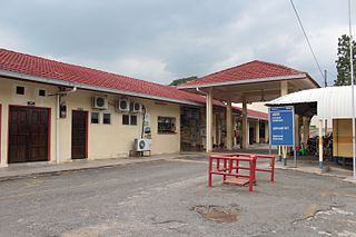
The Jerantut railway station is a Malaysian train station stationed at and named after the town of Jerantut, Pahang.

Crnčići is a village in the municipality of Višegrad, Bosnia and Herzegovina.
Zanožje is a village in the municipality of Višegrad, Bosnia and Herzegovina.
The Second Songua River is a tributary of the Songhua River in Jilin Province, China.

Kreenholm is an island in the Narva River, in the city of Narva belonging to Estonia.
Onemo is an unincorporated community in Mathews County, in the U. S. state of Virginia.