
Dartmoor is an upland area in southern Devon, England. The moorland and surrounding land has been protected by National Park status since 1951. Dartmoor National Park covers 954 km2 (368 sq mi).

The Devonport Leat is a leat in Devon constructed in the 1790s to carry fresh drinking water from the high ground of Dartmoor to the expanding dockyards at Plymouth Dock.

The River Plym is a river in Devon, England. It runs from Dartmoor in the centre of the county southwest to meet the River Meavy, then south towards Plymouth Sound. The river is popular with canoeists, and the Plym Valley Railway runs alongside a section of the river.

Glen Canyon Dam is a concrete arch-gravity dam on the Colorado River in northern Arizona, United States, near the town of Page. The 710-foot (220 m) high dam was built by the U.S. Bureau of Reclamation (USBR) from 1956 to 1966 and forms Lake Powell, one of the largest man-made reservoirs in the U.S. with a capacity of 27 million acre-feet (33 km3). The dam is named for Glen Canyon, a series of deep sandstone gorges now flooded by the reservoir; Lake Powell is named for John Wesley Powell, who in 1869 led the first expedition to traverse the Colorado River's Grand Canyon by boat.

Crazywell Pool or Crazy Well Pool is a large pond situated about 3 km (1.9 mi) south of Princetown just off the path between Burrator and Whiteworks on the western side of Dartmoor, Devon, England at grid reference SX582705. It is about 100 metres (110 yd) long and has a surface area of about 3,500 square metres.
Lake Overholser is a reservoir within the city limits of Oklahoma City, Oklahoma. Lake Overholser is formed by Overholser Dam on the North Canadian River in Oklahoma County, Oklahoma. The lake is 2.9 miles (4.7 km) west of Bethany. Lake Overholser is named after Ed Overholser who was the 16th Mayor of the City of Oklahoma City.

Lake Parramatta is a heritage-listed man-made reservoir and a recreational area located in North Parramatta, City of Parramatta, in the Western Sydney region of New South Wales, Australia. The masonry arch-walled dam across Hunts Creek was completed in 1856 to supply water for domestic purposes; and was operational until 1909. The dam has since been decommissioned and the lake and the surrounding nature reserve are a popular recreational area.

The Somerset Dam is a mass concrete gravity dam with a gated spillway across the Stanley River in Queensland, Australia. It is within the locality of Somerset Dam in the Somerset Region in South East Queensland. The main purpose of the dam is the supply of potable water for the Brisbane, Gold Coast and Logan City regions. Additionally, the dam provides for flood mitigation, recreation and for the generation of hydroelectricity. The impounded reservoir is called Lake Somerset.

The Clywedog Reservoir is a reservoir near Llanidloes, Wales on the head-waters of the River Severn. The construction of the reservoir was enabled by an Act of Parliament which asserted that "At certain times the flow of water in the river is inadequate ... unless that flow were regulated so as to ensure that at those times water in addition to the natural flow will flow down the river." Its primary purpose was to regulate the flow in the River Severn to mitigate flooding and provide support for drinking water abstractions for the West Midlands. It was completed in 1967 and is situated near the B4518 road north of Llanidloes, Powys.
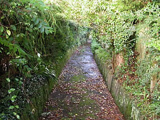
Drake's Leat, also known as Plymouth Leat, was a watercourse constructed in the late 16th century to tap the River Meavy on Dartmoor, England, from which it ran 17.5 miles (28.2 km) in order to supply Plymouth with water. It began at a point now under water at Burrator Reservoir, from which its path now emerges some 10m lower than the typical reservoir water level. It was one of the first municipal water supplies in the country.
The River Meavy is a river in the southwest part of Dartmoor in Devon in south-west England. It runs entirely in the national park and connects Burrator Reservoir to the River Plym.
Meavy is a small village, civil parish and former manor in the English county of Devon. Meavy forms part of the district of West Devon. It lies a mile or so east of Yelverton. The River Meavy runs near the village. For administrative purposes the parish is grouped with the parishes of Sheepstor and Walkhampton to form Burrator Parish Council, and for electoral purposes it is grouped with the same two parishes to form Burrator Ward.

Lake Qaraoun is an artificial lake or reservoir located in the southern region of the Beqaa Valley, Lebanon. It was created near Qaraoun village in 1959 by building a 61 m-high (200 ft) concrete-faced rockfill dam in the middle reaches of the Litani River. The reservoir has been used for hydropower generation, domestic water supply, and for irrigation of 27,500 ha.
Burrator is a grouped parish council in the English county of Devon. It is entirely within the boundaries of the Dartmoor National Park and was formed as a result of the Local Government Act of 1972 from the older councils of Meavy, Sheepstor and Walkhampton.

Sheepstor is a village, civil parish and former manor on the western side of Dartmoor in the county of Devon, England. In 2001, its population was 53, down from 95 in 1901. For administrative purposes the parish is grouped with the parishes of Meavy and Walkhampton to form Burrator Parish Council, and for electoral purposes it is grouped with the same two parishes to form Burrator Ward. Burrator Reservoir, constructed in 1898, is to the north of the village and forms part of the northern boundary of the parish.

Walkhampton is a village and civil parish on the western side of Dartmoor in the county of Devon, England. The village lies on the Black Brook, a tributary of the River Walkham, about 7 kilometres (4.3 mi) south-east of Tavistock, near the villages of Horrabridge, Yelverton and Dousland. Burrator Reservoir, constructed in 1898, is to the south-east.

The Princetown Railway was a 10¼ mile single track branch railway line in Devon, England, that ran from Yelverton on the Plymouth to Tavistock line, to Princetown via four intermediate stations, Dousland, Burrator and Sheepstor Halt, Ingra Tor Halt and King Tor Halt. The line closed in 1956 and today forms part of a popular cycling and walking route.

Upper Tamar lake is a reservoir on the border of Cornwall and Devon in south-west England. It is owned by South West Water and managed by the South West Lakes Trust. The reservoir serves the water supply in the Bude area of Cornwall and surrounding districts, including Clovelly, Bradworthy and Warbstow.
Burrator and Sheepstor Halt railway station was located on the 10.5 mile long single track branch railway line in Devon, England, running from Yelverton to Princetown with eventually four intermediate stations. The station was opened as Burrator Platform and became Burrator Halt when it was opened to the public, the name being changed again in 1929 to Burrator and Sheepstor Halt.

Barrett Dam is a concrete arch-gravity dam in southern San Diego County, California in the United States, forming Barrett Lake on Cottonwood Creek. The dam is part of the city of San Diego's local water supply system.

