
Oxfordshire is a landlocked county in the far west of the government statistical region of South East England. The ceremonial county borders Warwickshire to the north-west, Northamptonshire to the north-east, Buckinghamshire to the east, Berkshire to the south, Wiltshire to the south-west and Gloucestershire to the west.

Warwick is a market town, civil parish and the county town of Warwickshire in the Warwick District in England, adjacent to the River Avon. It is 9 miles (14 km) south of Coventry, and 19 miles (31 km) south-east of Birmingham. It is adjoined with Leamington Spa and Whitnash.
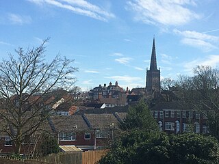
Warwickshire is a county in the West Midlands region of England. The county town is Warwick, and the largest town is Nuneaton. The county is famous for being the birthplace of William Shakespeare at Stratford-upon-Avon and Victorian novelist George Eliot,, at Nuneaton. Other significant towns include Rugby, Leamington Spa, Bedworth, Kenilworth and Atherstone. The county offers a mix of historic towns and large rural areas. It is a popular destination for international and domestic tourists to explore both medieval and more recent history.

Kineton is a village and civil parish on the River Dene in south-east Warwickshire, England. The village is part of Stratford-on-Avon district, and in the 2001 census it had a population of 2,278, increasing to 2,337 at the 2011 Census.

Leek Wootton is a village and former civil parish, now in the parish of Leek Wootton and Guy's Cliffe, in the Warwick district, in the county of Warwickshire, England, approximately 2 miles south of Kenilworth and 2.5 miles north of Warwick. It lies in the triangle created by Kenilworth, Warwick and Leamington Spa. In 1961 the parish had a population of 671.
Coleshill is a market town in the North Warwickshire district of Warwickshire, England, taking its name from the River Cole, on which it stands. It had a population of 6,481 in the 2011 Census and is situated 10 miles (16 km) east-northeast of Birmingham, 8.5 miles (13.7 km) southeast of Sutton Coldfield, 11 miles (18 km) south of Tamworth, 13 miles (21 km) northwest of Coventry by road and 13 miles (21km) west of Nuneaton.

Bidford-on-Avon is a large village and civil parish in the English county of Warwickshire, very close to the border with Worcestershire. In the 2001 census it had a population of 4,830, increasing to 5,350 at the 2011 census.

The River Itchen flows through east Warwickshire in England. It is a small river, about 18 miles (29 km) long, and its general course is from south to north.

Finedon is a town in North Northamptonshire, England, with a population at the 2011 census of 4,309 people. In 1086 when the Domesday Book was completed, Finedon was a large royal manor, previously held by Queen Edith, wife of Edward the Confessor. From the 1860s the parish was much excavated for its iron ore, which lay underneath a layer of limestone and was quarried over the course of 100 years or more. Local furnaces produced pig iron and later the quarries supplied ore for the steel works at Corby. A disused quarry face in the south of the parish is a geological SSSI.
Budbrooke is a small village and civil parish in the Warwick district of Warwickshire, England, about 2½ miles west of Warwick town centre. According to the 2001 census the parish had a population of 2,319, reducing to 1,863 at the 2011 Census. The majority of the population of Budbrooke live in Hampton Magna, a housing estate built in the late 1960s, with other smaller settlements in Budbrooke Village and Hampton on the Hill.
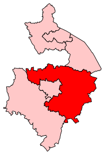
Kenilworth and Southam is a constituency in Warwickshire, England represented in the House of Commons of the UK Parliament since 2010 by Jeremy Wright, a Conservative who served as Culture Secretary until 24 July 2019, having previously served as Attorney General for England and Wales from 2014 to 2018.
Wood End is a former Pit village in North Warwickshire, England. It lies to the south east of Tamworth and close to the border with Staffordshire. It grew around the former Kingsbury Colliery but now it serves as a commuter village to Tamworth. It has a church, a primary school, a co-operative store, a working men's club and a village hall. The population of Wood End is 2,205, but from the 2011 Census has been included in Kingsbury.

The Coventry Way is a 40-mile (64 km) long distance footpath in central England that starts and finishes in Meriden. It forms a circular route around the city of Coventry covering countryside in both the West Midlands and Warwickshire. The path is managed by A Coventry Way Association.

The A423 road is a primary A road in England in two sections. The main section leads from central Banbury to the A45 near Coventry.

Ryton Pools Country Park is a country park one mile south west of the village of Ryton on Dunsmore in Warwickshire, England. The park occupies an area of about 100 acres (0.40 km2) and contains four pools, the largest of which covers approximately 10 acres (40,000 m2). Professional park rangers are employed to look after the varied flora and fauna of the park as well as the general maintenance of pathways and buildings.
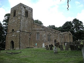
Burton Dassett is a parish and shrunken medieval village in the Stratford-upon-Avon district of Warwickshire, England. The population of the civil parish at the 2011 census was 1,322. Much of the area is now in the Burton Dassett Hills country park. It was enclosed for sheep farming by Sir Edward Belknap and John Heritage at the end of the 15th century. It was the home of Sir Thomas Temple as a child, and for several generations was regarded by the Temple family of Stowe Buckinghamshire as their ancestral home. There is a heraldic memorial to John Temple and his children in Burton Dassett church. Each of the twelve shields represents one of John Temple's children. The left half of each shield represents the husband and the right half represents the wife. The twelfth (undivided) shield represents Temple's son George who died young and therefore did not marry. Susannah Smith, the wife of agriculturalist Jethro Tull was born in the village.

The River Dene is a small river in Warwickshire, England.

Northend is a village in southern-eastern Warwickshire, England, located roughly halfway between the town of Banbury and the conurbation of Leamington Spa and Warwick. The population taken at the 2011 census can be found under Burton Dassett. Situated at the foot of the Burton Dassett Hills, which contains Burton Dassett Country Park, it is less than a mile east of the M40 motorway. The M40 is about 8 minutes away. There was once a primary school in the village, but this was controversially closed by the LEA due to a claimed lack of pupils, and it has now been converted into a house. There were two churches in the village, a Church of England building, known as the Chapel of Ease, and Northend Methodist Chapel, which has now been converted into a house.

Ratley is a village in the civil parish of Ratley and Upton, Stratford-on-Avon District, Warwickshire, England. The population of the civil parish in 2011 was 327. It is on the northwest side of the Edge Hill escarpment about 200 metres (660 ft) above sea level. The village is close to the county border with north Oxfordshire, some 7 miles northwest of Banbury, the closest town.
Burton Dassett Halt was a railway station on the former Stratford-upon-Avon and Midland Junction Railway in Warwickshire, England.


