Buses in Lowestoft

Last updated

Buses in Lowestoft in the English county of Suffolk provide public transport in and around the town. Buses were first introduced in the town by Lowestoft Corporation Tramways in 1927 and replaced original tram services by 1931.

Lowestoft town in Suffolk, England

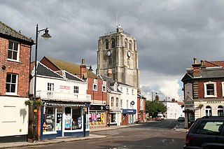
Lowestoft is an English town and civil parish in the county of Suffolk. The town, on the North Sea coast, is the most easterly settlement of the United Kingdom. It is 110 miles (177 km) north-east of London, 38 miles (61 km) north-east of Ipswich and 22 miles (35 km) south-east of Norwich. It lies on the edge of The Broads system and is the major settlement in the district of Waveney, with a population of 71,010 in 2011. Some of the earliest evidence of settlement in Britain has been found here. As a port town it developed out of the fishing industry and as a traditional seaside resort. It has wide, sandy beaches, two piers and other attractions. While its fisheries have declined, oil and gas exploitation in the southern North Sea in the 1960s added to its development, as a base for the industry alongside nearby Great Yarmouth. This role has declined, but the town has begun to develop as an Eastern England centre of the renewable energy industry.

Suffolk County of England

Suffolk is an East Anglian county of historic origin in England. It has borders with Norfolk to the north, Cambridgeshire to the west and Essex to the south. The North Sea lies to the east. The county town is Ipswich; other important towns include Lowestoft, Bury St Edmunds, Newmarket and Felixstowe, one of the largest container ports in Europe.

Lowestoft Corporation Tramways was the operator of the electric tramway system that served Lowestoft from 22 July 1903 until 8 May 1931.

The corporation became Waveney District Council in 1974 and bus services taken over by Eastern Counties in 1977. [1] The bus garage is on Rotterdam Road is still standing. [2]

First Norfolk & Suffolk

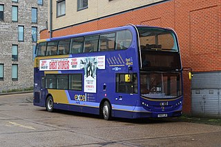
First Eastern Counties, trading as First Norfolk & Suffolk, is a bus operator providing services in Norfolk and Suffolk in eastern England. It is a subsidiary of FirstGroup.

After bus deregulation in 1986 a range of operators took over services. In 2013 bus services in the town were operated by First Eastern Counties, Anglian Bus and Coaches, Nightingales of Beccles, Belle Coaches and Ambassador Travel. [3] Routes within the town generally operate along key corridors linking the town centre with areas around the edge of the town. [4] Services generally operate regularly during the day, becoming significantly less frequent during the evening. [4] Some services, such as an orbital route around the town, are part funded by public money. [5]

Anglian Bus bus operator based in Beccles in the English county of Suffolk

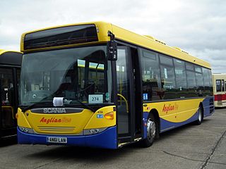
Anglian Bus was a bus operator based in Beccles. A subsidiary of the Go-Ahead Group, it operated services in both Norfolk and Suffolk from 1981 until 2017.

Bus services tend to be focussed on the bus station in the town centre, although the redevelopment of Lowestoft railway station aims to make the station a key interchange for bus routes as well. [4] [6] Traffic congestion, especially difficulty crossing Lake Lothing which cuts the town in two, can cause delays to bus services. [4] Bus routes also connect the town to Norwich, Great Yarmouth and Peterborough as well as to surrounding villages and market towns and tourist destinations such as Pleasurewood Hills. [3] [7]

Lowestoft railway station Railway Station in Suffolk, England

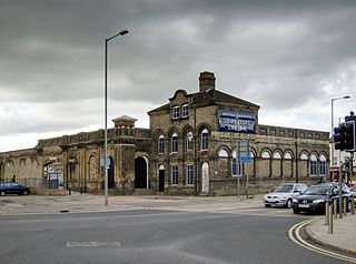
Lowestoft railway station serves the town of Lowestoft, Suffolk, and is the eastern terminus of the East Suffolk Line from Ipswich and is one of two eastern termini of the Wherry Lines from Norwich. Lowestoft is 23 miles 41 chains (37.8 km) down the line from Norwich and 48 miles 75 chains (78.8 km) measured from Ipswich; and is the easternmost station on the National Rail network in the United Kingdom.

Lake Lothing lake in the United Kingdom

Lake Lothing is a saltwater lake located in Lowestoft in the English county of Suffolk. The lake, which is believed to be the remnant of medieval peat cutting, flows into the North Sea and forms part of the Port of Lowestoft. The area was the major industrial centre of Lowestoft with ship building and other engineering industries, much of which has now closed.

Norwich City and non-metropolitan district in England

Norwich is a historic city in Norfolk, England. Situated on the River Wensum in East Anglia, it lies approximately 100 miles (161 km) north-east of London. It is the county town of Norfolk and is considered the capital of East Anglia, with a population of 141,300. From the Middle Ages until the Industrial Revolution, Norwich was the largest city in England after London, and one of the most important.

Related Research Articles

East Anglia region of the United Kingdom of Great Britain and Northern Ireland

East Anglia is a geographical area in the East of England. The area included has varied but the legally defined NUTS 2 statistical unit comprises the counties of Norfolk, Suffolk and Cambridgeshire, including the City of Peterborough unitary authority area. The name derives from the Anglo-Saxon kingdom of the East Angles, a tribe whose name originated in Anglia, northern Germany.

Beccles market town and civil parish in the Waveney District of the English county of Suffolk

Beccles is a market town and civil parish in the Waveney district of the English county of Suffolk. The town is shown on the milestone as 109 miles (175 km) from London via the A145 and A12 roads, 98 miles (158 km) northeast of London as the crow flies, 16 miles (26 km) southeast of Norwich, and 33 miles (53 km) north northeast of the county town of Ipswich. Nearby towns include Lowestoft to the east and Great Yarmouth to the northeast. The town lies on the River Waveney on the edge of The Broads National Park.

East Suffolk line

The East Suffolk line is an un-electrified 49-mile secondary railway line running between Ipswich and Lowestoft in Suffolk, England. The traffic along the route consists of passenger services operated by Greater Anglia, while nuclear flask trains for the Sizewell nuclear power stations are operated by Direct Rail Services.

Wherry Lines railway lines in England

The Wherry Lines are railway branch lines in the East of England, linking Norwich to Great Yarmouth and Lowestoft. There are 14 stations including the three termini. They form part of Network Rail Strategic Route 7, SRS 07.11 and are classified as a rural line.

Great Yarmouth railway station railway station

Great Yarmouth railway station is one of two eastern termini of the Wherry Lines in the East of England, serving the seaside town of Great Yarmouth, Norfolk. The other terminus at the eastern end of the lines is Lowestoft, and the western terminus to which all trains run is Norwich.

A146 road road

The A146 is an A road that connects Norwich in Norfolk and Lowestoft in Suffolk, two of East Anglia's largest population centres. It is around 27 miles (43 km) in length and has primary classification along its entire route. It is mainly single carriageway throughout its route, with the exception of a section of dual carriageway on the southern edge of Norwich.

Norwich Bus Station

Norwich Bus Station is situated off Surrey Street and Queen's Road, Norwich, Norfolk, England. It is served by a number of bus operators, such as Konectbus, Norse, Simonds, First Norfolk & Suffolk, National Express, Megabus and City Sightseeing Norwich.

Yarmouth South Town railway station

Yarmouth South Town, sometimes known as Yarmouth Southtown, was a railway station in Great Yarmouth, England, that is now closed. It was one of three major stations in the town, the others being Yarmouth Vauxhall and Yarmouth Beach, of which only Yarmouth Vauxhall now remains.

The Yarmouth–Lowestoft line was an East Anglian railway line which linked the coastal towns of Yarmouth and Lowestoft. It opened on 13 July 1903 as the first direct railway link between the two towns and was constructed by the Great Eastern Railway and the Midland and Great Northern Railway in the hope of encouraging the development of holiday resorts along the coast. In the event, although the line was built to high standards and considerable cost, intermediate traffic did not develop and competition from buses and trams eroded the little that had been generated. Fish traffic was carried in large quantities until the 1930s when it fell into decline. In 1953, when major repairs to the Breydon Viaduct were required, it was decided to discontinue through services from the Midland and Great Northern to Lowestoft and to divert London trains to Lowestoft via Norwich. After the Midland and Great Northern and Yarmouth–Beccles line closed to passengers in 1959, the Yarmouth–Lowestoft line was upgraded to accommodate the diverted traffic, but after services were switched to Yarmouth Vauxhall in 1962, it was singled and the stations made unstaffed halts. With only a local service running between vandalised stations, the decision was taken to close the route on 4 May 1970 in favour of bus services which were judged adequate for most of the year.

Transport in Ipswich

Ipswich is the county town of Suffolk, England. It is a medieval port and industrial town with a strong transport history; the urban area has a population of 122,000 and currently offers urban transport services for cars, cycles and buses. In addition there are 3 railway stations and regional coach services. Stansted Airport is accessible by the airlink coach.

Excel (bus network)

Excel is the brand name given to a number of bus services operated by First Norfolk & Suffolk, covering 107 miles (172 km) between Lowestoft bus station in Suffolk and Peterborough railway station in Cambridgeshire. Prior to February 2018, the main section of route was provided as a single service, but has now been split for operational reasons into the excel route itself between Peterborough, King's Lynn and Norwich, and the X1 between Norwich, Great Yarmouth and Lowestoft.

The Norfolk & Suffolk League was a football league covering the counties of Norfolk and Suffolk in England.

The East Anglian League was a football league in the East Anglia region of England.

Transport in East Anglia

Transport in East Anglia consists of extensive road and rail networks as well as one of England's key regional airports and the country's busiest container port. Despite having very little motorway within their borders, the counties of Suffolk, Norfolk and Cambridgeshire have modern transport links with the rest of the country.

Southwold Lifeboat Station

Southwold Lifeboat Station is an RNLI operated lifeboat station located in the town of Southwold in the English county of Suffolk.

Anglian Radio is a media company based in Ipswich, Suffolk. The group was created after Tindle Radio sold many of its radio stations in the East of England.

References

  1. Lowestoft Corporation Transport, Peter Gould. Retrieved 16 January 2013.
  2. White, Malcolm R. (2005). Lowestoft Corporation Transport. Coastal Publications. ISBN   978-0-9532485-9-9.
  3. 1 2 Lowestoft & surrounding area Archived 12 January 2013 at the Wayback Machine ., Suffolk onboard, Suffolk County Council. Retrieved 16 January 2013.
  4. 1 2 3 4 Lowestoft transport strategy Archived 27 March 2014 at the Wayback Machine ., Suffolk County Council, 29 June 2011. Retrieved 26 January 2013.
  5. Lowestoft's £6.25m for transport but no third road bridge, BBC Suffolk news website, 13 October 2011. Retrieved 26 January 2013.
  6. Lowestoft railway station's £1m interchange work, BBC Suffolk news website, 25 January 2013. Retrieved 26 January 2013.
  7. Lowestoft bus services receive revamp in push towards sustainable transport, Eastern Daily Press, 12 May 2012. Retrieved 16 January 2013.