
The Northwest Passage (NWP) is the sea lane between the Atlantic and Pacific oceans through the Arctic Ocean, near the northern coast of North America via waterways through the Arctic Archipelago of Canada. The eastern route along the Arctic coasts of Norway and Siberia is accordingly called the Northeast Passage (NEP). The various islands of the archipelago are separated from one another and from mainland Canada by a series of Arctic waterways collectively known as the Northwest Passages, Northwestern Passages or the Canadian Internal Waters.

The history of Greenland is a history of life under extreme Arctic conditions: currently, an ice sheet covers about eighty percent of the island, restricting human activity largely to the coasts. The first humans are thought to have arrived in Greenland around 2500 BCE. Their descendants apparently died out and were succeeded by several other groups migrating from continental North America. There has been no evidence discovered that Greenland was known to Norsemen until the ninth century CE, when Norse Icelandic explorers settled on its southwestern coast. The ancestors of the Greenlandic Inuit who live there today appear to have migrated there later, around the year 1200, from northwestern Greenland.

Denmark and the former real union of Denmark–Norway had a colonial empire from the 17th through to the 20th centuries, large portions of which were found in the Americas. Denmark and Norway in one form or another also maintained land claims in Greenland since the 13th century, the former up through the twenty-first century.

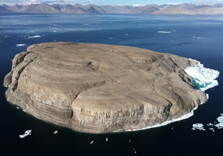
Ellesmere Island is Canada's northernmost and third largest island, and the tenth largest in the world. It comprises an area of 196,236 km2 (75,767 sq mi), slightly smaller than Great Britain, and the total length of the island is 830 km (520 mi).

Sir Martin Frobisher was an English sailor and privateer who made three voyages to the New World looking for the North-west Passage. He probably sighted Resolution Island near Labrador in north-eastern Canada, before entering Frobisher Bay and landing on present-day Baffin Island.
The exploration of North America by Norsemen began in the late 10th century when they explored areas of the North Atlantic, colonized Greenland, and created a short-term settlement near the northern tip of Newfoundland. The remains of buildings were found at L'Anse aux Meadows in 1960 dating to approximately 1,000 years ago. This discovery helped reignite archaeological exploration for the Norse in the North Atlantic. This single settlement, located on the island of Newfoundland and not on the North American mainland, was abruptly abandoned.
Hans Island is an island in the centre of the Kennedy Channel of Nares Strait in the high Arctic region, split between the Canadian territory of Nunavut and the Danish autonomous territory of Greenland. The island itself is barren and uninhabited with an area of 130 hectares, measuring 1,290 by 1,199 metres, and a maximum elevation of 168.17 m (551.7 ft). Its location in the strait that separates Ellesmere Island of Canada from northern Greenland was for years a border dispute, the so-called Whisky War between the two countries of Canada and Denmark. Hans Island is the smallest of three islands in Kennedy Channel off the Washington Land coast; the others are Franklin Island and Crozier Island. The strait at this point is 35 km (22 mi) wide, placing the island within the territorial waters of both Canada and Denmark (Greenland). A 1,280-metre-long (4,200 ft) shared border traverses the island.
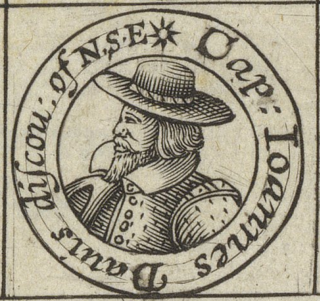
John Davis was one of the chief navigators of Queen Elizabeth I of England. He led several voyages to discover the Northwest Passage and served as pilot and captain on both Dutch and English voyages to the East Indies. He discovered the Falkland Islands in August 1592.

Baffin Bay, located between Baffin Island and the west coast of Greenland, is defined by the International Hydrographic Organization as a marginal sea of the Arctic Ocean. It is sometimes considered a sea of the North Atlantic Ocean. It is connected to the Atlantic via Davis Strait and the Labrador Sea. The narrower Nares Strait connects Baffin Bay with the Arctic Ocean. The bay is not navigable most of the year because of the ice cover and high density of floating ice and icebergs in the open areas. However, a polynya of about 80,000 km2 (31,000 sq mi), known as the North Water, opens in summer on the north near Smith Sound. Most of the aquatic life of the bay is concentrated near that region.
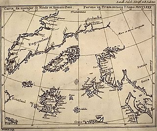
Frisland, also called Frischlant, Friesland, Frislanda, Frislandia, or Fixland, is a phantom island that appeared on virtually all of the maps of the North Atlantic from the 1560s through the 1660s. It was removed as no Frisland was found as the area was more thoroughly explored and navigation increased. Accurate navigation was more difficult in this time, and it might of originated from a misidentification of Iceland or Greenland.
John Scolvus or John of Kolno may have been a navigator of the late 15th century. According to some sources he was among a group of early Europeans to reach the shores of the Americas prior to Columbus, arriving in 1476 as steersman of Didrik Pining, although this view is not supported by contemporary evidence; as he is not mentioned contemporaneously, his identity and even existence have been disputed.

Iqaluit Airport serves Iqaluit, Nunavut, Canada and is located adjacent to the city. It hosts scheduled passenger service from Ottawa, Montreal, Rankin Inlet, and Kuujjuaq on carriers such as Canadian North, and from smaller communities throughout eastern Nunavut. It is also used as a forward operating base by the Royal Canadian Air Force (RCAF). In 2011, the terminal handled more than 120,000 passengers.

Ejnar Mikkelsen was a Danish polar explorer and writer. He is most known for his expeditions to Greenland.

Arctic exploration is the physical exploration of the Arctic region of the Earth. It refers to the historical period during which mankind has explored the region north of the Arctic Circle. Historical records suggest that humankind have explored the northern extremes since 325 BC, when the ancient Greek sailor Pytheas reached a frozen sea while attempting to find a source of the metal tin. Dangerous oceans and poor weather conditions often fetter explorers attempting to reach polar regions, and journeying through these perils by sight, boat, and foot has proven difficult.

Christian IV's expeditions were sent by King Christian IV of Denmark-Norway to Greenland and Arctic waterways during the years 1605–1607. The expeditions were commissioned in order to locate the lost Eastern Norse Settlement and reassert sovereignty over Greenland.

This timeline of European exploration lists major geographic discoveries and other firsts credited to or involving Europeans during the Age of Discovery and the following centuries, between the years AD 1418 and 1957.

King Frederick VI Coast is a major geographic division of Greenland. It comprises the coastal area of Southeastern Greenland in Sermersooq and Kujalleq municipalities fronting the Irminger Sea of the North Atlantic Ocean. It is bordered by King Christian IX Land on the north and the Greenland Ice Sheet to the west.

The Peary Channel was a hypothetical sound or marine channel running from east to west separating Peary Land in northernmost Greenland from the mainland further south.

Kodlunarn Island, known as Qallunaaq in Inuktitut and originally named Countess of Warwick Island, is a small island located in Frobisher Bay in the Canadian territory of Nunavut. During the 1570s, explorer Martin Frobisher led expeditions to the island to mine what he believed was gold ore. The ore turned out to be worthless, and the island was ignored by explorers until Charles Francis Hall, inspired by oral history accounts from the Inuit of Frobisher Bay, visited the site in 1861 to investigate the remains of Frobisher's expeditions. Notable features of the island include two large mining trenches and the remains of a stone house built by Frobisher in 1578. Kodlunarn Island was designated a National Historic Site of Canada in 1964.

