Related Research Articles

Gordonvale is a rural sugar-growing town and locality situated on the southern side of Cairns in the Cairns Region, Queensland, Australia. In the 2021 census, the locality of Gordonvale had a population of 6,944 people.

Moura is a rural town and locality in the Shire of Banana in Central Queensland, Australia. It services the surrounding coal mining and rural activities. It is situated approximately 65 kilometres (40 mi) west of Biloela on the Dawson Highway, 186 kilometres (116 mi) west of the port city of Gladstone, and 171 kilometres (106 mi) south west of Rockhampton. As of the 2021 census, the locality of Moura had a population of 1,993 people.

Laura is a rural town and locality in the Shire of Cook, Queensland, Australia. In the 2016 census the locality of Laura had a population of 228 people.

Lakeland is a rural town and locality in the Shire of Cook, Queensland, Australia. In the 2016 census, the locality of Lakeland had a population of 299 people.

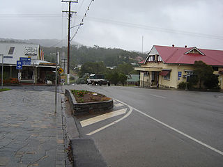
Coen is a rural town and coastal locality in the Shire of Cook, Queensland, Australia. The town of Coen is inland on the Peninsula Developmental Road, the main road on the Cape York Peninsula in far northern Queensland. In the 2021 census, the locality of Coen had a population of 320.
Herberton is a rural town and locality in the Tablelands Region, Queensland, Australia. In the 2016 census, the locality of Herberton had a population of 855 people.

Far North Queensland (FNQ) is the northernmost part of the Australian state of Queensland. Its largest city is Cairns and it is dominated geographically by Cape York Peninsula, which stretches north to the Torres Strait, and west to the Gulf Country. The waters of Torres Strait include the only international border in the area contiguous with the Australian mainland, between Australia and Papua New Guinea.
Babinda is a rural town and locality in the Cairns Region, Queensland, Australia. Babinda and Tully annually compete for the Golden Gumboot, an award for Australia's wettest town. Babinda is usually the winner, recording an annual average rainfall of over 4,279.4 millimetres (168.48 in) each year. In the 2021 census, the locality of Babinda had a population of 1,287 people.

The Palmer River is a river in Far North Queensland, Australia. The area surrounding the river was the site of a gold rush in the late 19th century which started in 1873.
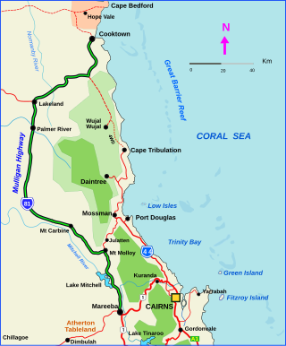
The Mulligan Highway is a state highway in Queensland, Australia. It runs for approximately 266 km between Mareeba and Cooktown, on the east coast of Cape York Peninsula where it terminates. It is signed as State Route 81 from Mareeba to Lakeland and State Route 40 from Lakeland to Cooktown. It is a state-controlled regional road.
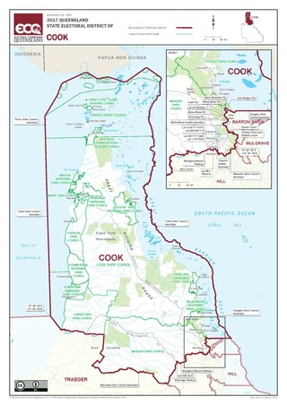
Cook is an electoral district in Queensland, Australia.

The Normanby River, comprising the East Normanby River, the West Normanby River, the East Normanby River North Branch, the East Normanby River South Branch and the Granite Normanby River, is a river system in Far North Queensland, Australia.

Mount Surprise is a rural town and locality in the Shire of Etheridge, Queensland, Australia. In the 2016 census, the locality of Mount Surprise had a population of 169 people.

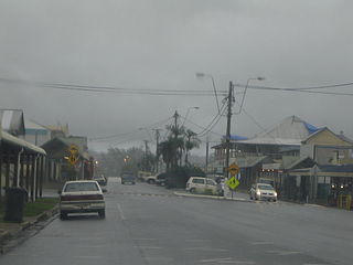
Cooktown is a coastal town and locality in the Shire of Cook, Queensland, Australia. Cooktown is at the mouth of the Endeavour River, on Cape York Peninsula in Far North Queensland where James Cook beached his ship, the Endeavour, for repairs in 1770. Both the town and Mount Cook which rises up behind the town were named after James Cook.
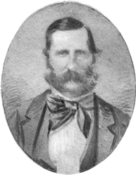
John Frederick McDougall (1820—1896) was a pastoralist and politician in Queensland, Australia. He was a Member of the Queensland Legislative Council.
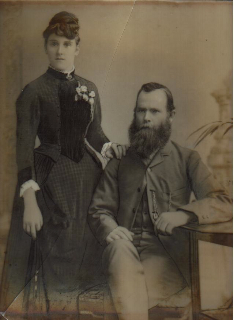
William Lakeland was an Australian explorer and prospector in the late 19th and early 20th century.

Manoora is a suburb of Cairns in the Cairns Region, Queensland, Australia. In the 2021 census, Manoora had a population of 6,175 people.

Feluga is a rural locality in the Cassowary Coast Region, Queensland, Australia. In the 2021 census, Feluga had a population of 306 people.

Wrights Creek is a rural locality in the Cairns Region, Queensland, Australia. In the 2021 census, Wrights Creek had a population of 160 people.

James Earl (?-1907) was a merchant in Far North Queensland of cartage and started cattle breeding.
References
- ↑ "Notes on the Cooktown Show". Cairns Post. 1910-06-21. Retrieved 2024-05-31.
- ↑ "PENINSULA PAGES". Cairns Post. 1940-08-21. Retrieved 2024-05-31.
- ↑ "PERSONAL". Northern Miner. 1915-09-16. Retrieved 2024-05-31.
- ↑ "THE SKETCHER". Queenslander. 1896-02-01. Retrieved 2024-06-08.
- ↑ "Cairns Post (Qld. : 1909 - 1954) - 29 Jan 1929 - p9". Trove. Retrieved 2024-05-31.
- ↑ Queensland Family History Society (2010), Queensland schools past and present (Version 1.01 ed.), Queensland Family History Society, ISBN 978-1-921171-26-0
- ↑ "ArchivesSearch | Queensland State Archives | Queensland Government". www.archivessearch.qld.gov.au. Retrieved 2023-02-19.
- ↑ Wallace, Lennie (2012). The Battlers of Butcher's Hill. Boolarong Press. Appendix. ISBN 978-1-921920-69-1 . Retrieved 19 February 2023.