Porth is a town and a community in the county borough of Rhondda Cynon Taf, within the historic county boundaries of Glamorgan, Wales, lying in the Rhondda Valley and is regarded as the gateway to the Rhondda Fawr and Rhondda Fach valleys because both valleys meet at Porth. The Welsh word "porth" means "gate". Porth is a predominantly English-speaking community.

Treorchy is a village and community in Wales. Once a town, it retains the characteristics of a town. Situated in the county borough of Rhondda Cynon Taf in the Rhondda Fawr valley. Treorchy is also one of the 16 communities of the Rhondda. It includes the villages of Cwmparc and Ynyswen.

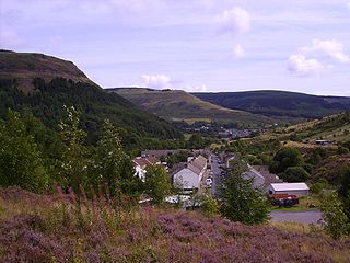
Rhondda, or the Rhondda Valley, is a former coal mining area in South Wales, previously in Glamorgan, and now a local government district, consisting of 16 communities built around the River Rhondda. The Rhondda is actually two valleys—the larger Rhondda Fawr valley and the smaller Rhondda Fach valley. The singular term 'Rhondda Valley' and the plural 'Rhondda Valleys' are both commonly used. In 2001, the Rhondda constituency of the National Assembly for Wales had a population of 72,443; while the National Office of Statistics described the Rhondda urban area as having a population of 59,602. Rhondda is part of Rhondda Cynon Taf County Borough and is part of the South Wales Valleys.
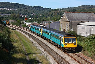
The Rhondda line is a commuter railway line in South Wales from Cardiff to Treherbert. The line follows the Merthyr line as far as Pontypridd, where it then diverges to continue along the Rhondda Valley.
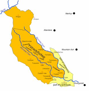
Ystradyfodwg was an ancient upland parish in Glamorgan, Wales. It is believed to have been named after Tyfodwg who was either a 7th-century saint or chieftain.

Porth railway station is a railway station serving the town of Porth in Rhondda Cynon Taf, Wales. It is located on the Rhondda Line.

Treherbert railway station is a railway station serving the village of Treherbert in Rhondda Cynon Taf, Wales. It is the northern terminus of the Rhondda Line 23 miles (37 km) north west of Cardiff Central.

Tower Colliery was the oldest continuously working deep-coal mine in the United Kingdom, and possibly the world, until its closure in 2008. It was the last mine of its kind to remain in the South Wales Valleys. It was located near the villages of Hirwaun and Rhigos, north of the town of Aberdare in the Cynon Valley south Wales.

Dinas is a village near Tonypandy in the county borough of Rhondda Cynon Taf, Wales. Dinas is often referred to as Dinas Rhondda to avoid confusion with Dinas Powys in the Vale of Glamorgan. The word dinas in Modern Welsh means "city", but here it means "hill fort".
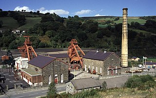
Rhondda Heritage Park, Trehafod, Rhondda, South Wales is a tourist attraction which offers an insight into the life of the coal mining community that existed in the area until the 1980s.
Dare Valley Country Park is a public park in Wales. It lies near the village of Cwmdare and the town of Aberdare, Cynon Valley, in Rhondda Cynon Taff, South Wales. It comprises 500 acres (2.0 km2) of woodlands, pasture and moorland mountainside. It is maintained by the local Council, Rhondda Cynon Taf.
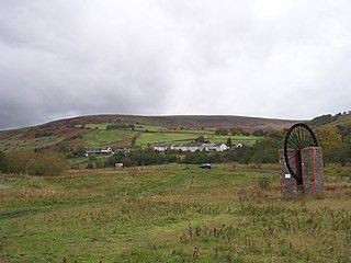
Blaencwm is a village in the county borough of Rhondda Cynon Taf, Wales, lying at the head the Rhondda Fawr valley. Two collieries were opened here during the Industrial Revolution, the Dunraven Colliery in 1865 and the Glenrhondda Colliery in 1911. Both had closed by 1966 and the sites have since been landscaped, leaving little trace of their industrial past. It is in the historic county of Glamorgan.
Nantgarw Colliery was a coal mine and later developed Coking coal works, located in the village on Nantgarw, Mid Glamorgan, Wales located just north of Cardiff.
Tynewydd is a village located in the County Borough of Rhondda Cynon Taf, south Wales. With Treherbert, Blaencwm, Blaenrhondda and Pen-yr-englyn it is part of a community of Treherbert. The village lies in the former industrial coal mining area at the head of Rhondda Fawr, the larger of the Rhondda Valleys.
Maerdy Colliery was a coal mine located in the South Wales village of Maerdy, in the Rhondda Valley, located in the county borough of Rhondda Cynon Taf, and within the historic county boundaries of Glamorgan, Wales. Opened in 1875, it closed in December 1990.
Ferndale Colliery was a series of nine coal mines, located close to the village of Ferndale, Rhondda Cynon Taf in the Rhondda Valley, South Wales.
Bwllfa Colliery was a coal mine, located in the Dare valley near Cwmdare in Rhondda Cynon Taf, South Wales. It operated from 1856 to 1957, remaining open as a ventilation shaft for Mardy Colliery until 1977.
Cwm Clydach is a community and electoral ward to the northwest of Tonypandy in Rhondda Cynon Taf, Wales. The community and ward covers the valley of the Nant Clydach, which includes the cojoined villages of Clydach Vale and Blaenclydach.