Butler Bay, United States Virgin Islands | |
|---|---|
Village | |
| Country | |
| Island | Saint Croix |
| Time zone | UTC-4 (AST) |
Butler Bay is a settlement on the island of Saint Croix in the United States Virgin Islands.
Butler Bay, United States Virgin Islands | |
|---|---|
Village | |
| Country | |
| Island | Saint Croix |
| Time zone | UTC-4 (AST) |
Butler Bay is a settlement on the island of Saint Croix in the United States Virgin Islands.

The United States Virgin Islands are a group of several dozen islands and cays located in the Caribbean, about 1,100 miles (1,770 km) southeast of Florida, 600 miles (966 km) north of Venezuela, 40 miles (64 km) east of Puerto Rico, and immediately west and south of the British Virgin Islands.

The House of the Vestal Virgins was the residence of Vestal Virgins, located behind the circular Temple of Vesta at the eastern edge of the Roman Forum, between the Regia and the Palatine Hill. The domus publica, where the Pontifex Maximus dwelled, was located near the Atrium until that role was assumed by the emperors.

Cruz Bay, U.S. Virgin Islands is the main town on the island of Saint John in the United States Virgin Islands. According to the 2000 census, Cruz Bay had a population of 2,743.

Trunk Bay is a body of water and a beach on St. John in the United States Virgin Islands. Trunk Bay is part of the Virgin Islands National Park. Trunk Bay is named for the Leatherback turtle, which is endemic to the U.S.V.I. and is locally known as trunks. The beach area is divided into two halves, the main Trunk Bay beach and swim area and Burgesman Cove which is located on the west end of Trunk Bay near Jumby Bay. Its amenities include a snack bar, showers and restrooms, a lifeguard, and an underwater trail for snorkeling its coral reef. Trunk Bay has consistently been voted one of the top beaches in the world.
Spipiyus Provincial Park is a 2,979 hectare provincial park in British Columbia, Canada. Also known as the Caren Range, Spipiyus Park is north of Halfmoon Bay on the Sechelt Peninsula. It protects pockets of old-growth forest, prime habitat for the marbled murrelet. There are hiking trails that lead to Mount Hallowell with views of the islands and fjords of Pender Harbour, the Strait of Georgia and Vancouver Island.

The Tiburon Peninsula is a landform of the San Francisco Bay Area's Marin County and is home to the incorporated municipalities of Tiburon, Belvedere, and a portion of Corte Madera, California. Much of the peninsula is unincorporated, including portions of the north side and the communities of Paradise Cay and Strawberry. Richardson Bay separates the peninsula from the Marin County mainland. Angel Island lies app. 1 mile south of the peninsula's southern tip. Much of the land area of the Tiburon Peninsula was part of a Spanish land grant originally given to the early Californian John Reed. A prominent feature of the Tiburon Peninsula is Ring Mountain, Marin County, which forms the backbone of the peninsula and is the highest elevation of the peninsula. The Tiburon Peninsula is the location of a number of rare and endangered flora species, and is also the site of ancient Native American rock carvings. The mineral lawsonite was first described from an occurrence on the Tiburon Peninsula.

Confusion Bay is a natural bay located on the north-east tip of the Baie Verte Peninsula of the island of Newfoundland, in the Canadian province of Newfoundland and Labrador.
Carolina is a neighborhood on the island of Saint John in the United States Virgin Islands. It is located in the hills to the west of Coral Bay.
Fish Bay is a bay and neighborhood on the island of Saint John in the United States Virgin Islands. Most of this area is part of Virgin Islands National Park.
Hermitage is an area of Virgin Islands National Park on the island of Saint John in the United States Virgin Islands. It is located along the north side of Coral Bay, between the town of Coral Bay and the island's inhabited East End. The mangroves of Princess Bay, inside the National Park, are a popular kayaking and snorkeling spot.
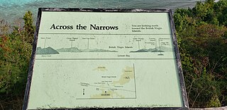
Leinster Bay is a bay and former sugar cane plantation on the island of Saint John in the United States Virgin Islands. It is uninhabited and part of Virgin Islands National Park. Visitors can park at Annaberg and hike the Leinster Bay trail to access the bay, which is a popular snorkeling spot. Waterlemon Cay is a small cay in Leinster Bay. The ruins of the plantation's estate house can be reached by continuing past the bay and up the Johnny Horn Trail.
Hams Bay is a settlement on the island of Saint Croix in the United States Virgin Islands.
Negro Bay is a settlement on the island of Saint Croix in the United States Virgin Islands.
Ruan Bay is a settlement on the island of Saint Croix in the United States Virgin Islands.
Sunny Isle is a shopping center at Sion Farm on the island of Saint Croix in the United States Virgin Islands.
Teagues Bay is a settlement on the island of Saint Croix in the United States Virgin Islands.
Whites Bay is a settlement on the island of Saint Croix in the United States Virgin Islands.
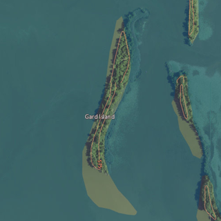
Gard Island is an island in Maumee Bay, in Monroe County, Michigan. Its coordinates are 41°44′55″N83°26′37″W, and the United States Geological Survey gave its elevation as 568 ft (173 m) in 1980. It was labeled "Guard Island", along with Indian Island and Squaw Island, on a 1900 USGS map of the area. A 1938 map showed it alongside Indian Island, Odeen Island, and Woodtick Island.
Coordinates: 17°44′55″N64°53′30″W / 17.74861°N 64.89167°W
| | This Saint Croix, United States Virgin Islands location article is a stub. You can help Wikipedia by expanding it. |