
Barnstable County is a county located in the U.S. state of Massachusetts. At the 2020 census, the population was 228,996. Its county seat is Barnstable. The county consists of Cape Cod and associated islands.
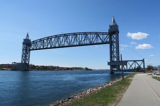
Buzzards Bay is a census-designated place (CDP) in the town of Bourne in Barnstable County, Massachusetts, United States. The population was 3,859 at the 2010 census. It is the most populous of the five CDPs in Bourne.

Freetown is a town in Bristol County, Massachusetts, United States. The population was 9,206 at the 2020 census.
Swansea is a town in Bristol County in southeastern Massachusetts, United States. It is located at the mouth of the Taunton River, just west of Fall River, 47 miles (76 km) south of Boston, and 12 miles (19 km) southeast of Providence, Rhode Island. The population was 17,144 at the 2020 census. The villages of Hortonville, Barneyville and Ocean Grove are located in the town.

Carver is a town in Plymouth County, Massachusetts, United States. The population was 11,645 at the 2020 census. It is named for John Carver, the first governor of the Plymouth Colony. The town features two popular tourist attractions: Edaville USA theme park and King Richard's Faire, the largest and longest-running renaissance fair in New England.
Halifax is a town in Plymouth County, Massachusetts, United States. The population was 7,749 at the 2020 census.

Marion is a town in Plymouth County, Massachusetts, United States. The population was 5,347 at the 2020 census.

Mattapoisett is a town in Plymouth County, Massachusetts, United States. The population was 6,508 at the 2020 census. Mattapoisett Center is located in the town.

Wareham is a town in Plymouth County, Massachusetts, United States. As of the 2022 census, the town had a population of 23,303.

Hull is a town in Plymouth County, Massachusetts, United States, located on a peninsula at the southern edge of Boston Harbor. Its population was 10,072 at the 2020 census. Hull is the smallest town by land area in Plymouth County and the eleventh smallest in the state. However, its population density is nearly four times that of Massachusetts as a whole.

Bourne is a town in Barnstable County, Massachusetts, United States. The population was 20,452 at the 2020 census.
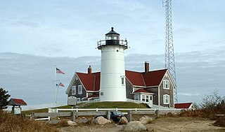
Falmouth is a town in Barnstable County, Massachusetts, United States. The population was 32,517 at the 2020 census, making Falmouth the second-largest municipality on Cape Cod after Barnstable. The terminal for the Steamship Authority ferries to Martha's Vineyard is located in the village of Woods Hole in Falmouth. Woods Hole also contains several scientific organizations such as the Woods Hole Oceanographic Institution (WHOI), the Marine Biological Laboratory (MBL), the Woodwell Climate Research Center, NOAA's Woods Hole Science Aquarium, and the scientific institutions' various museums.

Marshfield is a town in Plymouth County, Massachusetts, United States, on Massachusetts's South Shore. The population was 25,825 at the 2020 census.

Plymouth is a town and county seat of Plymouth County, Massachusetts, United States. Located in Greater Boston, the town holds a place of great prominence in American history, folklore, and culture, and is known as "America's Hometown". Plymouth was the site of the colony founded in 1620 by the Mayflower Pilgrims, where New England was first established. It is the oldest municipality in New England and one of the oldest in the United States. The town has served as the location of several prominent events, one of the more notable being the First Thanksgiving feast. Plymouth served as the capital of Plymouth Colony from its founding in 1620 until the colony's merger with the Massachusetts Bay Colony in 1691. The English explorer John Smith named the area Plymouth and the region 'New England' during his voyage of 1614. It was a later coincidence that, after an aborted attempt to make the 1620 trans-Atlantic crossing from Southampton, the Mayflower finally set sail for America from Plymouth, England.

Padanaram is a coastal village in South Dartmouth, Massachusetts, United States. The village is located on Buzzards Bay, more specifically near the inlet of Apponagansett Bay.
West Wind Shores is a small village in Plymouth, Massachusetts, United States. It is located south of Long Pond and north of Buzzards Bay, Whites Pond, Little Sandy Pond, Big Sandy Pond, and Ezekiel Pond. The village is built around several small ponds.

Plymouth North High School, formerly known as Plymouth-Carver Regional High School, and known informally as Plymouth North or PNHS, is a public high school located in Plymouth, Massachusetts, United States. Its students are residents of the town of Plymouth. The school is one of two high schools in Plymouth, the other being Plymouth South High School. Plymouth North is located south of Plymouth Center, and is located adjacent to the Plymouth County Courthouse, the Plymouth County Registry of Deeds, and Beth Israel Deaconess Hospital. The school colors are Blue, White & Silver and the school mascot is an Eagle. Plymouth North opened under the name Plymouth High School, but changed its name to Plymouth-Carver Regional High School when Carver joined the district in 1963. With the opening of Carver High School in 1987, it was renamed Plymouth North High School. It serves over 1300 students in grades 9-12 from the North, West, and Central neighborhoods of Plymouth. Plymouth North features a full range of academic courses as well as state-of-the-art vocational technical programs in Marketing, Allied Health, Engineering, and Facilities Management. Plymouth North High School is accredited by the New England Association of Schools and Colleges. In June 2021, Plymouth North High School was placed into a state program for schools or districts that disproportionately suspend nonwhite students or students with disabilities.
Plymouth South High School, also known as Plymouth South, or PSHS, is a public high school located in Plymouth, Massachusetts, United States. Its students are residents of the town of Plymouth. Plymouth South is one of two high schools in Plymouth, the other being Plymouth North High School.
Plymouth Public Schools is a school district that serves Plymouth, Massachusetts. It operates 12 schools, making it one of the largest town school districts in the state. In June 2021, the Plymouth Public Schools were placed into a state program for schools or districts that disproportionately suspend nonwhite students or students with disabilities.

Barnstable is a town in the U.S. state of Massachusetts and the county seat of Barnstable County. Barnstable is the largest community, both in land area and population, on Cape Cod, and is one of thirteen Massachusetts municipalities that have been granted city forms of government by the Commonwealth of Massachusetts but wish to retain "the town of" in their official names. At the 2020 census it had a population of 48,916. The town contains several villages within its boundaries. Its largest village, Hyannis, is the central business district of the county and home to Barnstable Municipal Airport, the airline hub of Cape Cod and the islands of Martha's Vineyard and Nantucket. Additionally, Barnstable is a 2007 winner of the All-America City Award.