North Plymouth, Massachusetts

Last updated

North Plymouth, Massachusetts
Cordage Commerce Center.JPG
Factory of the Plymouth Cordage Company, now the Cordage Park commercial complex
Plymouth County Massachusetts incorporated and unincorporated areas North Plymouth highlighted.svg
Location in Plymouth County in Massachusetts
Coordinates: 41°58′17″N70°41′13″W / 41.97139°N 70.68694°W / 41.97139; -70.68694
Country United States
State Massachusetts
County Plymouth
Town Plymouth
Area
[1]
  Total3.47 sq mi (9.00 km2)
  Land1.25 sq mi (3.23 km2)
  Water2.23 sq mi (5.77 km2)
Elevation
82 ft (25 m)
Population
 (2020)
  Total3,983
  Density3,196.63/sq mi (1,234.24/km2)
Time zone UTC-5 (Eastern (EST))
  Summer (DST) UTC-4 (EDT)
ZIP code
02362 (P.O. box holders only)
02360
Area code 508/774
FIPS code 25-48780
GNIS feature ID0615267

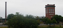
North Plymouth is a census-designated place (CDP) in the town of Plymouth in Plymouth County, Massachusetts, United States. The population was 3,600 at the 2010 census. [2] it is best known as the location of Cordage Park, a small village where the Plymouth Cordage Company was once headquartered. The village is now home to Cordage Commerce Center, a large retail development that consists of offices and stores.

Contents

Geography

North Plymouth is located at 41°58′17″N70°41′13″W / 41.97139°N 70.68694°W / 41.97139; -70.68694 (41.971285, -70.686980). [3]

According to the United States Census Bureau, the CDP has a total area of 9.1 km2 (3.5 mi2), of which 3.3 km2 (1.3 mi2) is land and 5.8 km2 (2.2 mi2) (63.71%) is water.

Demographics

Historical population
CensusPop.Note
2020 3,983
U.S. Decennial Census [4]
The Plymouth MBTA station in North Plymouth Plymouth station facing inbound 1.jpg
The Plymouth MBTA station in North Plymouth

As of the census [5] of 2000, there were 3,593 people, 1,506 households, and 884 families residing in the CDP. The population density was 1,092.3/km2 (2,832.7/mi2). There were 1,580 housing units at an average density of 480.3/km2 (1,245.7/mi2). The racial makeup of the CDP was 93.46% White, 1.95% African American, 0.28% Native American, 0.58% Asian, 1.03% from other races, and 2.70% from two or more races. Hispanic or Latino of any race were 1.00% of the population.

There were 1,506 households, out of which 28.8% had children under the age of 18 living with them, 38.2% were married couples living together, 16.3% had a female householder with no husband present, and 41.3% were non-families. 33.7% of all households were made up of individuals, and 18.2% had someone living alone who was 65 years of age or older. The average household size was 2.36 and the average family size was 3.05.

In the CDP, the population was spread out, with 24.5% under the age of 18, 7.6% from 18 to 24, 30.8% from 25 to 44, 19.4% from 45 to 64, and 17.7% who were 65 years of age or older. The median age was 37 years. For every 100 females, there were 87.3 males. For every 100 females age 18 and over, there were 82.6 males.

The median income for a household in the CDP was $35,561, and the median income for a family was $38,380. Males had a median income of $35,372 versus $26,920 for females. The per capita income for the CDP was $17,508. About 11.2% of families and 14.4% of the population were below the poverty line, including 19.3% of those under age 18 and 15.5% of those age 65 or over.

See also

Related Research Articles

<span class="mw-page-title-main">Marion Center, Massachusetts</span> Census-designated place in Massachusetts, United States

Marion Center is a census-designated place (CDP) in the town of Marion in Plymouth County, Massachusetts, United States. The population was 1,111 at the 2010 census.

<span class="mw-page-title-main">Marshfield Hills, Massachusetts</span> Census-designated place in Massachusetts, United States

Marshfield Hills is a census-designated place (CDP) in the town of Marshfield in Plymouth County, Massachusetts, United States. The population was 2,356 at the 2010 census. The historic center of the village has been designated a historic district and listed on the National Register of Historic Places.

<span class="mw-page-title-main">Mattapoisett Center, Massachusetts</span> Census-designated place in Massachusetts, United States

Mattapoisett Center is a census-designated place (CDP) in the town of Mattapoisett in Plymouth County, Massachusetts. The population was 2,915 at the 2010 census.

<span class="mw-page-title-main">Middleborough Center, Massachusetts</span> Census-designated place in Massachusetts, United States

Middleborough Center is a census-designated place (CDP) in the town of Middleborough in Plymouth County, Massachusetts, United States. The population was 7,319 at the 2010 census.

<span class="mw-page-title-main">North Lakeville, Massachusetts</span> Census-designated place in Massachusetts, United States

North Lakeville is a census-designated place (CDP) in the town of Lakeville in Plymouth County, Massachusetts, United States. The population was 2,630 at the 2010 census.

<span class="mw-page-title-main">North Pembroke, Massachusetts</span> Census-designated place in Massachusetts, United States

North Pembroke is a census-designated place (CDP) in the town of Pembroke in Plymouth County, Massachusetts, United States. The population was 3,292 at the 2010 census.

<span class="mw-page-title-main">North Scituate, Massachusetts</span> Census-designated place in Massachusetts, United States

North Scituate is a census-designated place (CDP) in the town of Scituate in Plymouth County, Massachusetts, United States. The population was 5,077 at the 2010 census. It was formerly known as Gannet Corner.

<span class="mw-page-title-main">South Duxbury, Massachusetts</span> Census-designated place in Massachusetts, United States

South Duxbury is a census-designated place (CDP) in the town of Duxbury in Plymouth County, Massachusetts, United States. The population was 3,360 at the 2010 census.

<span class="mw-page-title-main">Wareham Center, Massachusetts</span> Census-designated place in Massachusetts, United States

Wareham Center is a census-designated place (CDP) in the town of Wareham in Plymouth County, Massachusetts, United States. The population was 2,896 at the 2010 census.

<span class="mw-page-title-main">West Wareham, Massachusetts</span> Census-designated place in Massachusetts, United States

West Wareham is a census-designated place (CDP) in the town of Wareham in Plymouth County, Massachusetts, United States. The population was 2,064 at the 2010 census.

<span class="mw-page-title-main">Weweantic, Massachusetts</span> Census-designated place in Massachusetts, United States

Weweantic is a census-designated place (CDP) in the town of Wareham in Plymouth County, Massachusetts, United States. The population was 2,105 at the 2010 census.

<span class="mw-page-title-main">White Island Shores, Massachusetts</span> Census-designated place in Massachusetts, United States

White Island Shores is a census-designated place (CDP) in the town of Wareham in Plymouth County, Massachusetts, United States, along the shores of White Island Pond. The population was 2,106 at the 2010 census.

<span class="mw-page-title-main">Bridgewater (CDP), Massachusetts</span> Census-designated place in Massachusetts, United States

Bridgewater was a census-designated place (CDP) in the town of Bridgewater in Plymouth County, Massachusetts, United States. The CDP ceased to exist when Bridgewater was given de facto city status in 2010. The population was 7,841 at the 2010 census.

<span class="mw-page-title-main">Duxbury (CDP), Massachusetts</span> Census-designated place in Massachusetts, United States

Duxbury is a census-designated place (CDP) in the town of Duxbury in Plymouth County, Massachusetts, United States. The population was 1,802 at the 2010 census.

<span class="mw-page-title-main">Hingham (CDP), Massachusetts</span> Census-designated place in Massachusetts, United States

Hingham is a census-designated place (CDP) in the town of Hingham in Plymouth County, Massachusetts, United States. The population was 5,650 at the 2010 census.

<span class="mw-page-title-main">Kingston (CDP), Massachusetts</span> Census-designated place in Massachusetts, United States

Kingston is a census-designated place (CDP) in the town of Kingston in Plymouth County, Massachusetts, United States. The population was 5,591 at the 2010 census.

<span class="mw-page-title-main">Marshfield (CDP), Massachusetts</span> Census-designated place in Massachusetts, United States

Marshfield is a census-designated place (CDP) in the town of Marshfield in Plymouth County, Massachusetts, United States. The population was 4,335 at the 2010 census.

<span class="mw-page-title-main">Plymouth Center, Massachusetts</span> Census-designated place in Massachusetts, United States

Plymouth is a census-designated place (CDP) in the town of Plymouth in Plymouth County, Massachusetts, United States. It is often referred to as Downtown Plymouth or Plymouth Center. The population was 7,494 at the 2010 census.

<span class="mw-page-title-main">Scituate (CDP), Massachusetts</span> Census-designated place in Massachusetts, United States

Scituate is a census-designated place (CDP) in the town of Scituate in Plymouth County, Massachusetts, United States. The population was 5,245 at the 2010 census.

Fryeburg is a census-designated place (CDP) in the town of Fryeburg in Oxford County, Maine, United States. The population was 1,444 at the 2020 census.

References

  1. "2020 U.S. Gazetteer Files". United States Census Bureau. Retrieved May 21, 2022.
  2. "Profile of General Population and Housing Characteristics: 2010 Demographic Profile Data (DP-1): North Plymouth CDP, Massachusetts". United States Census Bureau . Retrieved March 26, 2012.
  3. "US Gazetteer files: 2010, 2000, and 1990". United States Census Bureau. February 12, 2011. Retrieved April 23, 2011.
  4. "Census of Population and Housing". Census.gov. Retrieved June 4, 2016.
  5. "U.S. Census website". United States Census Bureau . Retrieved January 31, 2008.