North Scituate, Massachusetts

Last updated

North Scituate, Massachusetts
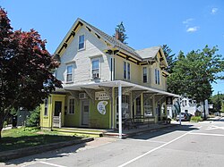
Baked, North Scituate MA.jpg
A kitchen store in North Scituate
Plymouth County Massachusetts incorporated and unincorporated areas North Scituate highlighted.svg
Location in Plymouth County in Massachusetts
Coordinates: 42°12′44″N70°45′59″W / 42.21222°N 70.76639°W / 42.21222; -70.76639
Country United States
State Massachusetts
County Plymouth
Area
[1]
  Total3.81 sq mi (9.86 km2)
  Land3.75 sq mi (9.71 km2)
  Water0.06 sq mi (0.15 km2)
Elevation
13 ft (4 m)
Population
 (2020)
  Total5,414
  Density1,443.35/sq mi (557.31/km2)
Time zone UTC-5 (Eastern (EST))
  Summer (DST) UTC-4 (EDT)
ZIP code
02060
Area code 781
FIPS code 25-49165
GNIS feature ID0613848

North Scituate is a census-designated place (CDP) in the town of Scituate in Plymouth County, Massachusetts, United States. The population was 5,077 at the 2010 census. [2] It was formerly known as Gannet Corner. [3]

Contents

Geography

North Scituate is located at 42°12′44″N70°45′59″W / 42.21222°N 70.76639°W / 42.21222; -70.76639 (42.212308, −70.766478). [4]

According to the United States Census Bureau, the CDP has a total area of 10.1 km2 (3.9 mi2), of which 10.0 km2 (3.9 mi2) is land and 0.1 km2 (0.1 mi2) (1.28%) is water.

The word "Scituate" is derived from the Native American word satuit, meaning "cold brook", referring to the river that runs into Scituate Harbor.

North Scituate has one freshwater pond, Hunter's Pond, which is fed by Bound Brook. Hunter's Pond flows into the saltwater Gulph River via a waterfall at Mordecai Lincoln Road.

Direct train service from North Scituate into Boston is available from North Scituate station on the Greenbush Line of MBTA Commuter Rail.

Demographics

Historical population
CensusPop.Note
2020 5,414
U.S. Decennial Census [5]

As of the census [6] of 2000, there were 5,065 people, 1,849 households, and 1,432 families residing in the CDP. The population density was 505.3/km2 (1,310.4/mi2). There were 1,901 housing units at an average density of 189.7/km2 (491.8/mi2). The racial makeup of the CDP was 97.81% White, 0.22% African American, 0.04% Native American, 0.41% Asian, 0.04% Pacific Islander, 0.93% from other races, and 0.55% from two or more races. Hispanic or Latino of any race were 0.95% of the population.

There were 1,849 households, out of which 36.7% had children under the age of 18 living with them, 67.8% were married couples living together, 7.8% had a female householder with no husband present, and 22.5% were non-families. 19.9% of all households were made up of individuals, and 10.5% had someone living alone who was 65 years of age or older. The average household size was 2.74 and the average family size was 3.18.

In the CDP, the population was spread out, with 27.5% under the age of 18, 4.0% from 18 to 24, 27.0% from 25 to 44, 25.8% from 45 to 64, and 15.7% who were 65 years of age or older. The median age was 40 years. For every 100 females, there were 94.1 males. For every 100 females age 18 and over, there were 87.8 males.

The median income for a household in the CDP was $79,556, and the median income for a family was $92,074. (These figures had risen to $90,082 and $116,263 respectively as of a 2010 estimate). Males had a median income of $65,385 versus $43,839 for females. The per capita income for the CDP was $32,098. About 1.4% of families and 2.3% of the population were below the poverty line, including 0.8% of those under age 18 and 6.8% of those age 65 or over.

Related Research Articles

<span class="mw-page-title-main">Broadview-Pompano Park</span> Neighborhood in Broward, Florida, United States

Broadview-Pompano Park is a neighborhood and former census-designated place (CDP) in North Lauderdale, Broward County, Florida, United States. The population was 5,314 at the 2000 census.

<span class="mw-page-title-main">Burnt Store Marina, Florida</span> Census-designated place in Florida, United States

Burnt Store Marina is an unincorporated community and census-designated place (CDP) in Lee County, Florida, United States. The population was 1,890 at the 2020 census, up from 1,793 at the 2010 census. It is part of the Cape Coral-Fort Myers, Florida Metropolitan Statistical Area.

<span class="mw-page-title-main">Paukaa, Hawaii</span> Census-designated place in Hawaii, U.S.

Paukaʻa is a census-designated place (CDP) in Hawaii County, Hawaii, United States. The population was 425 at the 2010 census, down from 495 at the 2000 census. The ZIP code is 96720.

<span class="mw-page-title-main">East Falmouth, Massachusetts</span> Census-designated place in Massachusetts, United States

East Falmouth is a census-designated place (CDP) in the town of Falmouth in Barnstable County, Massachusetts, United States. It is located at the base of Massachusetts' "fishhook" peninsula. The population was 6,038 at the 2010 census, making East Falmouth the most populous of the six CDPs in Falmouth.

<span class="mw-page-title-main">East Harwich, Massachusetts</span> Census-designated place in Massachusetts, United States

East Harwich is a census-designated place (CDP) and village in the town of Harwich in Barnstable County, Massachusetts, United States. The population was 4,872 at the 2010 census.

<span class="mw-page-title-main">Monomoscoy Island, Massachusetts</span> Census-designated place in Massachusetts, United States

Monomoscoy Island is a census-designated place (CDP) in the town of Mashpee in Barnstable County, Massachusetts, United States. At the 2010 census, the CDP had a total population of 147.

<span class="mw-page-title-main">West Yarmouth, Massachusetts</span> Census-designated place in Massachusetts, United States

West Yarmouth is a census-designated place (CDP) in the town of Yarmouth in Barnstable County, Massachusetts, United States. The population was 6,012 at the 2010 census.

<span class="mw-page-title-main">Cochituate, Massachusetts</span> Census-designated place in Massachusetts, United States

Cochituate is a census-designated place (CDP) in the town of Wayland in Middlesex County, Massachusetts, United States. The population was 6,927 at the 2020 census, out of 13,943 in the entire town of Wayland.

<span class="mw-page-title-main">Littleton Common, Massachusetts</span> Census-designated place in Massachusetts, United States

Littleton Common is a census-designated place (CDP) in the town of Littleton in Middlesex County, Massachusetts, United States. The population was 3,065 at the 2020 census, up from 2,789 in 2010.

<span class="mw-page-title-main">West Concord, Massachusetts</span> Census-designated place in Massachusetts, United States

West Concord is an unincorporated village and census-designated place (CDP) in the town of Concord in Middlesex County, Massachusetts, United States. The population was 6,320 at the 2020 census.

<span class="mw-page-title-main">Green Harbor-Cedar Crest, Massachusetts</span> Former census-designated place in Massachusetts, United States

Green Harbor-Cedar Crest was a census-designated place (CDP) in the towns of Duxbury and Marshfield in Plymouth County, United States. It included the village of Green Harbor, on the shore of Massachusetts Bay, and the community of Cedar Crest, occupying a hill on the north side of Careswell Street. The population of the CDP was 2,609 at the 2010 census. Prior to the 2020 census the area was split into two CDPs, Green Harbor and Cedar Crest.

<span class="mw-page-title-main">North Lakeville, Massachusetts</span> Census-designated place in Massachusetts, United States

North Lakeville is a census-designated place (CDP) in the town of Lakeville in Plymouth County, Massachusetts, United States. The population was 2,630 at the 2010 census.

<span class="mw-page-title-main">North Pembroke, Massachusetts</span> Census-designated place in Massachusetts, United States

North Pembroke is a census-designated place (CDP) in the town of Pembroke in Plymouth County, Massachusetts, United States. The population was 3,292 at the 2010 census.

<span class="mw-page-title-main">Salem, New Mexico</span> CDP in New Mexico, United States

Salem is a census-designated place (CDP) in Doña Ana County, New Mexico, United States. The population was 942 at the 2010 census. It is part of the Las Cruces Metropolitan Statistical Area.

<span class="mw-page-title-main">Harris Township, Centre County, Pennsylvania</span> Township in Pennsylvania, United States

Harris Township is a township in Centre County, Pennsylvania, United States. It is part of the State College, Pennsylvania Metropolitan Statistical Area. Boalsburg, a census-designated place (CDP), is located within the township. The population was 4,873 at the 2010 census, which is a 4.6% increase since the 2000 census.

<span class="mw-page-title-main">Ayer (CDP), Massachusetts</span> Census-designated place in Massachusetts, United States

Ayer is a census-designated place (CDP) and the primary settlement in the town of Ayer in Middlesex County, Massachusetts, United States. The population of the CDP was 2,986 at the 2020 census, out of 8,479 in the entire town.

<span class="mw-page-title-main">Duxbury (CDP), Massachusetts</span> Census-designated place in Massachusetts, United States

Duxbury is a census-designated place (CDP) in the town of Duxbury in Plymouth County, Massachusetts, United States. The population was 1,802 at the 2010 census.

<span class="mw-page-title-main">Marshfield (CDP), Massachusetts</span> Census-designated place in Massachusetts, United States

Marshfield is a census-designated place (CDP) in the town of Marshfield in Plymouth County, Massachusetts, United States. The population was 4,335 at the 2010 census.

<span class="mw-page-title-main">Plymouth Center, Massachusetts</span> Census-designated place in Massachusetts, United States

Plymouth is a census-designated place (CDP) in the town of Plymouth in Plymouth County, Massachusetts, United States. It is often referred to as Downtown Plymouth or Plymouth Center. The population was 7,494 at the 2010 census.

<span class="mw-page-title-main">Scituate (CDP), Massachusetts</span> Census-designated place in Massachusetts, United States

Scituate is a census-designated place (CDP) in the town of Scituate in Plymouth County, Massachusetts, United States. The population was 5,245 at the 2010 census.

References

  1. "2020 U.S. Gazetteer Files". United States Census Bureau. Retrieved May 21, 2022.
  2. "Profile of General Population and Housing Characteristics: 2010 Demographic Profile Data (DP-1): North Scituate CDP, Massachusetts". United States Census Bureau . Retrieved March 26, 2012.
  3. CIS: Unincorporated and Unofficial Names of Massachusetts Communities
  4. "US Gazetteer files: 2010, 2000, and 1990". United States Census Bureau. February 12, 2011. Retrieved April 23, 2011.
  5. "Census of Population and Housing". Census.gov. Retrieved June 4, 2016.
  6. "U.S. Census website". United States Census Bureau . Retrieved January 31, 2008.