Buulo Togoro | |
|---|---|
Town | |
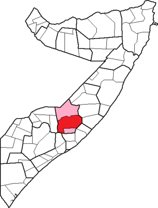
 Buulo Togoro Location in Somalia. | |
| Coordinates: 3°31′N45°32′E / 3.517°N 45.533°E | |
| Country | |
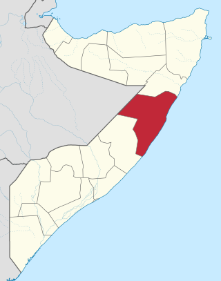
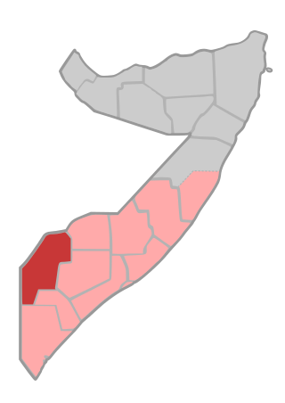
| Region | Hiran |
| Time zone | UTC+3 (EAT) |
Buulo Togoro is a town in the central Hiran region of Somalia. [1]
Buulo Togoro | |
|---|---|
Town | |
| Buulo Togoro Location in Somalia. | |
| Coordinates: 3°31′N45°32′E / 3.517°N 45.533°E | |
| Country | |
| Region | Hiran |
| Time zone | UTC+3 (EAT) |
Buulo Togoro is a town in the central Hiran region of Somalia. [1]

Somalia, officially the Federal Republic of Somalia, is a country in the Horn of Africa. The country is bordered by Ethiopia to the west, Djibouti to the northwest, the Gulf of Aden to the north, the Indian Ocean to the east, and Kenya to the southwest. Somalia has the longest coastline on Africa's mainland. Its terrain consists mainly of plateaus, plains, and highlands. Hot conditions prevail year-round, with periodic monsoon winds and irregular rainfall. Somalia has an estimated population of around 17.1 million, of which over 2 million live in the capital and largest city Mogadishu, and has been described as Africa's most culturally homogeneous country. Around 85% of its residents are ethnic Somalis, who have historically inhabited the country's north. Ethnic minorities are largely concentrated in the south. The official languages of Somalia are Somali and Arabic. Most people in the country are Muslims, the majority of them Sunni.
Mudug is an administrative region (gobol) in north-central Somalia. The population of Mudug is 131,455 as of 2005.

Lower Shabelle is an administrative region (gobol) in southern Somalia.
Gedo is an administrative region (gobol) in Jubaland, southern Somalia. Its regional capital is Garbahaarreey. It was created in 1974 and is bordered by the Ogaden in Ethiopia, the North Eastern Province in Kenya, and the Somali regions of Bakool, Bay, Jubbada Dhexe, and Jubbada Hoose further down east. The southern parts of Gedo, west of the Jubba River, used to be part of the old British Trans-Juba region during half of the seventy years of colonial era in Africa from 1890 to 1960. The British and Italians fought twice over this area. The first democratically elected governor of the administrative region was Hussein Farey, who entered office in 2008.
The Battle of Baidoa began on 20 December 2006 when the Somali transitional federal government forces (TFG) allied with Ethiopian forces stationed there attacked advancing Islamic Courts Union (ICU) forces along with 500 alleged Eritrean troops and mujahideen arrayed against them.
The timeline of events in the War in Somalia during 2006 is set out below.

Ténenkou Cercle is an administrative subdivision of the Mopti Region of Mali. Its seat is the town of Ténenkou, which is also its largest town. The cercle is divided into communes.
Togoro Kotia is a commune of the Cercle of Ténenkou in the Mopti Region of Mali. The principal village lies at Sossobé. The commune contains 13 villages and in 2009 had a population of 13,687.
Sossobé is a village and seat of the commune of Togoro Kotia in the Cercle of Ténenkou in the Mopti Region of southern-central Mali. The village lies in the Inner Niger Delta and between July and December is only accessible by boat.
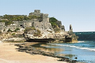
Gendershe, also known as Gandershe or El Torre, is an ancient landmark on the Somali Sea, as well as a town, in the Lower Shabelle region of present day Somalia. It is noted for its various historical structures.
Bondhere District is an ancient district in the districts of Banadir region in Somalia. This district is crossed by the following roads: General Daoud road that passes through Bondhere from Wardhiigley District. Upper Jubadan Road that passes through Shibis District. Ummada Road or as it is called "Wadnaha" which passes through Yaqshid District. Lower Juba road that passes through Shingani District. Nasib Bundo Road which divides Bondhere District and Shabelle Road which borders Bondhere and Hamarweyne Districts.
Buloburde District is a district in the central Hiran region of Somalia. Its capital lies at Buloburde.
Burane is a town in the southeastern Shabeellaha Dhexe province of Somalia. It is located in the Jowhar District.
Mubaarak is a town under the Governorate of Merca City Mainland. The Shebelle River flows through the east of Mubaarak. The Shabelle River flows south, and originates from the Ethiopian Highlands.
The Tunni are a Somali clan that make up part of the wider Digil-Rahanweyn branch. It is one of the major clans that inhabit in the South West State of Somalia and can also be found in Jubbaland.
Gaameedle are a Somali clan mainly from the southern coastal cities of; Marka and Mogadishu.
The Tunni Sultanate was a Somali Muslim Sultanate located in southwestern Somalia, south of the Shabelle river. It was ruled by the Tunni people, who spoke the Af-Tunni. The historical Tunni area corresponds to the modern-day Lower Shabelle region.
The African Union Transition Mission in Somalia (ATMIS) is an active African Union transition and drawdown mission from peacekeeping operations in Somalia. Formerly the African Union Mission to Somalia, ATMIS's mandate will end in 2024, with full transition of security operations to the Somali National Armed Forces. ATMIS consists of troops from the East African nations of Burundi, Djibouti, Ethiopia, Kenya, and Uganda.
This is a 2023 timeline of events in the Somali Civil War (2009–present).
| | This Somalia location article is a stub. You can help Wikipedia by expanding it. |