Byberry Creek

Last updated

Byberry Creek is a 6.0-mile-long (9.7 km) [1] tributary of Poquessing Creek in northeastern Philadelphia, Pennsylvania in the United States.

Tributary stream or river that flows into a main stem river or lake

A tributary or affluent is a stream or river that flows into a larger stream or main stem river or a lake. A tributary does not flow directly into a sea or ocean. Tributaries and the main stem river drain the surrounding drainage basin of its surface water and groundwater, leading the water out into an ocean.

Poquessing Creek is a 10.3-mile-long (16.6 km) creek, a right tributary of the Delaware River, that forms part of the boundary between Bucks County and the northeast section of Philadelphia, Pennsylvania. It has been part of the boundary between Bucks and Philadelphia counties since 1682.

Philadelphia Largest city in Pennsylvania, United States

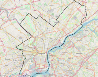
Philadelphia, sometimes known colloquially as Philly, is the largest city in the U.S. state and Commonwealth of Pennsylvania, and the sixth-most populous U.S. city, with a 2017 census-estimated population of 1,580,863. Since 1854, the city has been coterminous with Philadelphia County, the most populous county in Pennsylvania and the urban core of the eighth-largest U.S. metropolitan statistical area, with over 6 million residents as of 2017. Philadelphia is also the economic and cultural anchor of the greater Delaware Valley, located along the lower Delaware and Schuylkill Rivers, within the Northeast megalopolis. The Delaware Valley's population of 7.2 million ranks it as the eighth-largest combined statistical area in the United States.

Contents

Byberry Creek is formed from two branches that flow through Northeast Philadelphia, Wilsons Run and Waltons Run.

Northeast Philadelphia Neighborhood of Philadelphia in Philadelphia, Pennsylvania

Northeast Philadelphia, nicknamed Northeast Philly, the Northeast and the Great Northeast, is a section of the City of Philadelphia, Pennsylvania. According to the 2000 Census, the Northeast has a sizable percentage of the city's 1.547 million people—a population of between 300,000 and 450,000, depending on how the area is defined. Beginning in the 1980s, many of the Northeast's middle class children graduated from college and settled in suburbs, especially nearby Bucks County. The Northeast is home to a large working class Irish American population, but is also home to Polish, German, Jewish, Italian, Portuguese and Russian neighborhoods.

Northeast Philadelphia Airport

Northeast Philadelphia Airport is a public airport just north of the intersection of Grant Avenue and Ashton Road in Northeast Philadelphia. It is part of the Philadelphia Airport System along with Philadelphia International Airport and is the general aviation reliever airport for Philadelphia International. Northeast Philadelphia Airport is the sixth busiest airport in Pennsylvania. Two fixed-base operators provide fuel, major aircraft repair, hangar rental, aircraft rental and charter, flight instruction, and aircraft sales.

The two tributaries join to form the main channel of Byberry Creek near Academy Road adjacent to Archbishop Ryan High School as seen in aerial images of the area at coordinates 40°05′12″N74°59′04″W / 40.086609°N 74.984436°W / 40.086609; -74.984436 .

Archbishop Ryan High School

Archbishop Ryan High School is a Roman Catholic high school located in Philadelphia, Pennsylvania, USA. The school is named after Patrick John Ryan, Archbishop of Philadelphia from 1894 to 1911.

Byberry Creek joins Poquessing Creek approximately one mile before the confluence with the Delaware River.

Delaware River major river on the East coast of the United States of America

The Delaware River is a major river on the Atlantic coast of the United States. It drains an area of 14,119 square miles (36,570 km2) in five U.S. states: Delaware, Maryland, New Jersey, New York, Pennsylvania. Rising in two branches in New York state's Catskill Mountains, the river flows 419 miles (674 km) into Delaware Bay where its waters enter the Atlantic Ocean near Cape May in New Jersey and Cape Henlopen in Delaware. Not including Delaware Bay, the river's length including its two branches is 388 miles (624 km). The Delaware River is one of nineteen "Great Waters" recognized by the America's Great Waters Coalition.

See also

Related Research Articles

Little Juniata River tributary of the Juniata River in Pennsylvania, United States

The Little Juniata River, sometimes called the "Little J," is a river that is not owned by anyone person. It is held in trust by the state of Pennsylvania for the people of the state and beyond. Pennsylvania. 32.1-mile-long (51.7 km) tributary of the Juniata River in the Susquehanna River watershed. It is formed at Altoona by the confluence of several short streams. It flows northeast in the Logan Valley at the foot of Brush Mountain.

Byberry, Philadelphia Former Township in Pennsylvania, United States

Byberry is a neighborhood in the far northeast section of Philadelphia, in the U.S. state of Pennsylvania. Originally it was incorporated as the Township of Byberry and was the northeasternmost municipality of Philadelphia County before the City and County were consolidated in 1854. Its approximate boundaries are the Poquessing Creek to the north, Woodhaven Road to the south, the Roosevelt Boulevard to the west, and Thornton Road to the east.

South Branch Raritan River river in the United States of America

The South Branch Raritan River is a 50-mile-long (80 km) tributary of the Raritan River in central New Jersey in the United States.

Pennypack Creek river in the United States of America

Pennypack Creek is a 22.6-mile-long (36.4 km) creek in southeastern Pennsylvania in the United States. It runs southeast through lower Bucks County, eastern Montgomery County and the northeast section of Philadelphia, before emptying into the Delaware River.

Penns Creek tributary of the Susquehanna River in Pennsylvania

Penns Creek is a 67.1-mile-long (108.0 km) tributary of the Susquehanna River in central Pennsylvania in the United States.

Liberty Bell Park was an American race track in Northeast Philadelphia that held harness racing and Thoroughbred horse racing from 1963 until 1986. The site, northeast of the intersection of Knights and Woodhaven Roads, was derived from several farms and smaller farmettes.

Chester Creek

Chester Creek is a 9.4-mile-long (15.1 km) tributary of the Delaware River in Delaware County, Pennsylvania in the United States.

Black Moshannon Creek creek in Pennsylvania, United States

Black Moshannon Creek is a 22.9-mile-long (36.9 km) tributary of Moshannon Creek in Centre County, Pennsylvania in the United States.

Frankstown Branch Juniata River river in the United States of America

The Frankstown Branch Juniata River is a 46.0-mile-long (74.0 km) tributary of the Juniata River in Blair and Huntingdon Counties, Pennsylvania, in the United States.

Cocalico Creek river in the United States of America

Cocalico Creek is a 27.2-mile-long (43.8 km) tributary of the Conestoga River in Lebanon and Lancaster counties in Pennsylvania in the United States. The source is at an elevation of 1,320 feet (400 m) near Stricklerstown in Millcreek Township, Lebanon County. The mouth is the confluence with the Conestoga River at an elevation of 278 feet (85 m) at Talmage in West Earl Township, Lancaster County.

Codorus Creek is a 42.4-mile-long (68.2 km) tributary of the Susquehanna River in York County, Pennsylvania in the United States.

Sinking Creek is a tributary of Penns Creek in Centre County, Pennsylvania, in the United States. It is approximately 19.8 miles (31.9 km) long and flows through Harris Township, Potter Township, and Gregg Township. The watershed of the creek has an area of 40.70 square miles (105.4 km2).

Maiden Creek tributary of the Schuylkill River in Berks County, Pennsylvania, United States

Maiden Creek is a 20.3-mile-long (32.7 km) tributary of the Schuylkill River in Berks County, Pennsylvania in the United States. The name "Maiden" is an English translation of the Native American word Ontelaunee.

Little Schuylkill River river in the United States of America

The Little Schuylkill River is a 30.6-mile-long (49.2 km) tributary of the Schuylkill River in northeast Pennsylvania in the United States.

Honey Creek is a 20.3-mile-long (32.7 km) tributary of Kishacoquillas Creek in Mifflin County, Pennsylvania in the United States.

Chest Creek is a tributary of the West Branch Susquehanna River in Cambria County and Clearfield County, in Pennsylvania, in the United States. It is approximately 40.4 miles (65.0 km) long and flows through Allegheny Township, East Carroll Township, Clearfield Township, Patton, Chest Township, and Elder Township in Cambria County and Westover Township, Chest Township, Newburg, Bell Township, and Maheffy in Clearfield County. Although it is considered by the Pennsylvania Department of Environmental Protection to be impaired by situation, it is a coldwater fishery or a high-quality coldwater fishery throughout its length. The watershed of the creek has an area of 129.22 square miles (334.7 km2).

Mahantango Creek is a 2.1-mile-long (3.4 km) tributary of the Susquehanna River in Snyder and Juniata counties, Pennsylvania, in the United States. Its name comes from a Delaware Indian word meaning "where we had plenty to eat". The creek flows along the border between Snyder County and Juniata County.

Wallace Run is a tributary of Bald Eagle Creek in Centre County, Pennsylvania, in the United States. It is 12.1 miles (19.5 km) long and is a low-alkalinity stream. The stream flows through Union Township and Boggs Township in Centre County. Most of the watershed is in Boggs Township. North Branch Wallace Run is one tributary of the stream. The watershed has an area of 24 square miles. Oaks, maples, ash trees, birches, hemlocks, and rhododendrons all exist in the upper reaches of the stream, which is mostly forested. The lower reaches of the stream are mostly developed.

Meadowbrook Run river in the United States of America

Meadowbrook Run is a tributary of Ithan Creek in Delaware County, Pennsylvania, in the United States. It is approximately 1.9 miles (3.1 km) long and flows through Radnor Township and Haverford Township.

References

  1. U.S. Geological Survey. National Hydrography Dataset high-resolution flowline data. The National Map Archived 2012-04-05 at WebCite , accessed April 1, 2011