The Usarp Mountains is a major Antarctic mountain range, lying westward of the Rennick Glacier and trending N-S for about 190 kilometres (118 mi). The feature is bounded to the north by Pryor Glacier and the Wilson Hills. Its important constituent parts include Welcome Mountain, Mount Van der Hoeven, Mount Weihaupt, Mount Stuart, Mount Lorius, Smith Bench, Mount Roberts, Pomerantz Tableland, Daniels Range, Emlen Peaks, Helliwell Hills and Morozumi Range.

Northeastern Connecticut, also known as the Quiet Corner, is a region of the state of Connecticut, located in the northeastern corner of the state. It is generally associated with Windham County, but also incorporates eastern sections of Tolland County and the northern portion of New London County. The most frequently cited boundary is the semi-rural town of Coventry, which is more rustic than the more suburban towns to the west.

Division No. 3 is part of the Pembina Valley Region in the south-central region of the province of Manitoba, Canada. Its major service center is the city of Winkler. Other important towns include Morden, Altona, and Carman.
Simpson Glacier is a glacier, 6 miles (10 km) long, in the Admiralty Mountains. It flows northward to the coast between Nelson Cliff and Mount Cherry-Garrard where it forms the Simpson Glacier Tongue. The latter feature was named by the British Antarctic Expedition, 1910–13, after Sir George Simpson, meteorologist of the expedition. The glacier described was mapped by United States Geological Survey (USGS), 1960–63,a and was so named by Advisory Committee on Antarctic Names (US-ACAN) because it nourishes the Simpson Glacier Tongue.

Ice Gate Glacier is a narrow hanging glacier, tributary to Astudillo Glacier, between rock spurs on the west slope of Dallmeyer Peak, Danco Coast, Antarctica. It was named by the Polish Antarctic Expedition in about 1992, probably from the gatelike appearance of the spurs at the junction of the two glaciers.
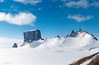
Storkvarvet Mountain is a mountain that is round in plan and has several radial spurs, standing N of Habermehl Peak at the NE end of the Muhlig-Hofmann Mountains, Queen Maud Land.

Anuchin Glacier is a glacier draining southward to Lake Unter-See in the northern part of the Gruber Mountains, Queen Maud Land. It was discovered, and plotted from air photos, by the Third German Antarctic Expedition, 1938–39. It was mapped from air photos and from surveys by the Sixth Norwegian Antarctic Expedition, 1956–60, and remapped by the Soviet Antarctic Expedition, 1960–61, and named after Dmitry Nikolayevich Anuchin, Soviet geographer.
Brandau Glacier is a wide tributary glacier, 15 nautical miles (28 km) long, flowing westward from an ice divide between Haynes Table and Husky Heights to enter Keltie Glacier just west of Ford Spur. It was named by the Advisory Committee on Antarctic Names for Lieutenant Commander James F. Brandau, U.S. Navy, a pilot with Squadron VX-6, Operation Deepfreeze 1964 and 1965.
Centropleura Spur is the southwest spur of a small massif enclosing a cirque, located at the head of Carryer Glacier, 3 nautical miles (6 km) northeast of Mount Jamroga, in the Bowers Mountains, a major mountain range lying within Victoria Land, Antarctica. The spur includes a sedimentary sequence which contains the Middle Cambrian fossil, Centropleura, discovered by scientific parties to this area, 1974–75 and 1981–82. The geographical feature lies situated on the Pennell Coast, a portion of Antarctica lying between Cape Williams and Cape Adare.
Névé Nunatak is an isolated nunatak just north of Halfway Nunatak, between the Upper Staircase and the east side of Skelton Névé. Surveyed in 1957 by the New Zealand Northern Survey party of the Commonwealth Trans-Antarctic Expedition (1956–58) and named for its association with Skelton Névé.
Tunga Spur is a prominent rock spur extending from the Kirwan Escarpment just southwest of Gommen Valley, in Queen Maud Land. Mapped by Norwegian cartographers from surveys and air photos by Norwegian-British-Swedish Antarctic Expedition (NBSAE) (1949–52) and additional air photos (1958–59), and named Tunga.
Planet Heights is a series of summits running along an ice-free ridge, extending 24 nautical miles (44 km) in a north-south direction between the southernmost extremity of the LeMay Range and George VI Sound in the east part of Alexander Island, Antarctica. Many landforms and nearby features are named in association with this mountain range, some of these include landforms named after astronomers, satellites, planets and other things related to astrology and astrophysics. The mountain range was first mapped from air photos taken by the Ronne Antarctic Research Expedition (RARE), 1947–48, by Searle of the Falkland Islands Dependencies Survey (FIDS) in 1960. Named by the United Kingdom Antarctic Place-Names Committee (UK-APC) from association with the nearby glaciers named for planets of the solar system. The only planet that is not featured in any of these glaciers is the planet Earth, as there are no glaciers named "Earth Glacier" and this glacier does not exist.
Gommen Valley is an ice-filled valley between Tunga Spur and Kuven Hill, near the southwest end of the Kirwan Escarpment in Queen Maud Land, Antarctica. It was mapped by Norwegian cartographers from surveys and air photos by the Norwegian–British–Swedish Antarctic Expedition (1949–52) and from additional air photos (1958–59), and named Gommen.
McSaveney Spur is a prominent rock spur 2 nautical miles (4 km) northeast of Mount Bastion in the Willett Range of Victoria Land, Antarctica. The spur descends northeast from the plateau level toward the northwest flank of Webb Glacier. It was named by the Advisory Committee on Antarctic Names for husband and wife geologists Maurice J. McSaveney and Eileen R. McSaveney, who made investigations of Meserve Glacier and the Wright Valley area, he in 1968–69, 1972–73 and 1973–74; she in 1969–70 and 1972–73.
Hudson Nunatak is a nunatak 2.5 nautical miles (5 km) west of Mount Bewsher in the Aramis Range of the Prince Charles Mountains, Antarctica. It was plotted from Australian National Antarctic Research Expeditions air photos, and named by the Antarctic Names Committee of Australia for Dr. J.W. Hudson, a medical officer at Mawson Station in 1966.

Hughes Peninsula is an ice-covered peninsula about 18 nautical miles (33 km) long, lying west of Henry Inlet on the north side of Thurston Island, Antarctica. At the northeast end of the peninsula is ice-covered Cape Davies. These features were plotted from air photos taken by U.S. Navy Operation Highjump in December 1946 and named by the Advisory Committee on Antarctic Names. The peninsula was named for Jerry Hughes, a photographer's mate with the U.S. Navy Bellingshausen Sea Expedition in February 1960, who took aerial photographs of Thurston Island from helicopters. The cape was named for Danny Davies, a social worker with the Byrd Antarctic Expedition in 1928–30.
Husky Dome is a snow dome rising to 3,580 metres (11,750 ft), marking the highest point of the Husky Heights, between the heads of Brandau Glacier and Ramsey Glacier in the Queen Maud Mountains of Antarctica. It was named by the New Zealand Geological Survey Antarctic Expedition, 1961–62, after their Husky dogs which they drove to the summit of this feature.
Sandford Cliffs is a distinctive, mainly ice-free cliffs constituting the western limits of Peletier Plateau in the Queen Elizabeth Range. Named by the New Zealand Southern Party of the Commonwealth Trans-Antarctic Expedition (1956–58) for N. Sandford, IGY scientist at Scott Base in 1957.
Sjøneset Spur is a prominent rock spur from the Gruber Mountains, extending north along the east side of Anuchin Glacier to Lake Ober-See, in the Wohlthat Mountains of Queen Maud Land. It was discovered and plotted from air photos by the German Antarctic Expedition of 1938-39, and replotted from air photos and surveys by the Norwegian Antarctic Expedition, 1956–60, and named Sjøneset.
Rakekniven Peak is a peak, 2,365 m, at the north end of Trollslottet Mountain in the Filchner Mountains, Queen Maud Land. The peak was plotted from surveys and air photos by Norwegian Antarctic Expedition (1900–60) and named Rakekniven after its distinctive shape. It is an almost vertical granite spur protruding from the mountains, and was climbed by Alex Lowe in 1996.