Related Research Articles

Iceland is an island country at the confluence of the North Atlantic and Arctic oceans, east of Greenland and immediately south of the Arctic Circle, atop the constructive boundary of the northern Mid-Atlantic Ridge. The island country is the world's 18th largest in area and one most sparsely populated. It is the westernmost European country when not including Greenland and has more land covered by glaciers than continental Europe. Its total size is 103,125 km2 (39,817 sq mi) and possesses an exclusive economic zone of 751,345 km2 (290,096 sq mi).

Kimball Township is a civil township of St. Clair County in the U.S. state of Michigan. As of the 2020 census, the township population was 9,609.

Weyers Cave is a census-designated place (CDP) in Augusta County, Virginia, United States. The population was 2,700 at the 2020 census. It is part of the Staunton–Waynesboro Micropolitan Statistical Area.

A lava tube, or pyroduct, is a natural conduit formed by flowing lava from a volcanic vent that moves beneath the hardened surface of a lava flow. If lava in the tube empties, it will leave a cave.
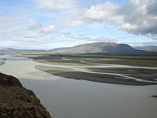
Þjórsá is Iceland's longest river at 230 kilometres (140 mi). It is in the south of the island.

Eyrarbakki is a fishing village on the south coast of Iceland with a population of about 570 people, not including inhabitants of the prison located there. The village is founded on the Great Þjórsá Lava.
Buri may refer to:
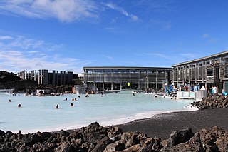
The Blue Lagoon is a geothermal spa in southwestern Iceland. The spa is located in a lava field 5 km (3.1 mi) from Grindavík and in front of Mount Þorbjörn on the Reykjanes Peninsula, in a location favourable for geothermal power, and is supplied by water used in the nearby Svartsengi geothermal power station. The Blue Lagoon is approximately 20 km (12 mi) from Keflavík International Airport, and is one of the most visited tourist attractions in Iceland.
Stokkseyri is a small town in Southern Iceland, with a population of around 445.

The Ministry for Foreign Affairs is an Icelandic cabinet-level ministry founded 18 November 1941. The ministry is responsible for foreign policy, diplomatic missions, trade, foreign aid, and interactions with international organizations among other tasks.

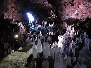
Víðgelmir is a lava tube situated in the Hallmundarhraun lava field in west Iceland, around 2 km southeast of Fljótstunga farm in Hvítársíða, Borgarfjörður. The roof of the lava tube has collapsed, creating two large openings near its north end which are the only known entrances. Víðgelmir is 1585 m long and the largest part of the cave passage is 15.8 m high and 16.5 m wide, making it by far the largest of its kind in Iceland. The cave has a wide entrance but narrows down in some places. An iron gate was installed at the first constriction in 1991 to preserve those of the delicate lava formations or speleothems which hadn't already been destroyed. Evidence of human habitation, probably dating to the Viking Age, has been discovered in the cave and is preserved in the National Museum of Iceland. Long stretches of the cave floor are very rough and shouldn't be navigated without a guide. Access and guided tours are provided at nearby Fljótstunga.

Ölfus is a municipality located in Iceland. The major town is called Þorlákshöfn. The bottled water brand Icelandic Glacial is manufactured in this area, at the Ölfus spring.

Surtshellir is a lava cave located in western Iceland, around 60 km from the settlement of Borgarnes. Approximately a mile in length, it is one of the longest such caves in the country. It was the first known lava tube in the world, at least by modern speleologists, and remained the longest known lava tube until the end of the 19th century. While mentioned in the medieval historical-geographical work Landnámabók, Eggert Ólafsson was the first to give a thorough documentation of the cave in his 1750 travels of the region. It is named after the fire giant Surtr, a prominent figure in Norse mythology, who is prophesied to one day engulf the world in the fire of his flaming sword.
Yorkville is an unincorporated community in Mendocino County, California. It is located 7.5 miles (12 km) southwest of Hopland, at an elevation of 922 feet (281 m).

Silfra is a rift formed in the Mid-Atlantic Ridge – the divergent tectonic boundary between the North American and Eurasian plates – and is located in the Þingvallavatn Lake in the Þingvellir National Park in Iceland.

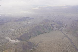
The Great Þjórsá Lava is the largest lava flow in Iceland and the largest lava flow that is known to have erupted in a single eruption in the Holocene. Þjórsá Lava has a total volume of more than 25 km3 (6.0 cu mi), covering approximately 900 km2 (350 sq mi). The Þjórsá Lava does not appear on the surface until 70 km (43 mi) downstream of its identified eruptive area.

Mammoth Cave is a lava tube located on the Markagunt Plateau in the Dixie National Forest of Southern Utah, and is one of the largest lava tubes in Utah. The cave has over 2,200 feet of passage and is about a quarter mile long. It was formed by cooling lava and water less than 2,000 years ago. Due to moisture and its elevation of 8,050 feet above sea level the cave stays cool year round.
Raufarhólshellir is the fourth-longest lava tube in Iceland. The cave's proximity to Reykjavík made it popular with visitors, who caused damage to the cave. In late 2016 the cave was closed to the public to clear accumulated garbage and install lighting and a walkway to part of the cave. The cave reopened for guided tours the following year.
Leitin is a small shield volcano in the southwest of Iceland.
References
- ↑ "Búri Cave Closed". visir.is. Retrieved 2015-07-26.
63°54′50″N21°29′4″W / 63.91389°N 21.48444°W
| | This Iceland location article is a stub. You can help Wikipedia by expanding it. |