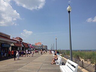
Rehoboth Beach is a city on the Atlantic Ocean along the Delaware Beaches in eastern Sussex County, Delaware, United States. As of the 2010 United States Census, the population was 1,327, reflecting a decline of 161 (11.2%) from the 1,488 counted in the 2000 Census. Along with the neighboring coastal city of Lewes, Rehoboth Beach is one of the principal cities of Delaware's rapidly growing Cape Region. Rehoboth Beach lies within the Salisbury metropolitan area.

Hardap is one of the fourteen regions of Namibia, its capital is Mariental. Hardap contains the municipality of Mariental, the towns Rehoboth and Aranos, and the self-governed villages Gibeon, Gochas, Kalkrand, Stampriet and Maltahöhe. It is home to the Hardap Dam.

The Basters are a Southern African ethnic group descended from white European men and black African women, usually of Khoisan origin, but occasionally also enslaved women from the Cape, who resided in the Dutch Cape Colony in the 18th century. Since the second half of the 19th century, the Rehoboth Baster community has been concentrated in central Namibia, in and around the town of Rehoboth. Basters are closely related to Afrikaners, Cape Coloured and Griqua peoples of South Africa, with whom they share a language and culture.

Rehoboth is a town in central Namibia just north of the Tropic of Capricorn. Located 90 kilometres south of the Namibian capital Windhoek, Rehoboth lies on a high elevation plateau with several natural hot-water springs. It receives sparse mean annual rainfall of 240 millimetres (9.4 in), although in the 2010/2011 rainy season a record 731 millimetres (28.8 in) were measured. In 2005, it had a population of 21,378 later increased to 28,843 in 2011, according to the 2011 Namibian Population and Housing Census.
Delaware Route 1 (DE 1) is a 102.63-mile-long (165.17 km) state highway in the U.S. state of Delaware. The route runs from the Maryland state line in Fenwick Island, Sussex County, where the road continues south into that state as Maryland Route 528 (MD 528), north to an interchange with Interstate 95 (I-95) in Christiana, New Castle County, where the road continues north as part of DE 7. Between Fenwick Island and Dover Air Force Base in Dover, Kent County, DE 1 is a four- to six-lane divided highway with at-grade intersections and occasional interchanges. The route heads north through the Delaware Beaches resort area along the Atlantic Ocean before it runs northwest through rural areas, turning north at Milford to continue to Dover. Upon reaching Dover, DE 1 becomes the Korean War Veterans Memorial Highway, a four- to six-lane freeway that is partially tolled. Between Dover and Tybouts Corner, DE 1 parallels U.S. Route 13 (US 13), crossing over and featuring interchanges with it multiple times. Past Tybouts Corner, the freeway heads north parallel to DE 7 to its terminus in Christiana. DE 1 serves as the main north-south state route in Delaware, connecting the Delaware Beaches with the Dover and Wilmington areas.

Rehoboth Rural is a constituency in the Hardap region of Namibia. It had a population of 7,288 in 2011, down from 7,524 in 2001. Among the settlements in Rehoboth Rural are Klein Aub, Khauxas, and Schlip. As of 2020, the constituency had 4,701 registered voters.

Rehoboth Urban East is an electoral constituency in the Hardap region of Namibia, comprising the suburbs of Rehoboth that are situated to the east of the national road B1. It had a population of 18,035 in 2011, up from 12,891 in 2001. As of 2020 the constituency had 12,112 registered voters.

Delaware Route 1A (DE 1A) is a state highway in Sussex County, Delaware. The route runs 2.01 mi (3.23 km) from DE 1 in the town of Dewey Beach to another intersection with DE 1 west of the city of Rehoboth Beach. The route provides access to Rehoboth Beach from DE 1, heading north before turning to the west. DE 1A follows King Charles Avenue, Bayard Avenue, 2nd Street (southbound), Christian Street (northbound), and Rehoboth Avenue.

Delaware Route 14 (DE 14) is a state highway in the southern part of Kent County, Delaware. The route runs from the Maryland state line near Burrsville, Maryland, where the road continues as Maryland Route 317 (MD 317), east to DE 1 in Milford. The route passes through Harrington, where it intersects U.S. Route 13 (US 13), and passes to the north of Houston before coming to Milford, where it intersects DE 15, US 113, and DE 1 Business. DE 14 has a truck bypass of Harrington known as DE 14 Truck.
The National Archives of Namibia (NAN) is the national archives of Namibia, located in Windhoek. It was established in 1939 and today shares a building with the National Library of Namibia.

Rietoog is a settlement in the Hardap Region of Namibia. It is situated 112 kilometres (70 mi) southwest of Rehoboth and 130 kilometres (81 mi) north of Maltahöhe along the M47 gravel road. The name Rietoog means Cane-eye, named after a spring that looks like an eye, surrounded by canes, near the town.
C25 is a secondary route in Namibia that runs from the northern B1 junction in Rehoboth to the C23 near Leonardville.
Petrus "Piet" Matheus Junius was a Namibian politician who served as the Deputy Education Minister of the Interim Namibian Government from 1985 to 1989.
John McNab was a Namibian politician who served as Rehoboth Baster captain from 1999 until 2020.
The Rehoboth area, historically the Free Republic of Rehoboth is an unrecognized state in central Namibia, inhabited by the indigenous Baster people.
The Baster Council, is the parliament of the unrecognized state of the Rehoboth area in Namibia. It forms the legislature, or Volksraad, of Rehoboth together with the executive Captains Council (Kapteinsraad).
The Captainsof the Rehoboth Baster were the indigenous Baster community in central Namibia, until the dissolution of the Rehoboth Homeland in 1990, upon Namibian independence.
Cornelius van Wyk was the second Captain of the Rehoboth Baster, serving from 1914 until his death in 1924.
C29 is a secondary route in Namibia that runs from the south, at the B6 junction approximately 65 miles east of Windhoek. The C29 then terminates to the north at the C22 junction near Otjinene.
C31 is a secondary route in Namibia that runs from the Okahandja at the B1 junction up north-westerly to Summerdown, Omaheke, where it meets the C29.
