
Jhelum is a city on the east bank of the Jhelum River, which is located in the district of Jhelum in the north of Punjab province, Pakistan. It is the 44th largest city of Pakistan by population. Jhelum is known for providing many soldiers to the British Army before independence, and later to the Pakistan armed forces – due to which it is also known as City of Soldiers or Land of Martyrs and Warriors.

Majha is a region located in the central parts of the historical Punjab region split between India and Pakistan. It extends north from the right banks of the river Beas, and reaches as far north as the river Jhelum. People of the Majha region are given the demonym "Mājhī" or "Majhail". Most inhabitants of the region speak the Majhi dialect, which is the basis of the standard register of the Punjabi language. The most populous city in the area is Lahore on the Pakistani side, and Amritsar on the Indian side of the border.
Muftian is a village situated in Tehsil Dina Jhelum District, Punjab, Pakistan.

Bura Jungle is a village located three miles east of Dina City in Jhelum District, Punjab, Pakistan, six miles from the famous Rohtas Fort. The population is around 1500 people, the majority of whom belong to the Gujjar tribe. The Grand Trunk Road passes through the village connecting Lahore and Rawalpindi. Bura Jungle Mosque is a famous landmark in the area of Jhelum and is situated in the village.
Kala Gujran is a town and union council of Jhelum District in the Punjab Province of Pakistan. It is part of Jhelum Tehsil, and is located at 33°10'48N 72°57'59E with an altitude of 467 metres (1535 feet).
Kharian Cantonment, (Punjabi: کھاریاں ﮐﻴﻨٹ) or Kharian Cantt is one of the largest Cantonment in Pakistan. It is located near Kharian city, in the Gujrat district of Punjab province.
Motian is a village in Jhelum District, Punjab province, Pakistan.

Jhelum Cantt. or Jhelum Cantonment is cantonment area in Jhelum adjacent to the city area.
Daulatpur is a village and union council of Jhelum District in the Punjab Province of Pakistan. It is part of Pind Dadan Khan Tehsil. It is located approximately four kilometers away from the Pind Dadan Khan-Jhelum Road on the north side of Pinanwal. The population of this village is approximately 4000.
Nougran Shareef is a village in Jhelum District, Punjab, Pakistan. Nougran Shareef is a village almost 6.9 miles west of the main city Jhelum pass by CMH, consisting of 610 houses and a population of 6,810 approx.
Behak Mekan is a small town located in the Sargodha District ضلع سرگودھا of the Punjab province, Pakistan, that was formed when the area was part of the British Empire. The town is placed 16.5 kilometres (10.3 mi) away from the city of Sargodha and 10 kilometres (6.2 mi) away from Dhreema. Due to the town's ecological site, the British Royal Air Force (RAF) built an airstrip near "godhay wala" that become of great significance to the Pakistan Air Force after the Pakistan Movement independence of Pakistan.
Bugga is a village in Pind Dadan Khan Tehsil of Jhelum District in Punjab, Pakistan.
Nara Mughlan is a tiny village situated on the Potohar Plateau in Northern Punjab, approximately 80 km from Islamabad, Pakistan. It can be accessed from Motorway as well as from Grand Trunk (GT) Road, Islamabad – Lahore. Its distance from Chakwal city is about 39–40 km and it lies beside the Rajian oil fields. A by-road originating from the main road, 3–4 km ahead of village Mulhal Mughlan, leads directly to the village Nara Mughlan. The road passes through the Rajian oil fields which are located on the outskirts of the village. Nara Mughlan is bounded by villages Joorh in the North, Jand in the West, Chauntariyan in the South and Jhelum – Chakwal Road in the East.
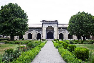
Pathar Mosque, known locally as Naev Masheed, is a Mughal era stone mosque located in the old city of Srinagar, in the Indian state of Jammu and Kashmir. It is located on the left bank of the River Jhelum, just opposite the shrine of Khanqah-e-Moula. It was built by Mughal Empress Noor Jehan, the wife of emperor Jehangir, in 1623, for Shi’a Muslim Population. Soon after its construction, the mosque was declared unfit for prayers and was used instead for non-religious purposes. The structure was reconverted into a mosque in the early 1930s. The mosque has some distinct features that separate it from the rest of the mosques in the Kashmir Valley. Unlike other mosques, it does not have the traditional pyramidal roof. Furthermore, the mosque has nine mehraabs (arches), with the central one being larger than the others.

Multan Cantt or Multan Cantonment is a cantonment in the Multan District, adjacent to Multan city, in Punjab province, eastern Pakistan. Multan Cantt is located in the city's southwest.
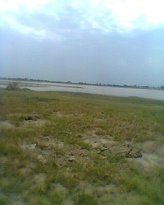
Kala Deo is a village located in the Northern Punjab in Pakistan close to the Jhelum River. Geographical location: Jhelum, Punjab, Pakistan, Asia geographical coördinates: 32° 59' 0" North, 73° 46' 0" East about 60 mi South-East of Islamabad, the country's capital.

Lilla (للہ) is a small city and union council of Jhelum District in the Punjab Province of Pakistan. It is part of Pind Dadan Khan Tehsil.
Mirza Abad, also known as Mirzaabad, is a village in Union Council Daulatpur Pind Dadan Khan Tehsil, Jhelum District,Pakistan. It is Located at 32°41'12.71N' 73°20'48.99E with an altitude of 190 metres, near the Salt Range and Khewra Salt Mine.


